September, 1936 Flood Event
Click images to expand.
 According to the San Angelo Standard Times reports, the flood destroyed 300 houses, damaged 700 more and caused $2 million worth of uninsured damage. Rescuers pulled more than 100 people from the flooded streets and houses. Reports noted that instantly, the number of homeless people reached 300. Two bridges were destroyed along the Concho River. Only the Chadbourne Bridge survived the raging flood waters. Amazingly this bridge survived, even with 38 houses smashing into it from the swiftly flowing water. Floodwaters claimed 12 buildings on Concho Avenue between Chadbourne and Koenigheim. The whole block of Avenue B between Abe and Koenigheim was washed away. The most dramatic rescue was at the Naylor Hotel at the corner of Concho and Chadbourne, when 75 people evacuated the hotel due to water in the lobby being six feet deep.
Meteorological Analysis
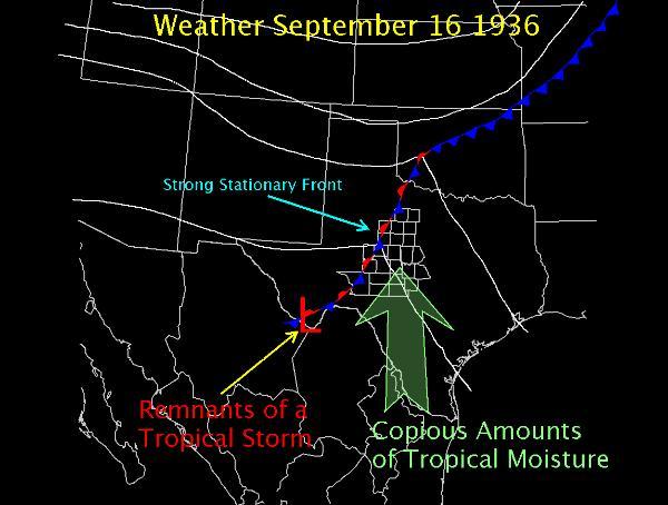
The meteorological parameters were very favorable for a major flood of this magnitude (Fig 1). The remnants of a tropical storm which moved into deep South Texas from the Gulf of America on September 14th, was located over the Big Bend by September 16th. A strong stationary front extended from the Big Bend northeast across West Central and Northwest Texas. In addition, an abundant amount of tropical moisture was flowing northwest across West Central Texas during the four day period. These ingredients led to rounds of thunderstorms with very heavy rainfall.
Rainfall Analysis
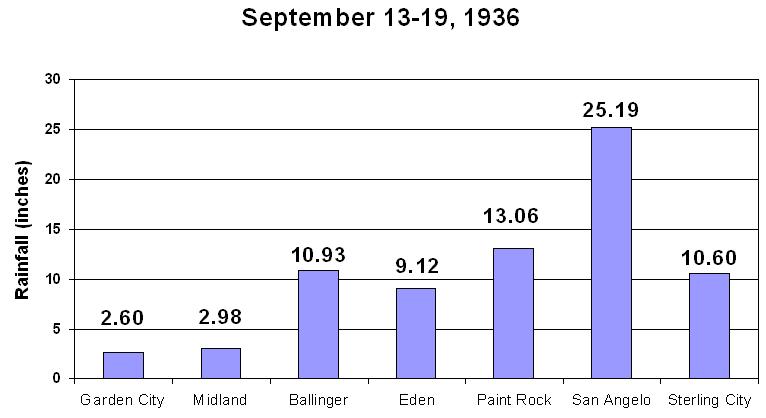 There was a large area of rainfall greater than 12 inches across Tom Green, Concho, Schleicher, Sutton and Kimble Counties. Rainfall amounts of greater than 20 inches covered central and southern Tom Green County and central Schleicher County. Rainfall amounts for Ballinger, Eden, Paint Rock, San Angelo and Sterling City are shown in Figure 2.
The month of August, 1936, was a dry month for the Concho Valley with most precipitation stations recording less than 0.50 of an inch of rain. San Angelo recorded 0.08 of an inch of rain for the month of August. The dry antecedent conditions of the West Texas landscape played a little role in absorbing the volume of water produced by the heavy rainfall brought by the mid September event. On September 15, San Angelo received 11.75 inches of rain. The 100-year, 24 hour rainfall amount for the San Angelo area is approximately 8.3 inches. 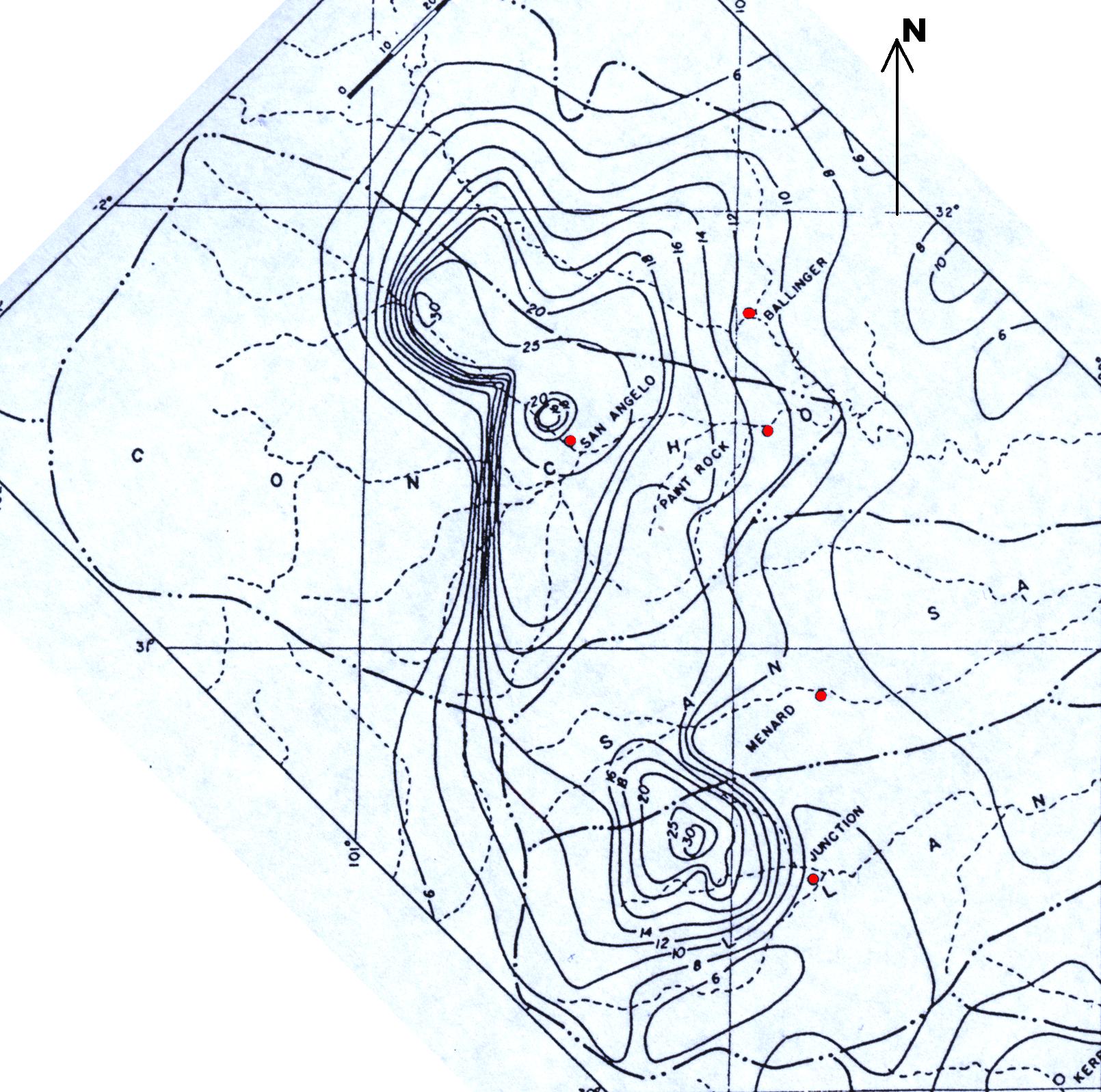 Additional 24 hour totals for San Angelo included 1.16 inches on the 16th, 4.65 inches on the 17th and 7.64 inches on the 18th. Figure 3 is an isohyetal map of the Concho River basin constructed by the USGS showing total rainfall, in inches, observed September 13-18, 1936.
Hydrological Analysis
The result of these extraordinary rainfall events was catastrophic flooding. As shown in Figure 4, the average daily streamflows from USGS records indicate that the North and South Concho Rivers rose sharply. A large volume of water was also delivered down the Middle Concho River, but there are no historical records for the river. According to USGS Water-Supply Paper 816, the flood stages reached on the North Concho River were higher than known before. 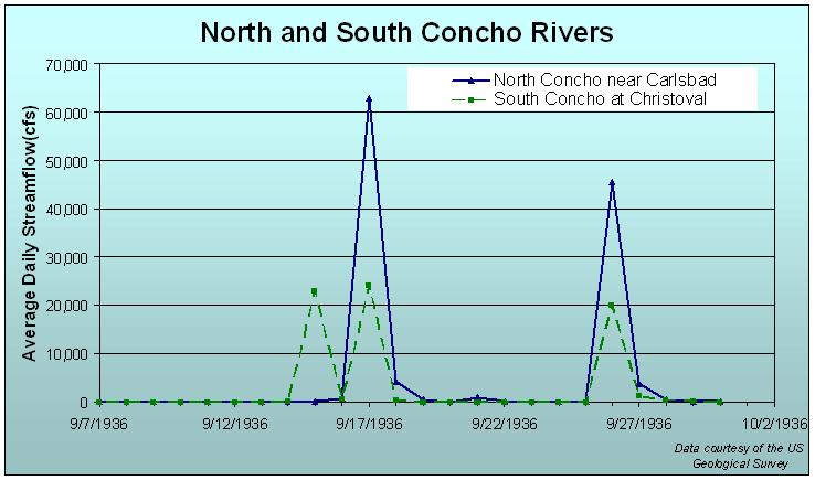
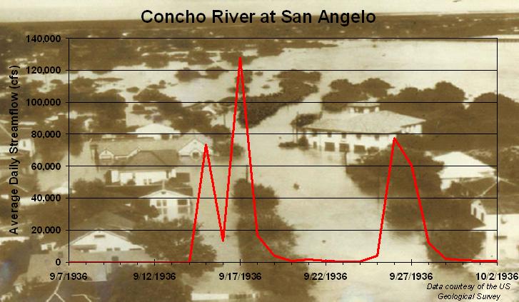
As shown in Figure 5, three separate flood peaks occurred on the Concho River at San Angelo. USGS Water-Supply Paper 816 indicated that the city of San Angelo suffered greater damage than any other place in the State. The Report states that on September 17, the discharge of the South Concho River reached a maximum of 111,000 cubic feet per second (cfs) and caused stages which backed water up the North Concho River to the center of the city. Just as this water began to recede, the flood from the North Concho River with a peak discharge of 184,000 cfs, reached the city. The river channel was inadequate for this enormous quantity of water and the river broke over its banks, flooding large areas of the residential and business sections of the city.
 At the time of the September, 1936, flood event, the only major man-made dam in the San Angelo area was the Nasworthy Dam. The small dam was not designed to control an event of this magnitude. The design and construction of O.C. Fisher Dam, by the U.S. Army Corps of Engineers on the North Concho River was intended to control flood waters. According to the engineering plans, O.C. Fisher Dam has 277,200 acre-feet of capacity assigned to flood control. This flood storage, combined with spillways and outlet works capacities, will control the inflow design flood with a peak of 614,500 cfs and a spillway design flood volume of 1,054,600 acre-feet.
Twin Buttes Dam provides flood control of the Middle and South Concho Rivers above Lake Nasworthy. According to the U.S. Bureau of Reclamation, Twin Buttes Reservoir has 454,370 acre-feet of capacity assigned to flood control. This flood storage, combined with spillway and outlet works capacities, is sufficient to protect against the inflow design flood with a peak of 725,000 cfs and a three-day volume of 825,000 acre-feet.
Event summarized by:
Mark Cunningham & Jason Johnson

