With a somewhat unsettled pattern, a variety of weather occurred across west-central Texas on March 17-19. After very dry air occupied the region on Mar. 16, moisture made a quick return on the morning of Mar. 17. Scattered afternoon and early evening thunderstorms occurred across parts of the eastern half of west-central Texas. The storms occurred mainly in the unstable air ahead of an advancing dryline from the west, and along and south of a cold front. Although no reports were received, some of the storms were strong and likely contained small hail and gusty winds. Figure 1 shows an animated loop of radar imagery, with the scattered thunderstorms on the afternoon of Mar. 17.
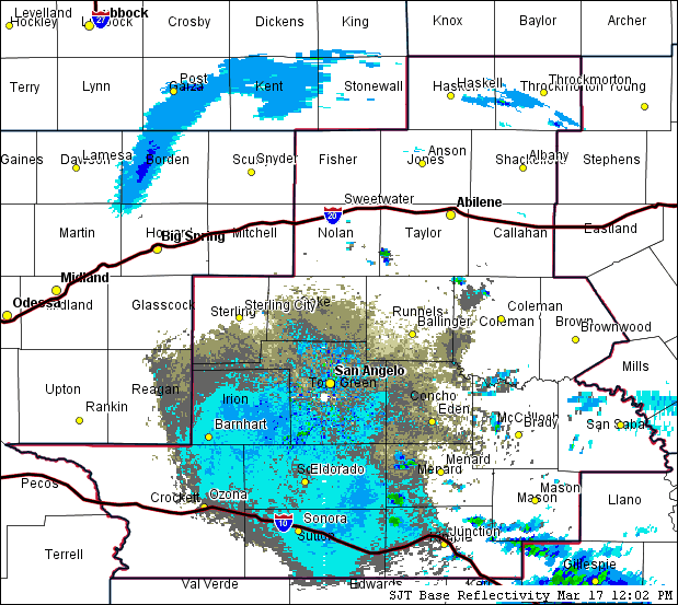
Figure 1: Animated Loop of Radar Imagery on March 17 (between Noon and 4 PM).
To the west of the dryline, warm and breezy conditions were combined with very dry air. Relative humidity values dropped into the 10-15 percent range, with temperatures in the 80s and gusty southwest to west winds.
During the evening and early nighttime hours, the dryline retreated west while the cold front advanced south, before stalling north of the Interstate 10 corridor. Cool and moist conditions behind this front resulted in low cloud and fog development. Fog was locally dense in the Coleman and Brady areas.
On the morning of Mar. 18, the front lifted north across west-central Texas as a warm front. A few showers occurred across the Big Country area. A dryline advanced east across the area during the late morning and afternoon hours. Behind this dryline, temperatures in the 80s were combined with gusty west winds and very dry air. Afternoon relative humidity values dropped into the 8-15 percent range across much of the area.
The arrival of a cold front, during the overnight hours of Mar. 18-19, brought strong winds to northern parts of west-central Texas. Peak wind gusts across that area were mostly 40-50 mph, although a 57 mph gust was recorded by a Mesonet station near Stamford. In the wake of the cold frontal passage, gusty northwest winds continued during the day on Mar. 19.


 Virtual Tour
 Current Observations
 Weather Briefing
 Satellite Loops
 Past Weather Reports
 Past Rainfall Maps
 Drought Information
 River & Lake Levels
 Fire Weather
 Aviation Weather
 Additional Resources
 Social Media