
Severe thunderstorms are expected across the Central Plains accompanied by damaging wind gusts and large hail. In addition, heavy rainfall may lead to instances of flash flooding from the Plains and mid-Atlantic regions. The heavy rainfall threat continues across Florida and across the northern Gulf as we monitor a tropical disturbance tracking westward. Critical fire weather for the Great Basin. Read More >
Temperatures averaged well-above normal for the month. Table 1 summarizes October 2016 temperature, precipitation, and departure from normal for Abilene and San Angelo.
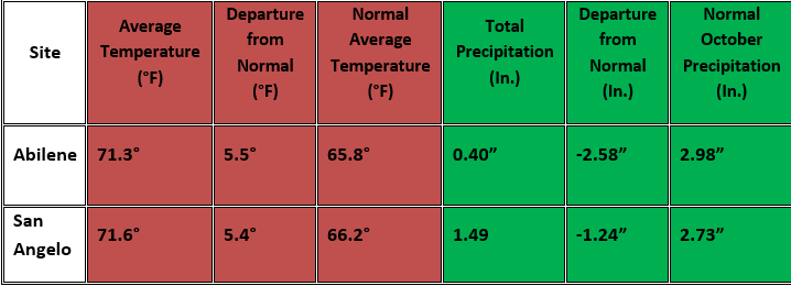
Table 1: October Climate Data for Abilene and San Angelo.
Additional temperature and precipitation data for Abilene and San Angelo is summarized in Table 2.
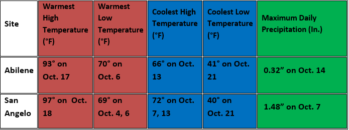
Table 2: Additional October Climate Data for Abilene and San Angelo.
Maps of total precipitation for August (Figure 1) and percent of normal precipitation for the month (Figure 2) are shown below.

Figure 1: Total Precipitation for October.
October precipitation varied from less than one tenth of an inch in southern parts of west-central Texas, to over 5 inches in parts of the eastern Big Country. Most of the locations receiving over 2 inches were across the northern half of west-central Texas. The higher monthly precipitation amounts (3-5 inches with isolated amounts over 5 inches) occurred in eastern parts of the Big Country.
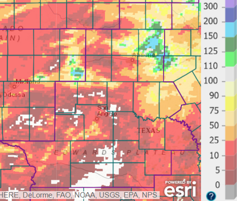
Figure 2: Percentage of Normal Precipitation for October.
With the exception of the eastern Big Country, the monthly precipitation was well-below normal across west-central Texas (red and white shading).
Weather Highlights:
October began with a warming trend in temperatures, followed by very warm afternoon temperatures with increased humidity on Oct. 4-6. Isolated showers and thunderstorms occurred during that time.
A strong cold front moved south across west-central Texas between Midnight and 10 AM on the 7th, and showers and thunderstorms occurred following the frontal passage. Rainfall was locally heavy. The highest amounts (2-3 inches) occurred in parts of Shackelford County, while 1-2 inches occurred at widely scattered locations elsewhere.
With much cooler air behind the front and considerable cloud cover, daytime temperatures only reached the 60s across the area.
Generally pleasant weather conditions occurred on the 8th and 9th with weaker winds, and some lingering cloud cover over west-central Texas.
Scattered thunderstorms with frequent lightning and locally heavy rain occurred across the northern half of west-central Texas, between Midnight and 10 AM on the 14th with the arrival of an upper level disturbance. Figure 3 captures this rainfall, for the 7-day period ending October 15.
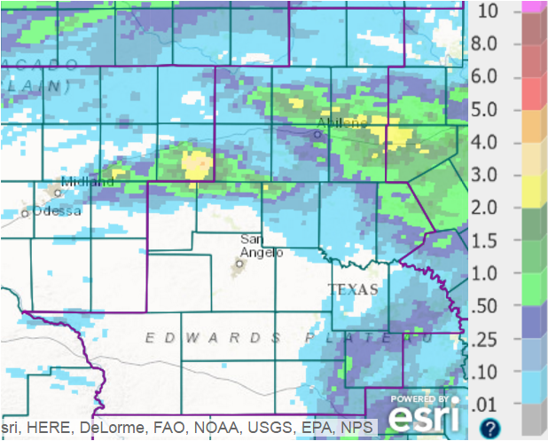
Figure 3: West-Central Texas Rainfall for the 7-Day Period Ending at 7 AM, October 15.
Scattered locations north of a Sterling City to Brownwood line received 1-2 inches of rainfall. A few areas (yellow shading) received 2-3 inches.
Temperatures were 10-15 degrees above normal on October 15-17, when an upper level high pressure system shifted very slowly east across Texas. This was accompanied by breezy south winds and fairly humid conditions for the time of year. On the 16th and 17th, highs were in the 90-95 degree range across west-central Texas. Temperatures were cooler across the Big Country on the 18th following passage of a cold front, but the heat continued farther south where highs were in the lower to mid 90s. A record high of 97 degrees was set at San Angelo on the 17th.
Much cooler air and gusty north-northeast winds on the 20th followed the overnight passage of a strong cold front. Scattered thunderstorms with locally heavy rain accompanied the frontal passage across the Big Country north and east of Abilene. Only isolated showers and thunderstorms occurred farther to the south. Figure 4 shows rainfall for the 24-hour period ending at 7 AM, October 20.
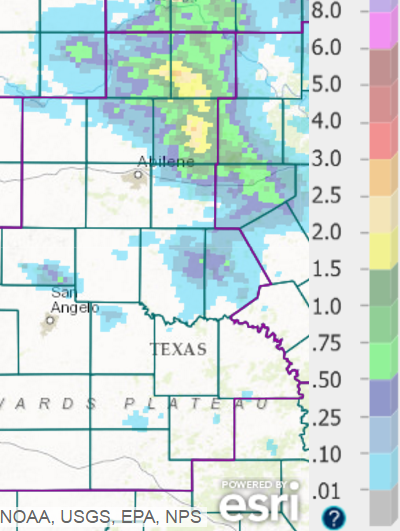
Figure 4: Rainfall for the 24-Hour Period Ending at 7 AM, October 20.
Some locations northeast of Abilene received between 1.5 and 2.5 inches of rainfall (yellow shading).
After a very warm day on the 19th, highs on the 20th were in the 70s. As a high pressure system settled south into Texas, a combinatio of clear skies, drier air and light winds allowed temperatures to drop into the 40s for early morning lows on the 21st. Pleasant daytime temperatures continued on the 22nd, followed by a warming trend on October 22-23 with the resumption of south winds.
Warm and dry conditions occurred during the final week of October, with well-above normal temperatures.


 Virtual Tour
 Weather Briefing
 Satellite Loops
 Past Weather Reports
 Past Rainfall Maps
 Drought Information
 River & Lake Levels
 Fire Weather
 Aviation Weather
 Additional Resources
 Social Media