Weather and Climate Summary for March 2016
Figure 1 shows the geographic regions across West Central Texas, which are referenced in this summary.

Figure 1: Geographic Regions of West-Central Texas.
Temperatures averaged above normal for the month. Table 1 summarizes March 2016 temperature, precipitation, and departure from normal for Abilene and San Angelo.
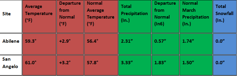
Table 1: March Climate Data for Abilene and San Angelo.
Additional temperature and precipitation data for Abilene and San Angelo is summarized in Table 2.

Table 2: Additional March Climate Data for Abilene and San Angelo.
The monthly precipitation for March (Figure 2) and percent of normal precipitation for the month (Figure 3) are shown below.
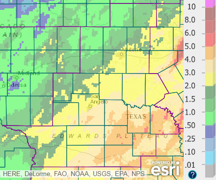
Figure 2: Total Precipitation for March.
Total precipitation for March ranged from less than 1 inch across the northwestern Big Country, to more than 5 inches at a few locations across the southeastern part of west-central Texas.
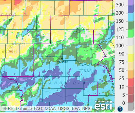
Figure 3: Percentage of Normal Precipitation for March.
The monthly precipitation was below normal across much of the Big Country north and west of Abilene. March precipitation was above normal across most the central and southern parts of west-central Texas.
Temperatures were above normal during the first several days of the month with a couple of weak, dry cold frontal passages. Low-level moisture returned to the area on the 5th and 6th with southeast and south winds.
A significant severe weather event occurred on March 8, with significant rainfall March 8-11.
A strong upper level storm system moved into northwestern Mexico on the 8th, and then tracked slowly across central Mexico on the 9th and 10th. The slow-moving system lifted northeast into south Texas on the 11th, and tracked north-northeast across Texas on the 12th.
Severe Weather
Two episodes of severe weather occurred on the 8th. Moisture returned to west-central Texas, well out ahead of the main upper level storm system. With the arrival of a couple of disturbances into an unstable airmass ahead of the main system, showers and thunderstorms occurred with fairly widespread coverage.
The first episode of severe weather occurred during the post-Midnight and early morning hours of the 8th. Numerous severe storms produced large hail and damaging winds.
The second severe weather episode occurred during the evening and early nighttime hours, with large hail, a tornado, and damaging winds. The tornado (rated EF-1 on the Enhanced Fujita Scale) occurred in extreme northern Mason County, near the border with Mcculloch County. The supercell storm which produced this tornado was unusually powerful for early march, and contained very large hail (tennis ball up to softball size).
In all, a total of 29 severe weather reports were received from the events on March 8.
Significant Rainfall
The showers and thunderstorms on the 8th contained locally heavy rainfall. With the slow approach of the main upper level storm system, additional periods of showers occurred on the 9th through 11th. New record daily rainfall records were set at Abilene (1.49 inches) on the 8th, and at San Angelo (1.78 inches) on the 11th. Figure 4 (below) shows total rainfall for March 8-11 across west-central Texas.
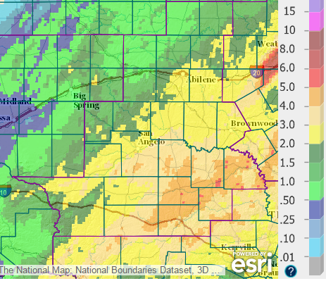
Figure 4: Precipitation for the 7-day period ending at 6 AM, March 12.
The highest rainfall amounts (4-5 inches with isolated higher totals) occurred across the southeastern part of west-central Texas. Rainfall totals of 2 to 4 inches were common across the area southeast of a line from Abilene to Robert Lee to Ozona. The lowest amounts (less than one inch) occurred across the northwestern Big Country. This beneficial rainfall occurred over a period of a few days and flooding was minimized.
Daytime temperatures were cool (in the 50s) on the 11th with cloudy skies, rain and north winds.
Conditions were much warmer and drier on March 13-14. As an upper level disturbance tracked north of our area across southern Oklahoma, gusty west-northwest winds occurred on the 13th. Highs on the 13th were mostly in the upper 70s to lower 80s. With sunny skies and west-southwest winds on the 14th, highs were in the mid to upper 80s. Afternoon relative humidity values dropped into the 10-20 percent range on the 14th. Warm daytime temperatures continued through the 17th with highs mostly in the upper 70s to lower 80s.
A strong cold front advanced south across west-central Texas on the 18th. Temperatures fell into the 50s behind the front across the northern half of the area. Farther south along the Interstate 10 corridor, temperatures reached the 80-85 degree range before arrival of the cold front. Temperatures were much cooler area wide on the 19th, with highs in the upper 50s to lower 60s. With a ridge of high pressure over Texas, a light freeze occurred on the early morning of the 20th.
After a chilly start to the day on the 21st (lows mostly in the 30s), temperatures rebounded with the return of south winds. Temperatures were above normal on the 22nd and 23rd, with gusty south winds on the 22nd. As an upper level disturbance moved across the southern Plains, scattered showers and thunderstorms occurred on the 23rd with the arrival of a dryline and cold front. Quarter size hail was reported from a severe storm in San Saba County (7 miles northeast of San Saba).
Mainly dry conditions prevailed through the remainder of the month. Gusty north winds followed passage of a cold front on Easter Sunday (March 27).


 Virtual Tour
 Current Observations
 Weather Briefing
 Satellite Loops
 Past Weather Reports
 Past Rainfall Maps
 Drought Information
 River & Lake Levels
 Fire Weather
 Aviation Weather
 Additional Resources
 Social Media