Climate Summary for July 2016
Temperatures averaged well-above normal for the month. Table 1 summarizes July 2016 temperature, precipitation, and departure from normal for Abilene and San Angelo.
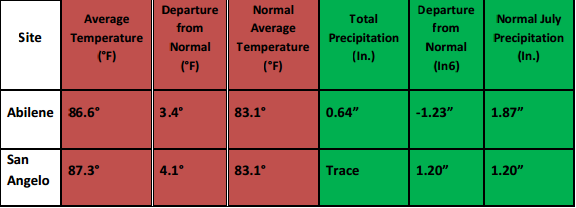
Table 1: June Climate Data for Abilene and San Angelo.
* This was the 6th warmest July on record for San Angelo. *
* The driest July on record was tied at San Angelo. *
Additional temperature and precipitation data for Abilene and San Angelo is summarized in Table 2.
.PNG)
Table 2: Additional July Climate Data for Abilene and San Angelo.
Only a trace of precipitation was recorded during the month at the San Angelo Regional Airport.
Maps of total precipitation for July (Figure 1) and percent of normal precipitation for the month (Figure 2) are shown below.
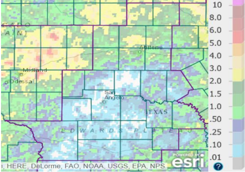
Figure 1: Total Precipitation for July.
Scattered areas across central and southern parts of west-central Texas received less than one hundredth of an inch (zero or trace) of rainfall in July (denoted by whide shading). The highest rainfall amounts (2-3 inches) occurred at a few locations south of Interstate 20, and at at scattered locations to the north.
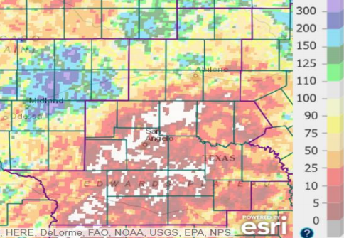
Figure 2: Percentage of Normal Precipitation for July.
The monthly precipitation was well-below normal (less than 25 percent of normal) across most of west-central Texas south of Interstate 20. Above normal precipitation (denoted by the green and blue shading) occurred in northwestern Sterling County, and in parts of the Big Country north of Abilene.
Hot and dry conditions prevailed during most of July for west-central Texas, when upper level high pressure systems were in close enough proximity to dominate the weather pattern. Abilene and San Angelo both officially recorded their first 100-degree temperatures on July 4. The number of days with high temperatures 100 degrees or more were: 21 at San Angelo, 12 at Junction, and 9 at Abilene.
On several occasions, showers and thunderstorms occurred across various parts of west-central Texas. Locally heavy rainfall which accompanied the showers and thunderstorms was spotty.
A cluster of strong to severe thunderstorms affected the Big Country on the evening and nighttime hours of July 4. The severe storms contained large hail (quarter to half-dollar size) and wind gusts 60-65 mph. Wind damage was reported at Noodle and Hawley, in Jones County.
An area of showers and thunderstorms moved southeast into the Big Country and northwestern Concho Valley during the post-Midnight hours of the 9th. Other scattered showers and thunderstorms occurred across parts of the Big Country and Heartland, along with Sutton County, between 6 PM and 11 PM on the 9th. Wind damage was reported with one of the storms in Jones County.
Late in the month, isolated to scattered showers and thunderstorms occurred across various parts of west-central Texas on July 25-30. A 60 mph wind gust occurred with one of the storms 11 miles southwest of Sweetwater (Nolan County).

