
A significant heat wave continues for the Rockies, Northern Plains, and Great Lakes into the Mid-Atlantic, peaking in intensity through midweek and lingering across parts of the Northern Plains and Midwest until this weekend. Excessive rainfall my bring life-threatening and locally catastrophic flash and urban flooding across portions of southwestern Texas through early Friday. Read More >
Weather and Climate Summary for February 2016
Figure 1 shows the geographic regions across West Central Texas, which are referenced in this summary.

Figure 1: Geographic Regions of West-Central Texas.
Temperatures averaged above normal for the month. Table 1 summarizes February 2016 temperature, precipitation, and departure from normal for Abilene and San Angelo.
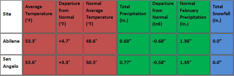
Table 1: February Climate Data for Abilene and San Angelo.
Additional temperature and precipitation data for Abilene and San Angelo is summarized in Table 2.
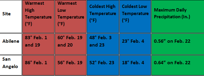
Table 2: Additional February Climate Data for Abilene and San Angelo.
The monthly precipitation varied from above to well-below normal in February (Figure 2).
Figure 2: Percentage of Normal Precipitation for February.
The monthly precipitation was above normal across parts of Throckmorton County in the northeastern Big Country, and across parts of the Northern Edwards Plateau. The monthly precipitation was less than half of normal across the Big Country around and west of Abilene, and across the Concho Valley from San Angelo west and north. For these areas, monthly precipitation amounts varied under one inch (not shown). Most of the February precipitation occurred with an event late in the month (22nd and 23rd).
Elevated to critical fire weather conditions on the 1st occurred with a combination of well-above normal temperatures, gusty south to southwest winds, and dry air. High temperatures were mostly in the lower to mid 80s. Afternoon relative humidity values dropped into the 10-20 percent range across all except far eastern and southeastern parts of west-central Texas.
With these conditions, a couple of small wildfires (grass fires) occurred. One of the fires burned approximately 200 acres in southeastern Mcculloch County (6 miles north of Voca). The other fire burned an estimated 55 acres in far northern Crockett County (14 miles west-southwest of Barnhart).
As an upper level storm system moved into southeastern Colorado and western Kansas, a Pacific cold front surged east across west-central Texas on the evening of the 1st. Strong, gusty west winds followed passage of this front. Peak wind gusts exceeded 40 mph at numerous locations (Table 3).
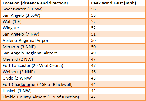
Table 3: Peak Wind Gusts on February 1.
With the exception of one site (San Angelo 3 SSW), all of the peak wind gusts occurred at automated weather stations. These strong winds overturned a mobile home and damaged an outbuilding in Anson (Jones County). Power lines were blown down in the vicinity of the San Angelo Regional Airport. With these west winds, blowing dust was also carried into west-central Texas. Visibility dropped to 5 miles or less, mainly across the Concho Valley and western Big Country.
Gusty west winds continued on the 2nd, but to a lesser extent. A secondary cold front from the north (late on the 2nd) ushered colder air into the region. Highs were in the upper 40s to lower 50s on the 3rd. Temperatures were quite cold on the following night, when high pressure settled into west-central Texas with a combination of clear skies, dry air and light winds. Figure 3, taken from a post on our office Facebook page, shows low temperatures on the early morning of the 4th.
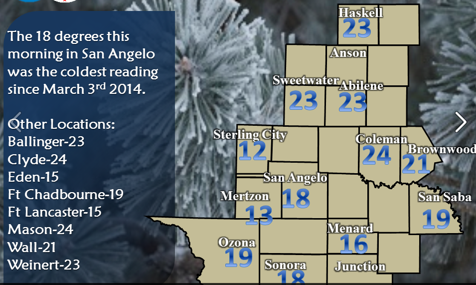
Figure 4: Early Morning Low Temperatures on February 4.
Rather dry airmasses occupied the region during the early and middle parts of the month. With the combination of the dry air and mostly clear skies, large temperature swings in excess of 35 degrees (40 to 50 degrees in some cases) occurred on a number of days, between the early morning lows and afternoon highs. Several weak, dry cold fronts moved into west-central Texas during this time.
Spring-like warmth occurred on the February 17-20, when an upper level ridge of high pressure shifted east across Texas, and south winds prevailed. With windy conditions on the 18th, peak gusts reached 40 mph at some locations, mainly across the Big Country. High temperatures were mostly in the 70s and lower 80s on the 18th to 20th, and lows mostly ranged from the mid 50s to lower 60s on the 19th to 21st. These temperatures were well-above normal for the middle of February. A record high minimum temperature (60 degrees) was tied at Abilene on the 20th.
Showers occurred on the 21st, mainly across the southern half of west-central Texas, with the arrival of a weak upper level disturbance. Rainfall amounts were between one quarter and one-half inch across much of the southern third of the area, and less than one quarter of an inch across the Concho Valley and most of the Heartland.
Showers and thunderstorms were widespread on the night of the 22nd, lingering into the post-Midnight hours of the 23rd. This occurred with an upper level storm system which developed southeast into Texas and strengthened. The stronger storms were accompanied by frequent lightning, gusty winds and locally heavy rainfall. Power outages were reported in San Angelo from lightning strikes, and a peak wind gust of 49 mph was recorded at the San Angelo Regional Airport.
Animated radar imagery shows the track and coverage of showers and thunderstorms across west-central Texas and the surrounding region, between 8 PM and Midnight on the 22nd.
Rainfall amounts for this event are shown in Figure 5.
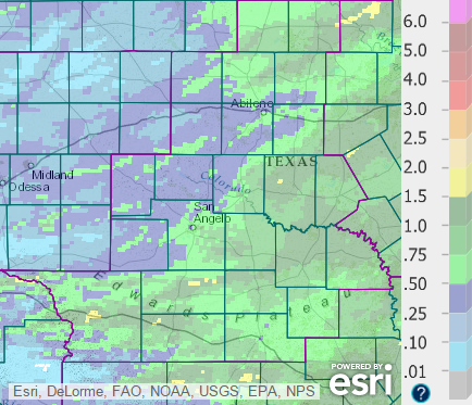
Figure 5: Total Precipitation for the 24-hour period ending at 6 AM, February 24.
The higher rainfall amounts (1-2 inches) occurred at scattered locations across the Big Country north and northeast of Abilene, in parts of the Heartland and eastern Concho Valley, and in parts of the Northern Edwards Plateau into northern Menard County.
Colder temperatures on the 23rd were accompanied by cloudy skies and gusty north-northwest winds, as the storm system moved northeast out of the region. Daytime temperatures were mostly in the 40s. Periodic showers occurred primarily across the Big Country, where additional rainfall amounts varied mostly under one inch.
Skies were mostly clear with a considerably drier airmass on the 24th and 25th, as high pressure moved across Texas. Daily high temperatures were well-above normal on the last few days of the month, with south winds and dry conditions.

