Temperatures averaged near to slightly above normal for the month. Table 1 summarizes August 2016 temperature, precipitation, and departure from normal for Abilene and San Angelo.
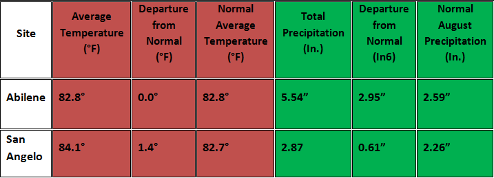
Table 1: August Climate Data for Abilene and San Angelo.
Additional temperature and precipitation data for Abilene and San Angelo is summarized in Table 2.
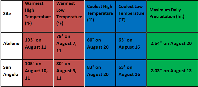
Table 2: Additional August Climate Data for Abilene and San Angelo.
A new record daily precipitation amount (2.03 inches) was set at San Angelo on August 13.
Maps of total precipitation for August (Figure 1) and percent of normal precipitation for the month (Figure 2) are shown below.
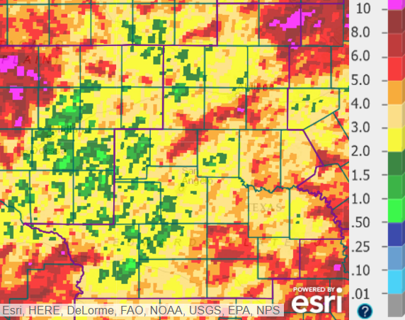
Figure 1: Total Precipitation for August.
August precipitation was between 2 and 5 inches across much of west-central Texas, but the amounts varied widely. The highest monthly precipitation amounts (in excess of 10 inches) occurred in parts of Throckmorton County. Scattered locations received 5-8 inches of rainfall (denoted by red shading). The lowest August precipitation amounts (less than one inch, indicated by light green shading) occurred at a few locations, mainly across western parts of the area.
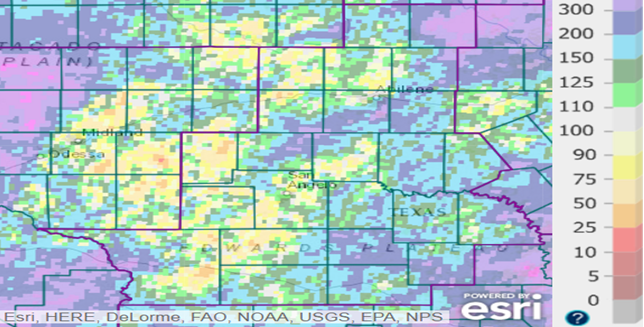
Figure 2: Percentage of Normal Precipitation for August.
The monthly precipitation varied from below to well-above normal. Much of the area with above normal precipitation (denoted by blue and purple shading) was across the eastern half of west-central Texas.
Hot and dry conditions occurred during the first week of August. Afternoon high temperatures were mostly in the 98-103 degree range, while overnight lows were mostly in the mid to upper 70s. An upper level high pressure system was centered over Texas during that time.
The hot and dry conditions from July into August caused the vegetation to become very dry in some areas. Several grass and brush fires occurred, and some of these fires were started by lightning strikes. The location and estimated size of these wildfires is summarized in the table below.
.PNG)
A significant change in the pattern occurred on August 13-15 with notable rainfall, increased cloud cover and cooler temperatures. The upper level high pressure system weakened and allowed a weak cold front to move slowly south into west-central Texas. The combination of a stalling front, a moist airmass and weak upper level disturbances resulted in a few episodes of showers and thunderstorms with heavy rainfall.
During the middle and late parts of the month, upper level high pressure systems were not in close enough proximity to dominate the weather pattern in west-central Texas. On a number of days, showers and thunderstorms occurred in various parts of west-central Texas, with mostly isolated to scattered coverage. Most of this activity occurred during the afternoon and evening hours, and this was mostly caused by weak disturbances aloft combined with sufficient moisture over the area. Some of the reainfall was locally heavy.
Temperatures were closer to normal during the middle and late parts of the month. Although not common for August, a couple of weak cold frontal passages occurred during that time.


 Virtual Tour
 Current Observations
 Weather Briefing
 Satellite Loops
 Past Weather Reports
 Past Rainfall Maps
 Drought Information
 River & Lake Levels
 Fire Weather
 Aviation Weather
 Additional Resources
 Social Media