
Excessive rainfall may produce locally considerable flash flooding over parts of South Texas, the western Gulf Coast, and Lower Mississippi River Valley through Thursday. Hot temperatures will persist over central and northern California and the Pacific Northwest through today. Read More >
Weather and Climate Summary for April 2016
Figure 1 shows the geographic regions across West Central Texas, which are referenced in this summary.

Figure 1: Geographic Regions of West-Central Texas.
Temperatures averaged above normal for the month. Table 1 summarizes April 2016 temperature, precipitation, and departure from normal for Abilene and San Angelo.
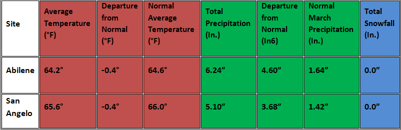
Table 1: April Climate Data for Abilene and San Angelo.
* This was the 7th wettest April on record for Abilene. San Angelo tied its 4th wettest April. *
Additional temperature and precipitation data for Abilene and San Angelo is summarized in Table 2.
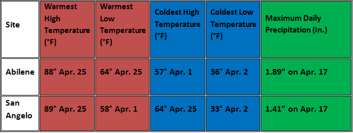
Table 2: Additional April Climate Data for Abilene and San Angelo.
The maximum daily precipitation for Abilene and San Angelo both occurred on April 17. The amounts for both locations set new respective records for maximum daily precipitation for that date. The monthly precipitation for March (Figure 2) and percent of normal precipitation for the month (Figure 3) are shown below.
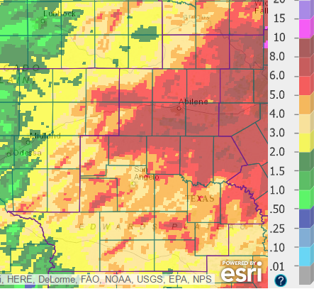
Figure 2: Total Precipitation for April.
Total precipitation for April ranged from 2-3 inches in patchy areas across the southern part of west-central Texas, to more than 8 inches at a few locations between Abilene, San Angelo and Brownwood.
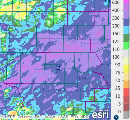
Figure 3: Percentage of Normal Precipitation for April.
The monthly precipitation was well-above normal for nearly all of west-central Texas. This above normal precipitation was brought about largely by an active weather pattern during the middle to late parts of the month, when numerous thunderstorms and thunderstorm complexes produced heavy rainfall.
Cloudy and cool conditions occurred on April 1, with gusty north to northeast winds and some light rain. Daytime temperatures were in the 50s. With clearing skies and decreasing winds, temperatures dipped into the 30s across some of west-central Texas, for early morning lows on the 2nd. Similar low temperatures were recorded on the early morning of the 3rd.
A strong temperature warmup ensued on April 4-5, as an upper level high pressure ridge shifted east into Texas. Highs were in the 80s on the 4th and 5th. After a weak cold frontal passage on the 6th, warm temperatures returned with highs on the 80s on the 7th.
With gusty south winds, moisture returned to the area on the 9th. An area of showers with a few thunderstorms overspread the northern half of west-central Texas during the morning and early afternoon hours, while scattered showers occurred farther to the south. Rainfall amounts for the 9th are shown in Figure 4. The heaviest rainfall (1-2 inches) occurred in a band extending across parts of Sterling, Coke and northern Runnels Counties.
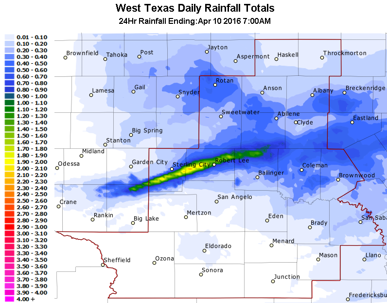
Figure 4: Rainfall for the 24-hour period ending at 7 AM, April 10.
Widely scattered strong to severe thunderstorms occurred on the evening of the 10th. This occurred with the approach of an upper level disturbance from the southwestern states, into a moist and unstable airmass. In Nolan County, golfball size hail was reported 4 miles southwest of Maryneal. Hen egg size hail broke out vehicle windows 3 miles west-northwest of Maryneal. In Tom Green County, quarter size hail and 60 mph wind gusts were reported 3 miles northeast of Wall.
Warm and breezy conditions occurred on the 11th. Following passage of a Pacific cold front in the morning, gusty west winds brought an intrusion of much drier air. Following an overnight cold frontal passage, temperatures were much cooler on the 12th, with cloudy skies.
Showers and scattered thunderstorms occurred on the 12th, with the approach of an upper level disturbance from New Mexico. Rainfall amounts are shown in Figure 5. Rainfall coverage was fairly widespread. The heaviest rainfall (1-2 inches) occurred across parts of the central and western Concho Valley, and at isolated locations in other parts of west-central Texas.
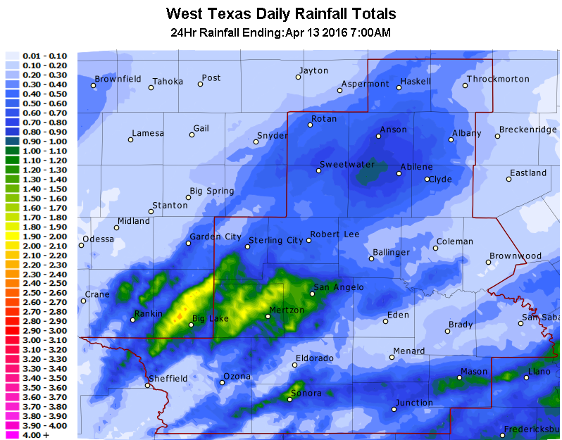
Figure 5: Rainfall for the 24-hour period ending at 7 AM, April 13.
Areas of dense fog occurred on the early morning of the 14th, across roughly the eastern half of west-central Texas. Visibility dropped to less than one quarter of a mile at times. Moisture increased across the area on the 15th, with gusty south to southeast winds.
Heavy rainfall occurred on the 16th and 17th, with flash flooding. A combination of factors led to this event. Some of these factors included a slow-moving upper level storm system over New Mexico, a weak frontal boundary, and rather moist air.
Severe weather occurred across various parts of west-central Texas on April 19-21. Severe weather also occurred on the 26th. Quiet weather occurred on the last few days of the month.

