Wildfire smoke continues to impact air quality from the Great Lakes region into New England and the Mid-Atlantic today with widespread Air Quality Alerts in effect. Severe thunderstorms are expected across portions of the Ohio Valley and Lower Great Lakes into the Mid-Atlantic and Northeast, this afternoon into the evening. Monsoonal thunderstorms may bring areas of flooding to the Southwest. Read More >
| Overview | ||||||||||||||||||||||||
|
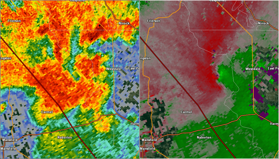
Thunderstorms are nearly a daily occurrence in our region during the summer months. Rich tropical moisture and the summer-time heat provided a great deal of instability to support thunderstorm development. These storms are almost purely driven by daytime heating and will quickly dissipate as the atmosphere cools after sunset. Typically, these thunderstorms are not well organized, and any severe weather is usually in the form of damaging straight-line winds. Southerly surface winds will usually bring a sea breeze front northward from the Gulf of America, which can provide a focus for thunderstorm development. During the overnight and early morning hours of September 2, a large and organized thunderstorm complex developed along the Kansas/Oklahoma state line. Rain-cooled hour rushed outward away from this complex and formed an outflow boundary. This outflow travelled southeast-wards towards the Four State Area over the next several hours. Scattered thunderstorms began to develop by noon on September 2. During the peak of the thunderstorm activity, the southeast-ward moving outflow boundary converged with the northward-moving sea breeze front. This microscale interaction resulted in a local enhancement of low-level wind shear within an already strong thunderstorm. This aided in the development of a tornado that affected portions of De Soto and Red River Parishes. The most notable damage with this tornado occurred at the International Paper Plant northeast of Mansfield, LA. Numerous trees were snapped, a vehicle was flipped in the plant's parking lot, and metal walls and roofs were peeled back on some of the plant's buildings. Cell phone video taken by plant workers and shown on local television stations clearly showed the tornado. Meteorologists from the National Weather Service office in Shreveport surveyed the damage and rated the tornado and EF-1 with peak wind speeds near 95 mph. |
||||||||||||||||||||||||
|
TOTAL TORNADO COUNT = 1
|
||||||||||||||||||||||||
|
Tornado Table
Graphics
Damage Map
Coming Soon! |
||||||||||||||||||||||||
| Back to Top | ||||||||||||||||||||||||