Wildfire smoke continues to impact air quality from the Great Lakes region into New England and the Mid-Atlantic today with widespread Air Quality Alerts in effect. Severe thunderstorms are expected across portions of the Ohio Valley and Lower Great Lakes into the Mid-Atlantic and Northeast, this afternoon into the evening. Monsoonal thunderstorms may bring areas of flooding to the Southwest. Read More >
| Overview | |||||
|
Late in the month of September 2012, it was apparent that a heavy rainfall event was likely to impact portions of the NWS Shreveport County Warning Area. There were several factors in place that would help make this threat a reality from September 29th through September 30th.
One of these factors was a large developing 500 mb trough of low pressure. This trough would take a very favorable track from the southern plains southeastward across southern Arkansas and northern Louisiana. The images at the right show the development and eastward progress of this feature over a 24 hour timeframe from the morning of September 29th through the morning of September 30th. |
||||
|
At the surface, a low pressure system was developing across southeast Texas. Along and ahead of it was a stalled frontal boundary. This surface low and front were to be the main focus for shower and thunderstorm activity for the four state region. Disturbances rotated around the upper level low, helping to initiate several rounds of showers and thunderstorms near these surface features.
As the surface low developed to the southwest, it became very clear that it would track just south of the Shreveport NWS forecast area. This would put areas generally along and south of I-20 in the favored area for heavy rainfall.
The low pressure remained true to the forecast, tracking along a line from near Lufkin, Tx to just south of Alexandria, La. This put areas along and south of a Nacogdoches, Tx to Monroe, La line in the greatest threat for receiving rainfall in excess of 3-5 inches. |
|
||||
|
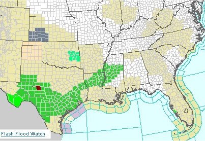
Because of the anticipated threat for very heavy rain and possible flash flooding, a Flash Flood Watch was issued at 4am CDT Saturday, September 29th. Areas included in the watch were in the same area mentioned above, south of a line from Nacogdoches, TX to Monroe, LA. |
||||
|
As predicted, heavy rain fell across areas generally south of I-20. Areas hardest hit were concentrated across East Texa including Angelina, Cherokee, San Augustine, Shelby, Panola, Rusk, Sabine, and Nacogdoches Counties. Rainfall totals exceeded 5 inches in many of these places, as well as numerous locations to the northeast. The heaviest hit areas were across central Nacogdoches County, where more than one foot of rain fell in some spots.
Rainfall totals exceeded 5 inches in many of these places, as well as numerous locations to the northeast. The heaviest hit areas were across central Nacogdoches county, where more than one foot of rain fell in some spots. To see a list of rainfall totals from Saturday through Sunday morning, click here. To see a list of a few of the highest totals from this event, click here. |
|
||||
|
As rainfall totals began accumulating across deep east Texas, forecasters became increasingly concerned about the threat for flash flooding. So, a flash flood warning was issued for areas in east Texas shortly after 10 pm cdt Saturday night. Around 1130 pm cdt, it was reported that a few highways west of Nacogdoches were being covered by rising water. Rain continued to fall through the night and additional reports of flash flooding were reported by local law enforcement and SKYWARN storm spotters, forecasters updated and issued a new flash flood warning shortly after 2 am cdt for some of the same areas in the previous warning, as well as new areas that were now experiencing very heavy rainfall. Heavy rainfall continued through the early morning hours and unfortunately, a woman lost her life. This tragedy happened just south of Chireno, when she and a gentleman drove their car across a flooded roadway. They were swept into a flooded creek and she was unable to escape, while the gentleman was fortunate to get out alive. Remember, driving your vehicle through a flooded roadway is never safe. It can be difficult to determine how deep the water is, as well as the condition of the roadway under the water. This is especially true at night or during low light conditions. Remember, "Turn around, don't drown!" |
|||||