|
|
| 2011 Is Ranked As One of the Warmest Years Ever in Many Locations |
|
Below normal rainfall during the spring and the record heat and extreme/exceptional drought observed throughout much of the summer and early fall of 2011 contributed to above normal monthly temperatures throughout much of the year. Many locations recorded one of the warmest years ever on record.
The table below lists the 2011 average temperature, departure from normal, and how they ranked in history as the warmest year on record.
|
| CITY |
2011 AVERAGE
MONTHLY TEMPERATURE |
DEPARTURE
FROM NORMAL |
RANK |
Shreveport
(records since 1872) |
68.2° F |
+2.5° F |
Tied for 4th
(1927 & 2006) |
Monroe
(records since 1930) |
68.2° F |
+2.4° F |
1st |
Texarkana
(records since 1896) |
66.0° F |
+2.1° F |
Tied for 5th
(2005) |
El Dorado
(records since 1905) |
64.4° F |
+0.9° F |
Tied for 20th
(1945 & 2004) |
Tyler
(records since 1896) |
69.1° F |
+3.7° F |
2nd
(behind 1921 - 69.6° F) |
Longview
(records since 1902) |
68.5° F |
+3.1° F |
Tied for 1st
(1911) |
Lufkin
(records since 1907) |
68.9 ° F |
+2.1° F |
2nd
(behind 1998 - 69.1° F) |
|
| |
| The summer of 2011 will be remembered as the hottest on record for many locations with several sites setting records for both consecutive 100+ degree days and the total number of 100+ degree days. |
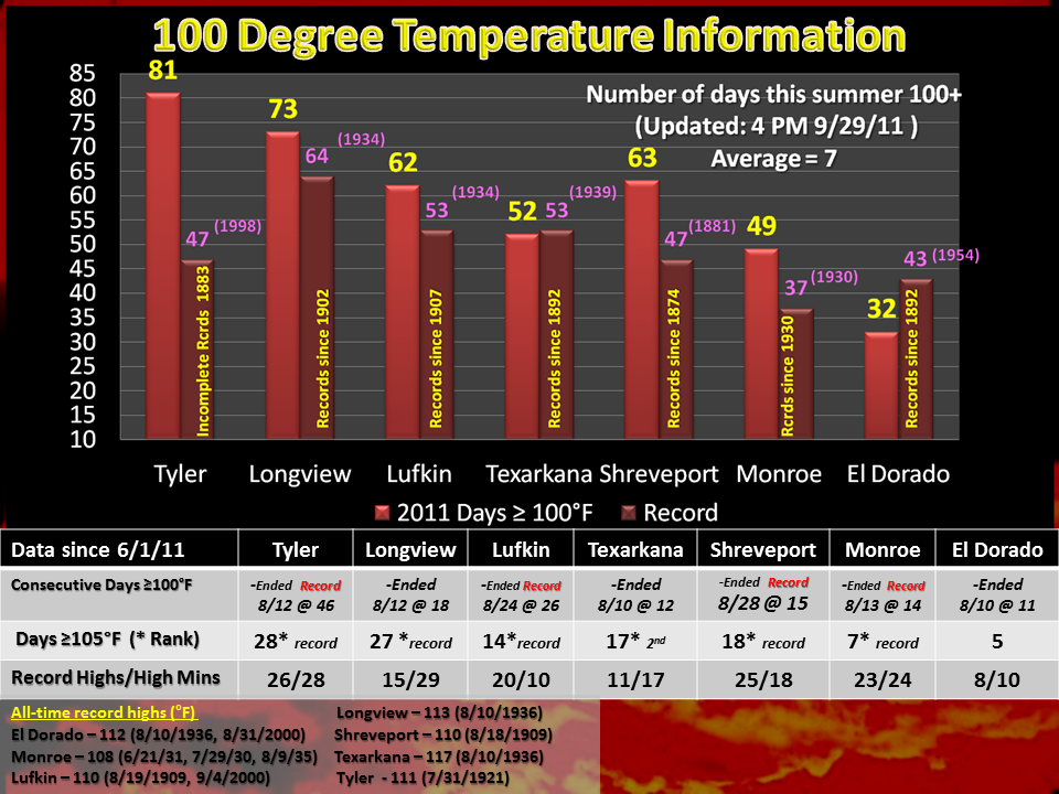 |
| Image showing the number of days above 100 degrees, consecutive day streaks, days above 105 degrees F, and the number of record high/high minimum temperatures broken. |
|
| Back to top |
| |
| Drought Summary |
| 2011 was on pace to become one of the driest years on record. However, a near-normal November and an above normal December, in terms of rainfall, allowed 2011 to drop in the overall rankings. The summer of 2011 will certainly be remembered for how hot and dry it was with several locations recording their driest August and September on record. |
| CITY |
2011 TOTAL
PRECIPITATION |
DEPARTURE
FROM NORMAL |
RANK |
Shreveport
(records since 1872) |
33.07 inches |
-18.34 inches |
17th |
Monroe
(records since 1930) |
49.52 inches |
-4.50 inches |
--- |
Texarkana
(records since 1896) |
30.69 inches |
-18.96 inches |
11th |
El Dorado
(records since 1905) |
37.62 inches |
-15.30 inches |
15th |
Tyler
(records since 1896) |
24.97 inches |
-20.82 inches |
3rd
(24.01 inches in 1956)
(24.92 inches in 2005) |
Longview
(records since 1902) |
30.54 inches |
-17.01 inches |
9th |
Lufkin
(records since 1907) |
33.77 inches |
-15.18 inches |
21st |
|
| |
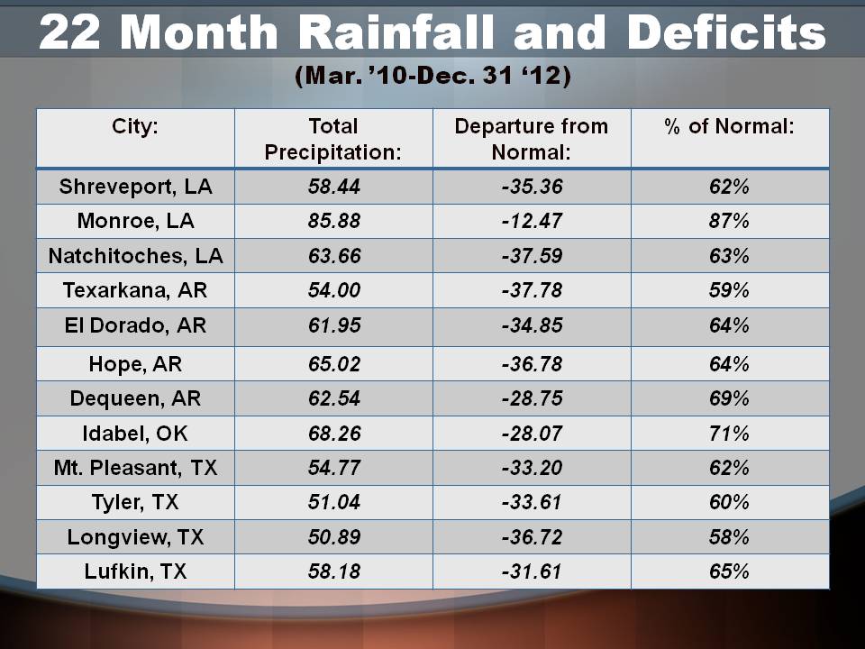
| The drought of 2011 actually started in 2010 and can be traced back to March of 2010. From March 2010 through December 2011, many locations ran large rainfall deficits. The table below is a sampling from many sites across the Four State Region. |
|
|
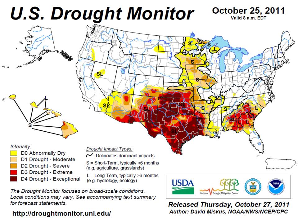
| As a result of the longer term drought, the Drought Monitor was maximized in terms of its severity during late October. The image below is a snapshot from the Drought Monitor in October showing the D4-Exceptional Drought area encompassing most of Texas, Western Louisiana, and portions of Southern Arkansas. |
 |
| Back to top |
| |
| Wildfires |
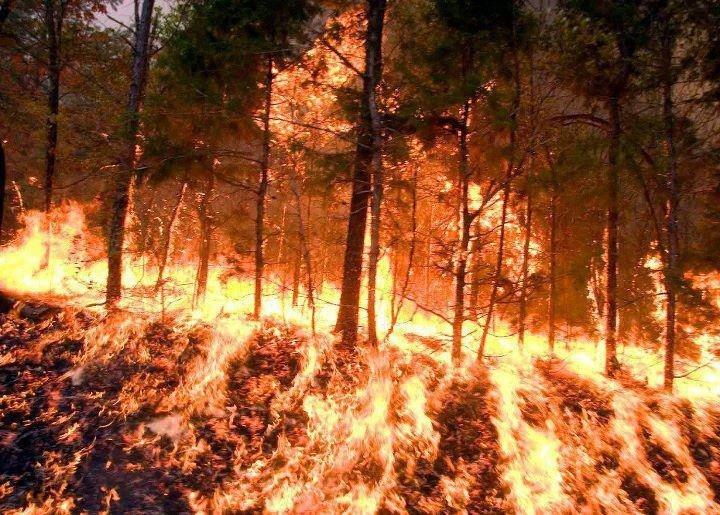
| Over Labor Day Weekend, Tropical Storm Lee made landfall across Southeast Louisiana. As a result, strong winds on the northwest side of Lee brought drier air in from the northeast, which combined with the 100 degree heat to aid in the most explosive wildfire days this area has ever seen. Two people were killed when a fast-moving wildfire in the Gladewater area, and thousands were told to evacuate across many areas due to either the wildfires or the thick heavy smoke, which resulted from the fires. |
| |
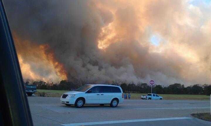
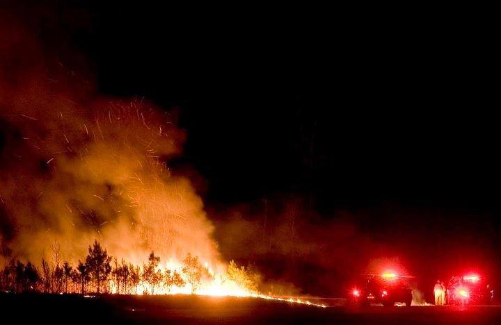
| Pictures from the Cass County - Bear Creek Fire, which burned over 50,000 acres. Photos are courtesy of Dave Hall, Texarkana Office of Emergency Management. |
 |
 |
 |
 |
|
| |
| The Bear Creek Fire was not the only fire to occur in the Four State Region. National Weather Service Storm Data indicates that between May 2011 and October 2011, more than 94,000 acres burned across the region in 55 large wildfires with more than 200 structures destroyed. (National Weather Service Storm Data only includes fires of 150 acres or more OR wildfires, which caused injuries, fatalities, or impacted structures.) There were hundreds of smaller fires (less than 150 acres) across the region in addition to the large fires. In all, approximately 100,000 acres burned across the Four State Region in 2011 as a result of wildfires. |
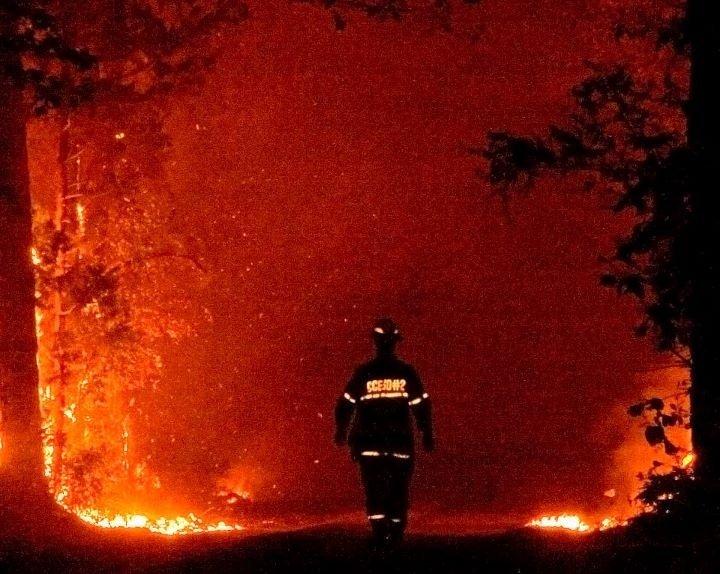
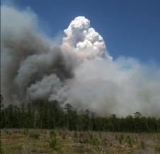
| Pictures from fires in June 2011 in Deep East Texas. |
 |
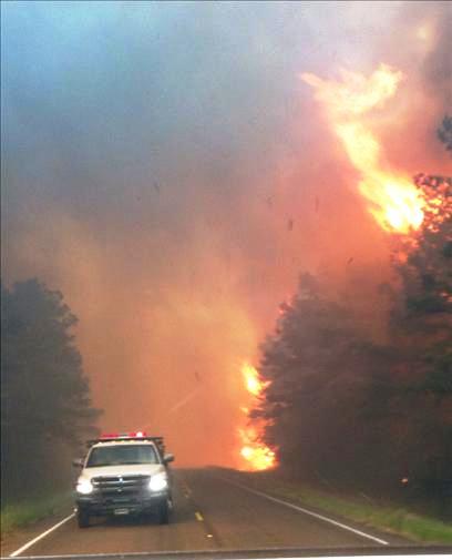 |
|
| |
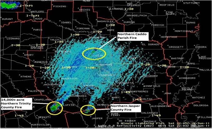
| The smoke plumes became so large on some of the fires that they were clearly visible on both radar and satellite imagery. Fires were also visible on radar imagery due to the large particles within the smoke being lofted thousands of feet into the air over the fires. The NWS in Shreveport issued it's first even Dense Smoke Advisory for portions of East Texas as a result of the thick smoke reducing visibilities along Interstate 20 and other area highways. |
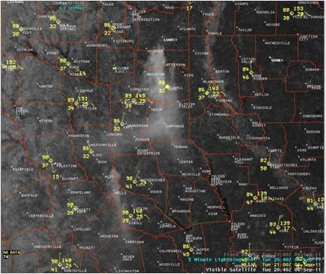 |
| Smoke was clearly visible on satellite imagery in early September when the worst of the wildfires occurred. |
 |
|
Fires were also visible on radar imagery due to the large particles within the smoke being lofted thousands of feet into the air over the fires. The image above is from June 18, 2011. |
|
| Back to top |