National Weather Service United States Department of Commerce
Overview
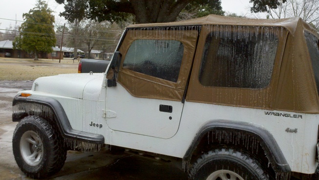
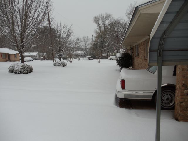
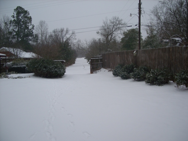
An arctic airmass moved into the region during the week of January 31-February 4, 2011. High temperatures on February 1 and February 2 struggled to get above freezing across most of the region, and each night the temperatures dropped into the teens in most locations.

A large upper level system moved across Texas, tapping into moisture from the Gulf of Mexico and the Eastern Pacific Ocean, and streaming it up and over the cold air in place. As a result, the area received the full gammit of winter weather from significant ice accumulations to heavy snows. Significant ice was reported across the southeastern parishes in Louisiana with a mixed bag across the central portion. Heavy snow fell across northwest portions of the area with amounts ranging from 3 inches to as much as 8 inches in a few locations along the Interstate 30 corridor.

Some impacts from the winter weather included:
  • All schools were closed across the entire 48 county/parish area.
  • Power outages were reported across Natchitoches, Grant, Winn, Caldwell, LaSalle, Jackson, and Ouachita Parishes due to ice on trees and power lines.
  • Numerous auto accidents occurred across the Four State Region. Several highways and overpasses were closed due to icing including the I-220 and I-49 overpasses in Shreveport, the I-30 interchange in Texarkana, and I-20 ramps in Monroe.
 
Snow and Ice Accumulations from February 3-4, 2011
ARKANSAS
LOCATION AMOUNT
Ashdown 4 inches of snow
Athens 4 inches of snow
Bradley 3 inches of snow
De Queen 4.5 inches of snow
3 miles SW of El Dorado 2.5 inches of snow
Fouke 2 inches of snow
Hope 4 inches of snow
6 miles N of Lewisville 5 inches of snow
Magnolia 3 inches of snow
Nashvile 4.5 inches of snow
Prescott 3 inches of snow
Stamps 3 inches of snow
Texarkana Airport 4 inches of snow
Texarkana 6.5 inches of snow
LOUISIANA
Bienville 0.25 inch of ice/
1.5 inches of sleet
Blanchard 4 inches of snow
Colfax 0.5 inch of ice
Coushatta 1 inch of sleet/snow mix
Grayson 0.30 inch of ice
Homer 0.75 inch of ice
Jena 0.90 inch of ice
Jonesboro 0.5 inch of ice
Marion 0.20 inch of ice
Monroe 0.25 inch of ice
Natchitoches 0.60 inch of ice
Oil City 2 inches of snow
Ruston 0.5 inch of ice
Shongaloo 3 inches of snow
Winnfield 0.5 inch of ice
 
Snow and Ice Accumulations from February 3-4, 2011
OKLAHOMA
LOCATION AMOUNT
Broken Bow 3 inches of snow
Valliant 6 inches of snow
TEXAS
Atlanta 2 inches of snow
Big Sandy 2.5 inches of snow
Bogota 5 inches of snow
Carthage 3.5 inches of snow
Center 0.25-1 inch of ice
Daingerfield 5.5 inches of snow
De Kalb 5 inches of snow
Hemphill 0.25 inch of ice
Henderson 2 inches of snow
Gilmer 3 inches of snow
7 miles NW of Jacksonville 2 inches of snow
Jefferson 2 inches of snow
Longview 1.5 inches snow
Lufkin 0.25 inch of ice
Marshall 2 inches of snow
Mineola 2 inches of snow
Mount Pleasant 7 inches of snow
Mount Vernon 6 inches of snow
5 miles E of Mount Vernon 6 inches of snow
9 miles SSE of Mount Vernon 7 inches of snow
New Boston 4 inches of snow
Pittsburg 5 inches of snow
Quitman 4 inches of snow
Tyler 5 inches of snow
2 miles N of Tyler 3 inches of snow
Wake Village 2 inches of snow
Winnsboro 6 inches of snow
Yantis 8 inches of snow
 
Map of reported ice and snowfall accumulations
Reported ice and snowfall accumulations from across the region. Snow is in purple, mix of sleet and snow is yellow, and ice is in blue.
 
 
Ice accumulations in Natchitoches
Ice accumulations in the Natchitoches, LA, area. Photo courtesy of the Emergency Manager.
 
Snow accumulations in the Yantis, TX, area
Snow accumulations in the Yantis, TX, area in
Wood County. Total snow accumulations of 6"-8" were reported. Photo courtesy of John Adams, CBS19.
 
Snow accumulations in the Yantis, TX, area
Photo of the depth of the snow in the Yantis, TX, area. Photo courtesy of John Adams, CBS19..
 
 
Snow covered roads in Bullard, TX
Snow covered roads in Bullard, TX. 3"-4" of snow was reported in this region of Smith County. Photo taken by Ross Hays.
 
Snow covered roads
Snow covered roads were common across the area with temperatures in the mid 20s for 48 hours leading up to the event. Snow, sleet, and freezing rain stuck to everything.
 
4 to 6 inches of snow in Pittsburg, TX
Snow in Pittsburg, TX. Amounts ranged from 4"-6" in this area. Photo is from Mark Disman.
 
Heavy snowfall in De Kalb, TX
Heavy snows in the De Kalb, TX, area in Bowie County where 4 to as much as 7 inches was reported. 5.1" was reported in the city of De Kalb. Photo courtesy of Richard Engle.
 
2 to 3 inches of snow fell in Atlanta, TX
2"-3" of snow was reported in Cass County. This photo was taken in Atlanta, TX, by Jason Patterson.