Snow in the Great Lakes; Critical Fire Weather in the Southwest and Southern Plains
Lake effect snow will continue downwind of the Lower Great Lakes through Wednesday, with accumulations of 4 to 8 inches possible for portions of Upstate New York and the Adirondacks. Gusty winds and dry conditions will result in critical fire weather conditions in the Southwest and Southern Plains Wednesday through Friday. Red Flag Warnings have been issued.
Read More >
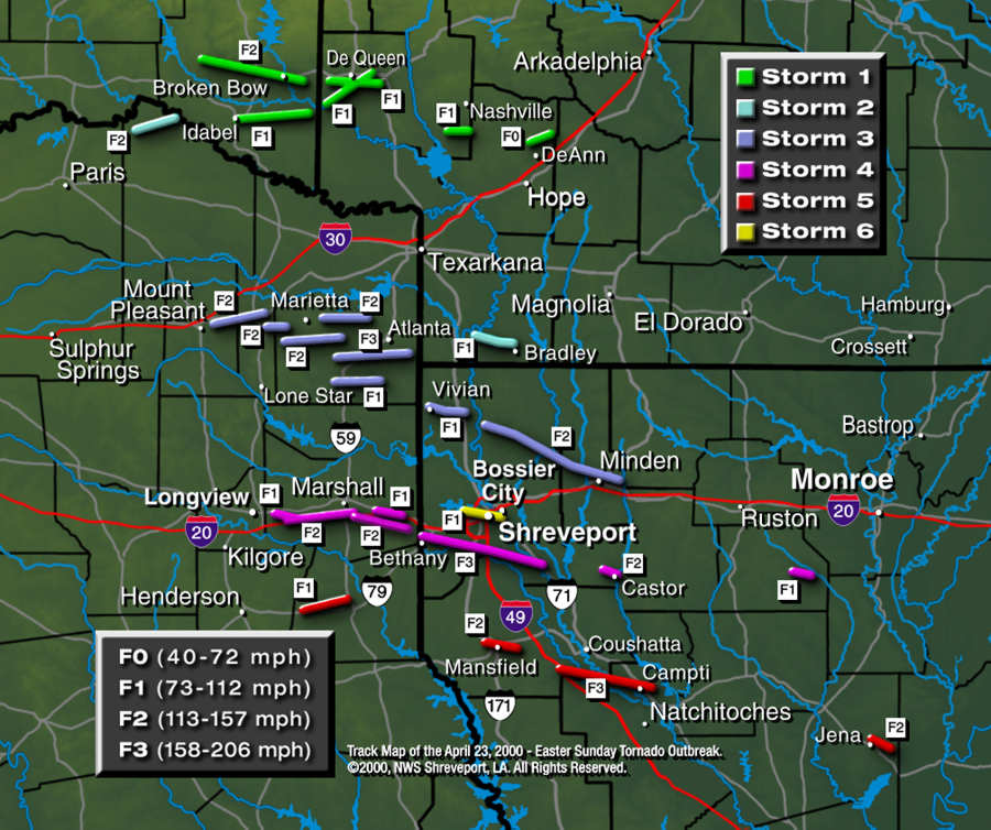
This special section of our web site is devoted entirely to the Easter Sunday Tornado Outbreak that occurred on April 23, 2000. A total of 28 tornadoes (36 tornadic events) touched down within about a 7-hour period. A tornado that crosses a county or parish line is considered two separate tornadic events for record keeping purposes. Areas affected were from McCurtain County in Southeast Oklahoma, through Southwest Arkansas, Northeast Texas, and across Northwest Louisiana. Use the tabs below to explore the details of this phenomenal weather event.
TOTAL TORNADO COUNT = 28
F0 = 2
F1 = 11
F2 = 12
F3 = 3
Fujita Scale
Event Facts
Storm Data
Track Map
Tornado Table
Photos
Graphics
Forecasters and researchers use a wind damage scale created by T. Theodore Fujita to classify tornadoes and sometimes the damage done by other wind storms. The F-Scale, or Fujita Scale, uses numbers from zero to five. The ratings are based on the amounts and type of wind damage. F6 or higher rated tornadoes aren't thought to exist. The damage they would do would be "inconceivable."
The National Weather Service adopted the Fujita Scale for use in 1973 and Allen Pearson, then director of the National Severe Storms Forecast Center, added the Peason Scales for tornado path length and path width, creating the Fujita-Pearson Scale. The following table is the complete Fujita Scale.
More than anyone else in the history of meteorologist, Tetsuya Theodore (Ted) Fujita increased our knowledge of severe storms, especially tornadoes. Here is a brief list of what Tom Grazulis, Director of the Tornado Project, considers to be his most notable achievements. The following text is taken from "The Tornado Project."
Professor Fujita was brought to the United States in the early 1950s by Horace Byers of the University of Chicago. He proceeded to change the course and the speed of severe storm research like no one else in this century. Shortly after his arrival, he began analyzing single thunderstorms the way larger systems had been studied for decades. He saw them as individual weather systems, which he called mesoscale systems.
He introduced the concept of tornado families, which are made up of individual tornadoes, each with a unique path, but spawned by the same thunderstorm. Prior to this, long damage path were usually considered to be made by a single tornado. Through analysis of the photographs of the Fargo, North Dakota, storm, he introduced concepts of thunderstorm architecture and terms like "wall cloud" and "tail cloud." He saw in these storms things that we take for granted today, but it took a genius to see them for the first time.
Tetsuya Theodore Fujita
(1920-1998)
In the 1960s, his analysis of the Palm Sunday Outbreak of 1965 again changed the course of how we view a tornado outbreak. For the first time, he mapped the entire outbreak in terms of tornado families. From the thousands of aerial photographs of Palm Sunday damage, he concluded that there was indeed something special about certain tornadoes, that they must contain more than one vortex. While multiple vortex tornadoes are well known today, he was the first to identify their existence based on damage patterns.
In the 1970s, he again revolutionized tornado climatology by giving us a system that linked damage and wind speed. Previous to this, all tornadoes were counted as equals. Today, the term "F5" is used casually by the general public, and in movies. Without Ted, one can only guess whether there would be any system at all.
The Super Outbreak of 1974 was the pinnacle of his analysis of a tornado outbreak. For many of the 148 tornadoes, he was able to map the entire path in Fujita Scale-intensity contours. Confusing damage patterns from this outbreak would later allow him to identify a new kind of wind storm (see below). He would also mentor a group of students who today are among the leaders in many areas of meteorology. His ability to simplify concepts of severe storms was a great aid in public education, and allowed others to better educated the public. After several decades, we still use his ideas and terminology.
Later in the 1970s, he turned his focus to weather-related aircraft disasters. From this, and his studies of confusing damage patterns in the Super Outbreak, he identified two other phenomena that we take for granted, the downburst and the microburst. Prior to this, meteorologists had been confused by a bewildering array of gusty winds in and around thunderstorms. By the 1980s, the downburst and microburst were being studied as a unique phenomena generated by things such as an intrusion of dry air. At long last, we had a way to distinguish tornado damage from damage by non-tornadic winds.
In his later years, he turned his efforts to hurricanes and typhoons, which was the area of meteorology that he had originally focused on in Japan, where he was born.
Ted's achievements were so fundamental, and so frequent that it is hard to imagine where severe storm meteorology would be today without him. Few people in any science are ever such an accelerating force in their field as was Ted Fujita.
On this page, we have posted some interesting facts about this tornado outbreak, along with damage assessment reports collected from both local offices of the American Red Cross and state offices of Emergency Management. This data is not "official" and IS NOT to be used for insurance or for any other legal purposes.
Interesting Facts
Nearly all of the thunderstorms moved from west-northwest to the east-southeast.
While there were several long-track tornadoes (i.e., more than 10 miles), for the most part, the thunderstorms produced tornadoes with short, intermittent tracks. For example, in Cass County, TX, there were four separate tornado tracks identified, but all four were produced by the same thunderstorms.
On the Fujita Tornado Intensity Scale, most of the storms were rated as F1s and F2s with a few F3s.
With some of the storms, the attendant wind field damage was quite extensive, as much as one to two miles either side of the actual tornado track.
The damage from all of the storms was primarily broken, snapped, or blown over trees.
There was some structural damage caused by the winds, as in the case of the storms that passed over or near Marshall, Shreveport, Minden, and Castor.
There were a number a structures (homes, barns, commercial building, etc.) damaged by the actual winds, but most structures sustained damage from trees, branches, or limbs falling on them.
Storm Damage Assessment
The following lists of information are final as of May 19, 2000. Statistics indicate the number of homes affected in each county/parish, along with known injuries or fatalities. If a particular parish or county is not shown, it is because no reports were received.
LOUISIANA
PARISH
DESTROYED
MAJOR
DAMAGE
MINIMUM
DAMAGE
INJURIES
FATALITIES
Bienville
20
12
28
0
0
Bossier
19
24
70
11
0
Caddo
20
92
464
11
0
DeSoto
1
0
21
0
0
Jackson
1
3
2
0
0
LaSalle
2
11
2
1
0
Natchitoches
2
0
0
0
0
Webster
11
68
65
2
0
Total number of homes affected in Louisiana is 938.
TEXAS
COUNTY
DESTROYED
MAJOR
DAMAGE
MINIMUM
DAMAGE
INJURIES
FATALITIES
Cass
2
6
17
0
0
Harrison
3
11
60
0
0
Total number of homes affected in Texas is 99.
There were no reported injuries.
Although tornado touch downs occurred in McCurtain County, OK and in several counties in Southwest Arkansas, no significant damage was reported.
Overview
Detailed surveys were completed by the National Weather Service in Shreveport, LA. The tornado outbreak began at 2:41pm CDT in northwest Red River County in Northeast Texas and ended at Jena, LA, at 10:00pm CDT. The tornadic thunderstorms that moved through the Four State Area on Easter Sunday started out as a line of thunderstorms ahead of a cold front moving in from Oklahoma. As the line approached the area, a few of the thunderstorms intensified becoming supercell-type thunderstorms. A supercell thunderstorm is a long-lived storm, which contains a rotating updraft. These are very strong, well-developed severe thunderstorms and are the type of storms that produced the tornadoes that moved through the area.
Most of the tornadoes were spawned by six supercell thunderstorms, with a few other thunderstorms producing isolated, but damaging tornadoes. One of these exceptions was the tornado that passed through Downtown Shreveport. This tornado (Storm #6) started as a waterspout over Cross Lake, then became a true tornado as it moved onto land. The thunderstorm that produced this tornado was from a second line of thunderstorms that developed over the area behind the first line of storms.
In this tornado outbreak, the storms generally tracked from the west-northwest toward the east-southeast. Most of the damage tracks were short in length, but four of the tornadoes were on the ground for long tracks. These were:
Northwest Bossier Parish to Minden, LA (37 miles)
Just west of Greenwood to south Shreveport, to Elm Grove, LA (32.5 miles)
Near Wright City to 6 miles east-southeast of Broken Bow, OK (20 miles)
Just southwest of Evelyn to near Campti, LA (19 miles)
Another track of special interest was from Cross Lake, to Downtown Shreveport, to Bossier City, LA (8 miles).
Some of the larger cities and towns directly affected by a tornado on April 23, 2000, included:
North Shreveport, Downtown Shreveport, and Bossier City, LA (F1)
Greenwood, Keithville, and south Shreveport, LA (F3)
Minden, LA (F2)
Mansfield, LA (F2)
Jena, LA (F2)
Castor, LA (F2)
Below is a brief description of each of the six thunderstorms and the tornadoes they produced. This is not complete but does represent a good overview of the storms and a few details. Please refer to the track map for the plotted storm paths and the tornado table for details of each confirmed tornado.
Developed in McCurtain County, OK, and moved into Southwest Arkansas through Sevier, Howard, and Hempstead Counties. Damage noted in or near Idabel and Broken Bow in McCurtain County (F2), near De Queen in Sevier County (F1), near Nashville and Mineral Springs in Howard County (F1) and near DeAnn in Hempstead County (F0).
Developed in Red River County, TX, with damage in extreme northwest portion of the county (F2). It moved over Bowie County, Texas, and Miller County, AR, with no known touch downs. As it moved into Lafayette County in Arkansas it produced a tornado which moved from near Pleasant Hill to near Bradley (F1).
Developed over Titus County, TX, northeast of Mt. Pleasant, moving through Morris and Cass Counties in Texas and into Louisiana over northern Caddo, Bossier, and Webster Parishes, ending in western Claiborne Parish. Damage noted northeast of Mt. Pleasant, TX (F2), north of Omaha and Naples in Morris County (F2), with more intense damage in Cass County (F3) from Marietta to Douglasville. In Louisiana, damage noted from the north side of Vivian to near Hosston in Caddo Parish (F1), in Bossier Parish from between Benton and Plain Dealing across much of the rest of the parish (F2), across much of Webster Parish with the north side of Minden sustaining damage (F2) before finally lifting just short of the Webster and Claiborne Parish line east of Minden. The track of this tornado was 35 to 40 miles long and had an extremely wide damage path, in some cases as much as 4 to 5 miles wide from winds associated with the thunderstorm and tornado.
Was developing over Gregg and Upshur Counties in Northeast Texas and then moved into Harrison County where the tornado first touched down near Harleton then moved towards and through Marshall (F2) and lifted near Waskom. A second tornado touched down on or near the state line between Greenwood and Bethany, LA. It continued across the south side of Shreveport crossing U.S. 171 at Stagecoach Road onto the Southern Trace subdivision, and crossed the Red River north of Caspiana (F2). Moving into Bossier Parish, it crossed U.S. 71 near Atkins and then lifted south of Lake Bistineau (F3). Once the tornado touched down near the state line, it was nearly continuously on the ground for 35 to 40 miles. A third tornado then touched down and moved through Castor in Bienville Parish leaving much of the business section heavily damaged (F2).
The first tornado produced by this thunderstorm first touched down in Panola County, TX, with only minor damage (F1). The storm moved into DeSoto Parish, LA, with damage noted on the north side of Mansfield and north of Rambin (F1). The storm moved on across southern Red River Parish (F1) and into Natchitoches Parish (F3) where it lifted near Campti. This storm took one last swipe at the area when it produced a short-lived tornado that touched down in Jena in LaSalle Parish before ending (F2).
This is the secondary thunderstorm which formed behind the supercells that passed through earlier. This storm produced a waterspout over Cross Lake, which then moved eastward and became a tornado as it moved onto land, moved through Downtown Shreveport, and crossed the Red River into Bossier City (F1).
This data is not "official" and IS NOT to be used for insurance or for any other legal purposes.
TOR. #
START POINT
END
POINT
RATING
START TIME
END TIME
LENGTH/
WIDTH
FATALITIES/
INJURIES
REMARKS
#1
2 miles SSW of Kanawha, Red River County, TX
2.4 miles NE of Blakeney, Red River County, TX
F2
2:41pm CDT
3:11pm CDT
12.5 miles/
75 yards
None
The tornado moved across farm land and wooded areas with few structures or homes present. The county sheriff, his deputy, and a farmer were talking when the tornado, which was described as a long tube, moved out of the woods to their east and crossed within several hundred yards to their north.
#2
1.3 miles SE of Wright City, McCurtain County, OK
6.2 miles ESE of Broken Bow, McCurtain County, OK
F2
3:08pm CDT
3:35pm CDT
20.1 miles/
50 yards
2 injuries
Numerous trees were toppled and broken. The tornado was described as rope-like by storm chasers in the area during most of its path. A house on the south side of Oak Hill was split in half from a fallen tree. The tornado moved through downtown Broken Bow and through a Wal-Mart store. The tornado was F0 intensity as it moved through Broken Bow and F2 near Oak Hill.
#3
2.5 miles E of Mount Pleasant, Titus County, TX
4.2 miles NNE of Naples, Morris County, TX
F2
3:53pm CDT
4:28pm CDT
16.8 miles/
150 yards
None
Small to moderate pine and oak trees were snapped and broken. A mobile home dealership in Cookville, TX, was moderately damaged and several homes suffered shingle loss. Several barns were damaged, but the tornado stayed mostly across rural farmland and forests.
#4
2.2 miles SE of Idabel, McCurtain County, OK
7.8 miles NE of Haworth, McCurtain County, OK
F1
3:58pm CDT
4:43pm CDT
17.2 miles/
75 yards
None
Numerous trees were toppled and stripped. No homes or structures were in the path of this tornado.
#5
3 miles N of Daingerfield, Morris County, TX
6.8 miles NNE of Hughes Springs, Cass County, TX
F2
4:10pm CDT
4:27pm CDT
7.0 miles/
200 yards
None
Numerous large pine and oak trees were snapped and broken. A roof was partially removed from a brick house and a chain link fence was wrapped in a pine tree about 50 feet above the ground.
#6
4.8 miles N of Hughes Springs, Cass County, TX
5.5 miles northwest of Linden, Cass County, TX
F2
4:22pm CDT
4:57pm CDT
11.8 miles/
150 yards
None
Numerous large pine trees and oaks were snapped and broken. No structures were in the path of this tornado.
#7
0.1 mile E of Halllsville, Harrison County, TX
4.5 miles ENE of Hallsville, Harrison County,TX
F1
4:34pm CDT
4:42pm CDT
4.5 miles/
100 yards
None
This tornado occurred in a wooded area and farm land void of structures. Numerous pine and oak trees were snapped and broken.
#8
4.6 miles ESE of Hallsville, Harrison County, TX
2.4 miles WSW of Marshall, Harrison County, TX
F2
4:39pm CDT
5:04pm CDT
10.6 miles/
150 yards
None
Approximately 50 homes and 2 businesses were damaged or destroyed. 17 homes were considered unlivable. Numerous large pine and oak trees were snapped and broken. New eateries, hotels, and home development were underway in this location.
#9
1 mile NE of Cerrogordo, Little River County, AR
3 miles ESE of De Queen, Sevier, County, AR
F1
4:54pm CDT
5:25pm CDT
13 miles/
50 yards
None
Damage consisted of numerous snapped and fallen small trees. The tornado moved through a wooded region away from any population with few structures present. This tornado moved into Sevier County.
In Sevier County, damage consisted mainly of numerous snapped and fallen small trees. Shingles were partially removed from one roof and a swing set was tossed 100 feet at another home.
#10
4 miles ENE of Marietta, Cass County, TX
5.1 miles E of Douglassville, Cass County, TX
F2
4:56pm CDT
5:29pm CDT
14 miles/
150 yards
None
This tornado was one of several which formed over Cass County. It tracked eastward along Hwy 77 and crossed through downtown Douglassville at Hwy 8 then continued east into the woods before lifting. Several homes, mobile homes, and businesses were damaged including the Post Office.
#11
6.8 miles SW of De Queen, Sevier County, AR
4.2 miles SE of De Queen, Sevier County, AR
F1
4:57pm CDT
5:20pm CDT
9.7 miles/
50 yards
None
This tornado occurred over a wooded region with few homes or structures in the area. This tornado was one of two which occurred in the same area around the same time.
#12
5.5 miles SW of Linden, Cass County, TX
0.5 miles NE of Kildare, Cass County, TX
F1
4:58pm CDT
5:29pm CDT
12.5 miles/
75 yards
None
This tornado tracked eastward across wooded territory and farmland. No homes or structures were in the path of this tornado.
#13
3.5 miles NW of Linden, Cass County, TX
5 miles SE of Atlanta, Cass County, TX
F3
4:58pm CDT
5:27pm CDT
16 miles/
880 yards
None
This tornado tracked eastward across wooded territory and farmland. Several barns and two cross-country electrical towers were toppled.
#14
3.1 miles SW of Mineral Springs, Howard County, AR
Tollette, Howard County, AR
F0
5:01pm CDT
5:09pm CDT
3.8 miles/
200 yards
None
Damage was primarily broken and downed trees with one residence suffering minor roof damage.
#15
2.2 miles SE of Scottsville, Harrison County, TX
3.7 miles WNW of Waskom, Harrison County, TX
F2
5:02pm CDT
5:29pm CDT
17 miles/
100 yards
None
Damage was confined to numerous pine and oak trees, which were uprooted and broken. No structures were in the path of this tornado.
#16
1 mile NNW of Vivian, Caddo Parish, LA
2 miles SE of Hosston, Caddo Parish, LA
F1
5:10pm CDT
5:30pm CDT
8 miles/
500 yards
None
Numerous trees were downed along the entire track. Tree damage was noted up to two miles either side of the track. Approximately 25 to 40 residences were damaged by fallen trees. A number of outbuildings were either damaged by trees or wind.
#17
DeAnn, Hempstead County, AR
2.4 miles ENE of DeAnn, Hempstead County, AR
F0
5:25pm CDT
5:30pm CDT
2.4 miles/
200 yards
None
Mainly trees down. Two homes were destroyed from fallen trees. One "open air" barn lost some siding and roofing material.
#18
3 miles SE of Scottsville, Harrison County, TX
3.7 miles WNW of Waskom, Harrison County, TX
F1
5:30pm CDT
5:39pm CDT
5 miles/
100 yards
None
This tornado wen through a wooded with no homes or structures. Numerous pine and oak trees were snapped and broken. This tornado is one of several tornadoes spawned from a high precipitation supercell that moved across Harrison County.
#19
5 miles W of Greenwood, Caddo Parish, LA
4 miles NE of Ninock, Bossier Parish, LA
F3
5:40pm CDT
6:43pm CDT
32.5 miles/
500 yards
3 injuries
Numerous trees and power lines were toppled. Several homes suffered minor to moderate structural damage in the Breckenridge subdivision just southwest of Shreveport. Portable storage building businesses were destroyed and two mobile homes were demolished.
Numerous trees and power lines were downed as the tornado moved across the area. The most extensive damage was noted near Atkins, LA (2.5 miles south of Elm Grove on US 71), where one brick structure was almost totally demolished. Only pieces of two walls remained. The brick structure had 6-inch iron poles supporting the corners and these were bent and twisted. Near the brick building was a two-story house which had its roof completely removed and most of its siding stripped off. A mobile home also on this property was completely destroyed and strewn across the field. Immediately adjacent to this damage, on the other side of US 71, another farm building was completely destroyed along with numerous trees leveled. Eyewitness accounts indicated that two tornadoes occurred with this supercell. Only one injury was reported at this location. A man's arm was lacerated to the bone by flying debris.
#20
7.5 miles SSW of Plain Dealing, Bossier Parish, LA
3.5 miles E of Minden, Webster Parish, LA
F2
5:40pm CDT
6:41pm CDT
37.21 miles/
700 yards
None
Extensive, widespread tree damage along entire track. Tree damage noted up to 2 to 3 miles either side of track. Approximately 25 to 30 residences damaged by fallen trees. A number of outbuildings either damaged by fallen trees or by wind.
About 200 houses in Webster Parish suffered roof damage and numerous trees were either uprooted or snapped. Tree damage occurred up to 1 mile either side of the tornado track.
#21
12 miles W of Carthage, Panola County, TX
5.3 miles WNW of Carthage, Panola County, TX
F1
5:51pm CDT
6:12pm CDT
7 miles/
50 yards
None
This tornado affected a wooded region with no homes or structures. Numerous pine and oak trees were snapped and broken.
#22
1 mile NE of Pleasant Valley, Lafayette County, AR
1.5 miles W of Bradley, Lafayette County, AR
F1
6:28pm CDT
6:45pm CDT
8 miles/
300 yards
None
Farm barns and outbuildings with light to moderate damage, farm trailers were moderately damaged or destroyed, chicken houses were destroyed, numerous trees and power poles were downed, and three mobile homes were damaged.
#23
2 miles NE of Mansfield, DeSoto Parish, LA
6 miles SE of Mansfield, DeSoto Parish, LA
F2
6:48pm CDT
7:07pm CDT
8.5 miles/
150 yards
None
Damage consisted of large pine and oak trees uprooted or snapped. A mobile home was split in half from a fallen oak. Most damage to residences was from fallen trees. A number of outbuildings were damaged by fallen trees and wind.
#24
1.5 miles SSW of Evelyn, DeSoto Parish, LA
1 mile NE of Campti, Natchitoches Parish, LA
F3
7:05pm CDT
8:05pm CDT
19.3 miles/
200 yards
None
Damage consisted mainly of large pine trees snapped and oak trees blown down. Most of the damage to residences was from fallen trees. A number of outbuildings were damaged by fallen trees and wind.
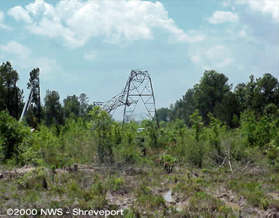
In Natchitoches Parish, two steel utility power towers were destroyed.
#25
5.6 miles W of Shreveport, Caddo Parish, LA
Shreveport, Caddo Parish, LA
F1
7:05pm CDT
7:27pm CDT
8 miles/
150 yards
6 injuries
Nearly 100 homes in Shreveport sustained roof and frame damage. A bus terminal in Downtown Shreveport sustained major damage to windows and its roof. Several downtown buildings had glass winds blown out and roof damage. Numerous trees were completely blown down or snapped.
About 30 homes and businesses in Bossier City sustained roof damage. Several trees were downed and many tree limbs were snapped. Fences were also blown down.
#26
1.3 miles NW of Castor, Bienville Parish, LA
3 miles SE of Castor, Bienville Parish, LA
F2
7:16pm CDT
7:26pm CDT
4.3 miles/
200 yards
None
Several homes and businesses sustained major roof damage. Numerous trees were uprooted and snapped.
#27
Chatham, Jackson Parish, LA
Mount Moriah, Jackson Parish, LA
F1
8:30pm CDT
8:35pm CDT
2.5 miles/
30 yards
1 injury
Damage consisted mostly of several large trees uprooted in town. One old wood frame structure was completely destroyed while similar structures adjacent were untouched. Some shingle damage to homes was also observed. One person was cut by flying glass.
#28
2 miles ENE of Jena, LaSalle Parish, LA
3 miles ESE of Jena, LaSalle Parish, LA
F2
9:05pm CDT
10:00pm CDT
2.3 miles/
150 yards
None
Damage consisted of large pine and oak trees snapped and broken, as well as damage to homes. Most damage to residences was from falling trees. One manufactured home was completely destroyed. A number of outbuildings were damaged by either falling trees or high wind.
The National Weather Service in Shreveport, LA, thanks the following individuals for their photography and video:
Bobby Eddins (professional storm chaser)
Jason Hansford
Bill Parker
Jim Williams
Jason Zahn.
As this supercell was producing the F3 tornado over extreme south Shreveport, it was producing hail up to 4 inches in diameter to the north and east of the wall cloud. This hailstone fell in the Southern Trace subdivision.
Looking west as the storm approached near the Texas and Louisiana state line. The main updraft and rain-free base are evident.
Main updraft and wall cloud, looking toward the west northwest approximately 10 minutes later.
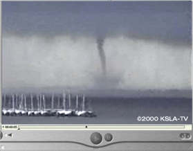
A picture of the wall cloud/tornado.
The wall cloud got robbed of inflow and dissipated as a second funnel formed just to its east (funnel center, old wall cloud left, rain shaft right) along the rear flanking gust front. This shot was taken looking just slightly east of due north.
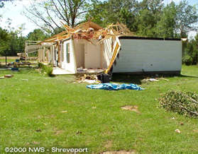
Lancer Lane (off Stagecoach Road) in south Shreveport. The F2 damage shown here is from a mobile home that was tumbled and disintegrated - the frame landed across this car.
Wider view of F2 damage to another mobile home on Lancer Lane in south Shreveport. Note the complete failure of the dwelling and the splintering of the trees in the background.
Frame house almost completely destroyed off of Stagecoach Road in south Shreveport. F1 damage indicated to the structure and nearby trees.
F1 damage to another frame house off of Stagecoach Road in south Shreveport. This roof was completely removed and landed almost intact over 100 yards away.
Major roof and interior damage to this frame house at the corner of Bonanza Trail and Lancer Lane in south Shreveport. This is typical of F0 damage.
F2 damage to another mobile home on Lancer Lane in south Shreveport. There was complete failure of the dwelling with debris tumbled several hundred feet away.
Damage to a mobile home on Bonanza Trail in south Shreveport. Note the severe damage to the home itself, while the front porch was left intact. This is typical of F1 damage.
F2 damage to a frame structure in Castor, LA. The roof has been totally removed along with some interior walls. Heavy damage to contents inside.
F2 damage to a brick structure (Bank of Ringgold) in Castor, LA. The roof was removed and there was substantial interior damage.
F0 damage to the Castor High School. A portion of the roof was torn away, windows were blown out, and there was some interior damage.
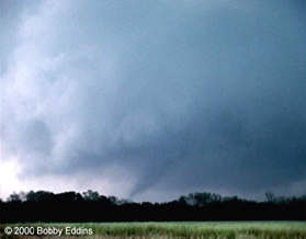
A near-textbook example of the structure of a rotating, supercell thunderstorm. This shot was taken just east of Mansfield, LA, by storm chaser Bobby Eddins.
Shot of the same thunderstorm to the left, but much closer, looking at a large rotating wall cloud on the southwest edge of the thunderstorm.
A tornado descends from the wall cloud just east of Mansfield, LA. Often in this part of the country, this tornado would have been obscured by rain.
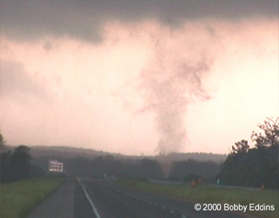
This tornado is growing to maximum width and intensity (F2 status). This tornado will briefly lift and set back down near I-49, southwest of Coushatta, LA.
As viewed from I-49, the "cone" shaped tornado, now an F3 in intensity, is seen in contrast against a clearing sky to the west of the thunderstorm.
F3 damage occurred, mainly to trees, as this tornado continued to move east-southeast to near Campti, LA, before it finally dissipated.
While Bobby Eddins was shooting the "main" tornado from this supercell, a secondary vortex briefly spun up only a few hundred yards away.
This small F0 tornado only lasted about 20 seconds and essentially formed out of nowhere. It demonstrates how dangerous it is to be anywhere under the wall cloud.
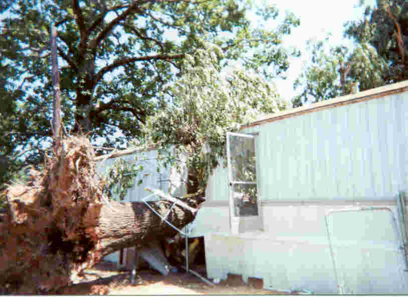
A tornado uprooted a tree in Mansfield, LA, causing considerable damage to a mobile home.
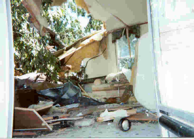
Inside damage of the mobile home
Side view of roof damage to a frame house in Jena, LA.
Front view of the same house shown to the left. This is typical of F1 damage.
F2 damage to an electric high-power transmission tower in Natchitoches Parish. These are made of galvanized steel and requires a substantial tornado to twist them to failure.
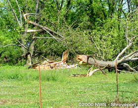
Typical F1 tree damage seen with most of the tornadoes that occurred in this outbreak. Notice the "snapped" and "twisted" nature to the trees. This picture was taken in De Soto Parish..
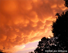
A stunning display of mammatus clouds were observed on the back side of Storm 6 shortly after the storm produced the tornado over Cross Lake and Downtown Shreveport.
While mammatus are not dangerous themselves, they are generally seen in association with mature, severe thunderstorms and are produced by high-altitude downdrafts.
NEXRAD Doppler reflectivity loop of the supercells. The loop starts at 4:20pm CDT and ends at 7:40pm CDT. The increments are approximately every 12 minutes.
Storm 1 - This is the remains of the thunderstorm that produced tornadoes in Southeast Oklahoma and Southwest Arkansas. At the time of this display, it is about to produce the F0 tornado that touched down near DeAnn, AR.
Storm 2 - This is the thunderstorm that produced tornadoes in Northeast Texas in Red River County and is about to produce the tornado that touched down west of Bradley, AR.
Storm 3 - The thunderstorm that started in Titus County, TX, moved across Cass County, TX, and produced the tornado that touched down in Vivian, LA, and moved across Caddo, Bossier, and Webster Parishes before ending just east of Minden, LA.
Storm 4 - This is the thunderstorm that moved over Marshall, TX, and Shreveport, LA, before hitting Castor, LA.
Storm 5 - This thunderstorm is just in the development stage and will produce tornadoes from De Soto Parish to LaSalle Parish.
This is a close-in view of the reflectivity "hooks" associated with supercell Storms 3 and 4. "Hook echoes" of this magnitude typically indicate strong rotation and tornadoes.
Velocity display of Storm 4 and the tornado it produced which moved across the south side of Shreveport. The light green blocks are pixels of inbound velocities (i.e., air moving towards the radar site). The lighter red pixels are outbound velocities. The close proximity of the two opposite direction velocities is indicative of near "gate-to-gate" shear associated with a strong tornado.
This reflectivity image shows the "hook" shaped echo of the tornado moving over Castor, LA (Storm 4), while back over Shreveport, the "hook" echo of the tornado which moved over Downtown Shreveport (Storm 6) can be seen in the second line of thunderstorms that moved through the area.
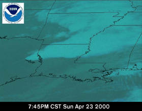
Satellite Images
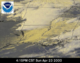
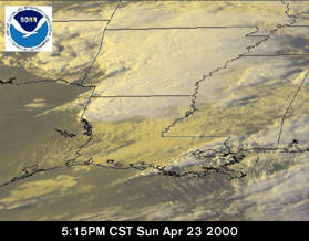
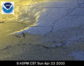
All images were taken from the GOES-8 satellite and are all visible shots with the exception of those that were taken after sunset. All satellite imagery was provided by NOAA - The National Oceanic and Atmospheric Administration.
Visible GOES-8 image from 5:45pm CST, April 23, 2000.
Visible GOES-8 animation loop from 1:15pm to 8:14pm CST, April 23, 2000.
The following series of images are still shots taken from the above animation at intervals of 30 minutes, beginning at 1:15pm CST on April 23, 2000.