Life-Threatening Flash Flooding in South Central Texas; Heat Continues from the Northern Plains to the Mid-Atlantic
Life-threatening and locally catastrophic flash and urban flooding is expected across portions of south-central Texas through early Friday, with significant river flooding and rapid rises on small streams, arroyos, and typically dry washes expected. A significant heat wave continues for the Rockies, Northern Plains, and Great Lakes into the Mid-Atlantic, peaking in intensity through midweek.
Read More >
On April 3, 1999, an outbreak of severe thunderstorms led to several strong tornadoes across portions of East Texas and Northwest Louisiana. Meteorological conditions were primed for the possibility of a significant tornado outbreak. In the upper levels of the atmosphere, a deep trough combined with a strong upper jet streak would provide lift necessary for thunderstorm development. Middle and lower level winds were more than sufficient to support the development of supercells. A pre-frontal trough at the surface would provide a low-level lifting mechanism to initiate storm development. The atmosphere was highly unstable throughout the day and became instability increased during the afternoon hours. Winds veered with height in the lowest few thousand feet, while surface winds had a tendency to back ahead of the pre-frontal trough. This wind shear is key for the development of rotating updrafts and tornadoes.
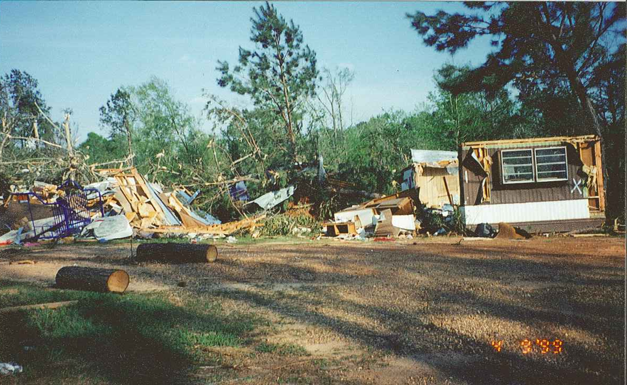
The most significant tornado occurred in Caddo and Bossier Parishes and devastated the town of Benton, LA. Seven people were killed and 112 others sustained injuries. This tornado was rated as F4.
Details from the individual tornadoes are listed in the summary table below.
TOTAL TORNADO COUNT = 4
F3 = 3
F4 = 1
Tornado Table
Meteorological Overview
Photos
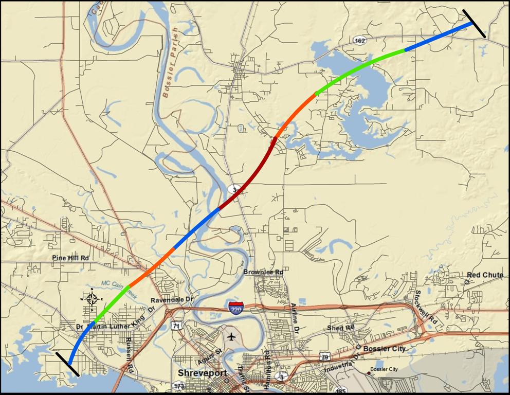
Benton Tornado Track
TOR. #
START POINT
END
POINT
RATING
PEAK WIND
START TIME
END TIME
LENGTH/
WIDTH
FATALITIES/
INJURIES
REMARKS
#1
2 miles SE of Joaquin, Shelby, County, TX
3 miles NE of Logansport, DeSoto Parish, LA
F3
158-206 mph
3:51pm CST
3:59pm CST
5.4 miles/
150 yards
1 injury
In Shelby County, a few homes and outbuildings sustained minor roof damage, but most of the damage consisted of uprooted or snapped trees.
In DeSoto Parish, numerous homes sustained moderate to severe damage. Some wood frame homes lost all exterior walls with roofs partially or completely removed, but with interior walls still standing. A church steeple was knocked over and a portions of the roof was removed. Numerous trees were uprooted or snapped.
#2
6 miles N of Shreveport Regional Airport, Caddo Parish, LA
8 miles ENE of Benton, Bossier Parish, LA
F4
206-260 mph
3:52pm CST
4:20pm CST
19.3 miles/
200 yards
7 fatalities/
112 injuries
This tornado first developed over Cross Lake in Caddo Parish. It moved northeast, causing minor to moderate roof damage to numerous homes and overturning an 18-wheel truck. A steel-framed hardware store was destroyed, and damage was also sustained by other industrial units and Southern University. A total of 66 structures were damaged. The tornado continued northeast and crossed the Red River into Bossier Parish.
In Bossier Parish, the tornado hit the Hay Meadow Mobile Home Park destroying about 100 mobile homes. It then continued northeast to Cypress Lake and dissipated. Some 389 structures were affected. Of this, 227 homes or businesses suffered either major damage or were completely destroyed. Roofs were removed and brick homes were leveled. One brick home was totally missing, leaving only the slab. Numerous large oak and pine trees were uprooted or snapped near their bases.
#3
5 miles SW of Athens, Claiborne Parish, LA
4 miles NE of Athens, Claiborne Parish, LA
F3
158-206 mph
4:58pm CST
5:08pm CST
8.5 miles/
200 yards
None
Two mobile homes were completely destroyed, and two cars were levitated and rolled. About 10 homes were heavily damaged. Numerous large trees were uprooted or snapped.
#4
8 miles SSW of Summerfield, Claiborne Parish, LA
8 miles NE of Summerfield, Claiborne Parish, LA
F3
158-206 mph
5:15pm CST
5:30pm CDT
14.5 miles/
600 yards
None
About 15 homes were severely damaged. Numerous large trees were uprooted or snapped.
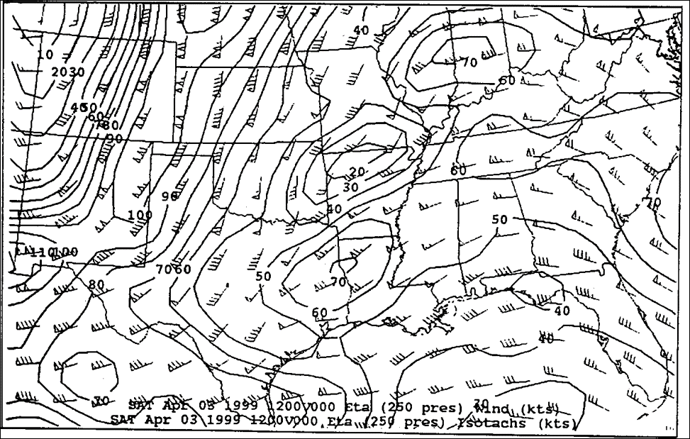
250mb Upper Air Analysis
500mb Upper Air Analysis
250mb (35,000 ft) Analysis (Jet Stream) at 12z on April 3, 1999.
500mb (19,000 ft) Analysis (Heights & Vorticity) at 12z on April 3, 1999.
Important Features:
Upper level jet stream axis across the Southern Rockies.
Jet streak of 70 kts across Northeast Texas and Northwest Louisiana.
Favorable region of upper level divergence (necessary to provide lift in the atmosphere).
Important Features:
Deep trough of low pressure across the Four Corners Region.
Strong ridge of high pressure across the Eastern U.S.
Darker areas embedded in the trough represent areas of vorticity (favorable areas for lift).
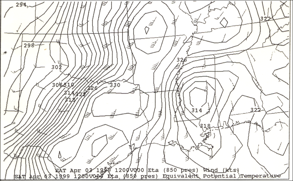
700mb Upper Air Analysis
850mb Upper Air Analysis
700mb (10,000 ft) Analysis (Upward Vertical Motion Field)
at 12z on April 3, 1999.
850mb (5,000 ft) Analysis (Wind Field & Thermal Field)
at 12z on April 3, 1999.
Important Features:
Dotted line represents area of best upward motion.
Solid lines represent downward vertical motion.
Upward motion coincides well with divergence alot at 250mb (35,000 ft).
Important Features:
Low level jet of 45 kts evident across Northeast Texas and Northwest Louisiana.
Thermal axis extends from Central Texas, through Northeast Texas, Northwest Louisiana, and Southwest Arkansas.
Jet hints that strong shear is present in the lower atmosphere and the thermal axis is indicative of a boundary at that elevation.
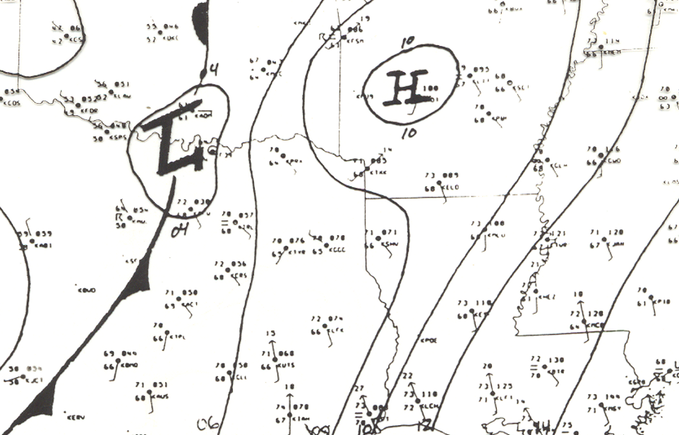
Surface Analysis at 8:00am
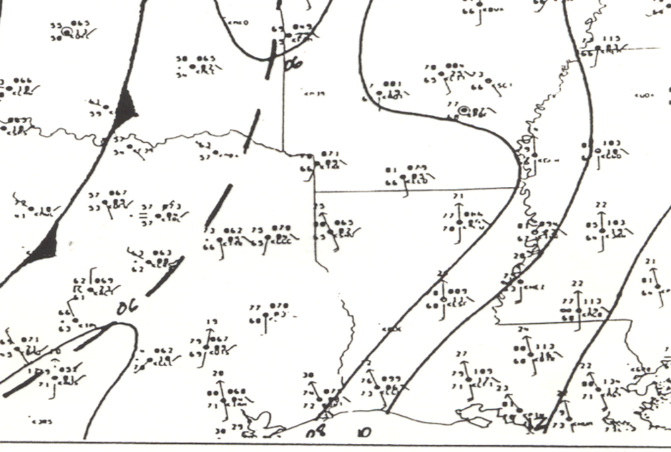
Surface Analysis at 12:00pm
Surface Analysis at 8am on April 3, 1999.
Surface Analysis at 12pm on April 3, 1999.
Important Features:
Unstable environment already present in the morning (7 hours before tornadic thunderstorm development).
Morning temperatures in the 70s, with dewpoint temperatures in the upper 60s. (Abundant low level moisture already present.)
Surface cold front to the west.
Important Features:
South winds increased dramatically (15 to 20 mph sustained with gusts to 25 mph).
Temperatures warming into the 80s, dewpoints rising into the 70s.
Cold front remains stationary but a pre-frontal trough has developed across Northeast Texas. Storms will develop on this boundary.
Track map of the Benton tornado from April 3, 1999.