Severe thunderstorms are forecast through this weekend along a slow moving cold front and secondary storm system that will impact areas from the southern Plains to the Great Lakes. Large hail and isolated damaging wind gusts are the main threats with these storms along with a risk for heavy to excessive rainfall which could bring flooding. Read More >
2021 Arctic Outbreak
Event Summary
During the week of February 8-15, 2021, a cold front crossed the region and ushered in cold air from the Arctic into the southern Plains and our entire region. This air mass was reinforced by an Arctic High across the northern Plains that slipped southward toward the area and continued to reinforce cold air from the north. This was one of the coldest air masses to ever reach the region and for some locations it was the coldest ever. Temperatures warmed into the 70s and even 80s in ArkLaTex ahead of the front, but air temperatures in the -10s and -20s in the northern Plains and Upper Midwest were beginning to spill southward across the Plains. After Wednesday, February 10th, temperatures got cooler and cooler each day across the area, eventually dropping below freezing by Saturday, February 13th and remained below freezing across many areas until Thursday, February 18th and for some locations Friday, February 19th.
In the first phase of this event, the area encountered two minor freezing drizzle events on the morning of Friday, February 12th again on Saturday, February 13th. These events led to minor icings on bridges and elevated roadways each day. I-49 north of Shreveport was closed on Friday, February 12th in anticipation of the freezing drizzle event Saturday morning, February 13th.
During the early hours of Sunday, February 14th, the first of two major winter storms began to push into the region, bringing a mix of snow, sleet, and freezing rain to the area, with the heaviest snowfall occurring Sunday night into the morning hours of Monday, February 15th. Following the first of two winter storms, Tyler (-6°F) and Longview (-5°F) recorded their coldest temperatures ever during the morning of Tuesday, February 16th with Shreveport breaking its daily record by 19 degrees with a low of 1°F. This record led to widespread water main breaks and major pipe bursts from southwestern Arkansas to northwestern Louisiana and westward into East Texas and Deep East Texas.
By the evening hours of Tuesday, February 16th, the second of two winter storms began to push into the area from the northwest. This event brought a more confined corridor of heavy snow to northeast Texas and southwestern Arkansas, but also brought substantial amounts of sleet and ice to areas along and south of the I-20 corridor. The combination of the record cold and both winter storms left power outages in central Louisiana from ice, water shortages across much of the area, and roads impassable across many locations until Friday, February 19th. By the time the second winter storm exited the area, locations in southwestern Arkansas and northeast Texas reported as much as 18-22 inches of snow from the two events combined. Further south to the I-20 corridor, most areas were impacted with at least 4 inches of snow, sleet, and ice covering roads. A quarter to a half inch of ice accumulation in Deep East Texas, central Louisiana, and the Ark-La-Miss, leading to extensive power outages for these areas. Recovery during the event was slow as treacherous roads slowed recovery crews from fixing water main breaks and restoring power.
Graphic 1 - Storm total snow and sleet accumulations from February 14th to February 17th, 2021.
Following the second winter storm, motorists became stranded across the area and I-20 was shut down for several extended periods from February 17th through February 20th. In addition to motorists becoming stranded, cold air continued to be pumped into the area with temperatures dropping into the teens and single digits during the early morning hours of February 18th, 19th, and 20th. On the morning of February 20th a freezing fog event led to rime ice developing across much of the area along with more black ice in addition to refreezing roads. Finally, after one more morning of a refreeze with black ice in some locations, temperatures warmed into the 60s and 70s on Sunday, February 21st and much of the snowpack was able to thaw with exception to the deepest snowpack in southwestern Arkansas which did not fully melt until several days later.
Record-Breaking Cold Temperatures
Many low temperatures records were broken during the Arctic Outbreak. Tuesday, February 16th was the coldest morning for many locations with most of our area shattering the daily record low. Tyler (-6°F) and Longview (-5°F) broke their all-time record lows for any date, 22 degrees colder than the previous daily records for these locations. Shreveport dropped down to 1°F, breaking the previous daily record by 19 degrees.
Graphic 2 - Low temperatures on the morning of February 16, 2021.
...PRELIMINARY EXTREME LOW TEMPERATURE REPORTS FEB 16 2021...
Location Temp Time/Date Lat/Lon
...Arkansas...
...Columbia County...
4.8 SW Stephens (UPR) 1 F 0750 AM 02/16 33.38N/93.14W
...Hempstead County...
6.5 W Hope (UPR) -9 F 0550 AM 02/16 33.64N/93.70W
1.0 E Perrytown (UPR) -7 F 0605 AM 02/16 33.70N/93.52W
...Howard County...
Nashville -14 F 0627 AM 02/17 COOP OBS
...Lafayette County...
Buckner (UPR) -7 F 0630 AM 02/16 33.36N/93.43W
9.0 S Lewisville (UPR) 1 F 0555 AM 02/16 33.24N/93.62W
2.6 E Garland (UPR) 1 F 0535 AM 02/16 33.35N/93.67W
5.7 S Bradley (UPR) 1 F 0410 AM 02/16 33.02N/93.67W
Lake Erling 5 F 0259 AM 02/16 33.05N/93.52W
...Miller County...
8.6 N Fouke (UPR) -3 F 0600 AM 02/16 33.39N/93.89W
Texarkana Regional Webb Fiel -1 F 0653 AM 02/16 33.45N/93.98W
...Nevada County...
Bluff City -5 F 0710 AM 02/16 33.69N/93.16W
1.1 NE Prescott (UPR) -4 F 0630 AM 02/16 33.81N/93.37W
...Union County...
2.1 NW Norphlet (UPR) 3 F 0805 AM 02/16 33.34N/92.68W
El Dorado Goodwin Field Airp 7 F 0753 AM 02/16 33.22N/92.82W
Felsenthal Nwr 10 F 0623 AM 02/16 33.16N/92.19W
...Louisiana...
...Bienville Parish...
Bienville -1 F 0702 AM 02/16 32.25N/92.99W
...Bossier Parish...
Plain Dealing -1 F 0732 AM 02/16 32.91N/93.70W
3.3 S Plain Dealing (UPR) 1 F 0425 AM 02/16 32.86N/93.70W
Barksdale AFB 2 F 0656 AM 02/16 32.50N/93.67W
Haughton 2 F 0645 AM 02/16 32.57N/93.60W
4.3 N Bossier City (UPR) 2 F 0645 AM 02/16 32.59N/93.73W
Shreveport Dwntn 3 F 0653 AM 02/16 32.55N/93.75W
...Caddo Parish...
Blanchard 0 F 0702 AM 02/16 32.61N/93.88W
Shreveport Regional Airport 1 F 0556 AM 02/16 32.45N/93.83W
5.8 N Stonewall (UPR) 1 F 0525 AM 02/16 32.35N/93.83W
12.0 W Hall Summit (UPR) 2 F 0650 AM 02/16 32.24N/93.50W
...Caldwell Parish...
1.1 NE Grayson (UPR) 14 F 0740 AM 02/16 32.06N/92.10W
4.8 N Columbia (UPR) 14 F 0630 AM 02/16 32.17N/92.09W
...Claiborne Parish...
Caney 1 F 0658 AM 02/16 32.80N/93.07W
...De Soto Parish...
Mansfield 3 F 0718 AM 02/16 31.93N/93.89W
...Grant Parish...
Dry Prong 10 F 0756 AM 02/16 31.59N/92.60W
Catahoula 10 F 0643 AM 02/16 31.50N/92.46W
...La Salle Parish...
Tullos (UPR) 10 F 0815 AM 02/16 31.82N/92.33W
Jena 12 F 0722 AM 02/16 31.70N/92.12W
...Lincoln Parish...
Ruston Regional 11 F 0755 AM 02/16 32.52N/92.58W
...Ouachita Parish...
Monroe 16 F 0653 AM 02/16 32.52N/92.03W
...Texas...
...Angelina County...
Lufkin Angelina Airport 4 F 0653 AM 02/16 31.23N/94.75W
...Gregg County...
Longview -4 F 0553 AM 02/16 32.38N/94.72W
...Smith County...
Tyler -3 F 0553 AM 02/16 32.37N/95.40W
...Upshur County...
0.9 S Bettie (UPR) -5 F 0720 AM 02/16 32.80N/94.96W
Gilmer -5 F 0706 AM 02/16 32.70N/94.94W
(A more comprehensive summary of temperature and snowfall records broken during the event coming soon).
Winter Storm #1 - February 14-15, 2021
Graphic 3 - First event total snow and sleet accumulations from February 14th to February 15th, 2021.
...SNOW/SLEET REPORTS...
Location Amount Time/Date Lat/Lon
...Arkansas...
...Columbia County...
Emerson 6.0 in 0754 PM 02/15 33.10N/93.19W
...Hempstead County...
6 SSW Hope 9.0 in 0753 PM 02/15 33.59N/93.65W
Hope 8.0 in 0905 AM 02/15 33.67N/93.60W
...Howard County...
Nashville 7.5 in 0945 AM 02/15 33.95N/93.85W
...Louisiana...
...Bienville Parish...
Arcadia 5.0 in 0754 PM 02/15 32.55N/92.92W
...Bossier Parish...
5 N Plain Dealing 5.0 in 0302 PM 02/15 32.97N/93.69W
...Caddo Parish...
Ida 8.0 in 0755 PM 02/15 33.00N/93.90W
Mooringsport 6.0 in 1142 AM 02/15 32.69N/93.96W
4 S Belcher 5.0 in 0756 PM 02/15 32.70N/93.84W
...Claiborne Parish...
9 SE Shongaloo 5.0 in 0314 PM 02/15 32.84N/93.20W
...Grant Parish...
Pollock 4.5 in 0828 PM 02/15 31.53N/92.41W
...Jackson Parish...
Jonesboro 4.0 in 0130 PM 02/15 32.24N/92.71W
...Natchitoches Parish...
6 WNW Robeline 4.0 in 0830 AM 02/15 31.74N/93.40W
Natchitoches 2.0 in 0800 AM 02/15 31.76N/93.10W
...Ouachita Parish...
West Monroe 3.3 in 0530 PM 02/15 32.51N/92.15W
...Red River Parish...
Coushatta 4.0 in 0744 PM 02/15 32.02N/93.34W
...Webster Parish...
Springhill 6.0 in 1141 AM 02/15 33.01N/93.46W
Sarepta 5.0 in 0859 AM 02/15 32.90N/93.45W
...Oklahoma...
...McCurtain County...
5 NNE America 8.0 in 1056 AM 02/15 33.89N/94.53W
1 SW Idabel 7.0 in 0748 PM 02/15 33.90N/94.83W
Valliant 6.0 in 0739 PM 02/15 34.00N/95.09W
...Texas...
...Angelina County...
Hudson 4.5 in 0738 PM 02/15 31.33N/94.80W
...Bowie County...
1 ESE Texarkana 10.0 in 1045 AM 02/15 33.43N/94.05W
New Boston 9.0 in 0748 PM 02/15 33.46N/94.41W
Hooks 8.5 in 0757 PM 02/15 33.47N/94.28W
Maud 8.0 in 0746 PM 02/15 33.33N/94.35W
De Kalb 8.0 in 0745 PM 02/15 33.51N/94.62W
...Camp County...
Pittsburg 9.0 in 0800 PM 02/15 33.00N/94.97W
4 SW Rocky Mound 6.0 in 0758 PM 02/15 32.99N/95.08W
...Cass County...
Atlanta 7.5 in 0703 PM 02/15 33.12N/94.17W
Hughes Springs 7.2 in 0841 AM 02/15 33.00N/94.63W
...Gregg County...
3 ENE Longview 9.0 in 0800 AM 02/15 32.54N/94.71W
Longview 8.0 in 0451 PM 02/15 32.52N/94.76W
Kilgore 6.0 in 0615 AM 02/15 32.39N/94.87W
...Harrison County...
5 N Marshall 8.0 in 1121 AM 02/15 32.60N/94.34W
Marshall 7.5 in 0800 AM 02/15 32.54N/94.35W
2 SW Marshall 6.0 in 0830 AM 02/15 32.52N/94.37W
...Nacogdoches County...
Appleby 5.0 in 0845 AM 02/15 31.72N/94.61W
Nacogdoches 4.0 in 0900 AM 02/15 31.62N/94.65W
...Panola County...
Carthage 7.5 in 0747 PM 02/15 32.15N/94.34W
...Rusk County...
Henderson 6.3 in 1029 AM 02/15 32.15N/94.79W
4 S Lakeport 6.0 in 0630 AM 02/15 32.35N/94.71W
...Sabine County...
12 SE Hemphill 4.0 in 0836 PM 02/15 31.20N/93.74W
Hemphill 4.0 in 1132 AM 02/15 31.35N/93.85W
...Smith County...
1 N Tyler 9.0 in 0800 AM 02/15 32.35N/95.30W
Winona 8.0 in 0749 PM 02/15 32.49N/95.17W
6 SSW Noonday 8.0 in 0835 AM 02/15 32.16N/95.43W
1 NNW Lindale 7.5 in 0744 PM 02/15 32.51N/95.41W
1 S Tyler 7.5 in 0710 AM 02/15 32.31N/95.30W
Bullard 6.0 in 0800 AM 02/15 32.14N/95.32W
...Upshur County...
1 ESE Bettie 7.5 in 0834 PM 02/15 32.80N/94.95W
1 SSE Bettie 7.0 in 0835 AM 02/15 32.79N/94.95W
...Wood County...
4 WNW Mineola 9.0 in 0759 PM 02/15 32.69N/95.56W
2 N Mineola 8.5 in 0908 AM 02/15 32.70N/95.49W
4 ESE Winnsboro 5.0 in 1237 PM 02/15 32.93N/95.23W
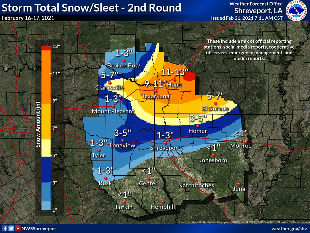
Winter Storm #2 - February 16-17, 2021
Graphic 4 - Second event total snow and sleet accumulations from February 16th to February 17th, 2021.

Graphic 5 - Second event total ice accumulations (from freezing rain) from February 16th to February 17th, 2021. Keep in mind many of the ice accumulations reported below did not represent amounts at the end of the event. In addition, we tracked the extent of power outages to help clarify where it is very likely ice accretions met or exceeded a quarter of an inch.
...SNOW/SLEET REPORTS...
Location Amount Time/Date Lat/Lon
...Arkansas...
...Columbia County...
1 SE Magnolia 6.0 in 0610 PM 02/17 33.27N/93.23W
...Hempstead County...
Hope 11.5 in 0410 PM 02/17 33.67N/93.59W
...Howard County...
1 NNE Nashville 4.0 in 0200 AM 02/18 33.95N/93.85W
...Lafayette County...
Stamps 5.0 in 1220 PM 02/17 33.36N/93.50W
Bradley 3.5 in 0400 PM 02/17 33.10N/93.65W
...Little River County...
1 NW Ashdown 11.5 in 0200 AM 02/18 33.68N/94.13W
Foreman 4.0 in 0321 PM 02/17 33.72N/94.40W
Wilton 3.0 in 0314 PM 02/17 33.74N/94.15W
8 WNW Winthrop 2.0 in 0943 AM 02/17 33.88N/94.47W
...Miller County...
2 SW Texarkana 8.8 in 1200 AM 02/18 33.43N/94.04W
Fouke 8.0 in 0100 AM 02/18 33.26N/93.89W
8 N Fouke 5.0 in 0305 PM 02/17 33.38N/93.88W
4 ESE Texarkana 4.5 in 0339 PM 02/17 33.43N/93.96W
...Nevada County...
1 NW Rosston 14.0 in 0611 PM 02/17 33.59N/93.28W
Prescott 11.8 in 0200 AM 02/18 33.80N/93.38W
...Sevier County...
1 W De Queen 4.0 in 0842 AM 02/17 34.04N/94.36W
De Queen 2.0 in 1200 PM 02/17 34.04N/94.35W
...Union County...
1 WSW El Dorado 7.0 in 0440 PM 02/17 33.21N/92.68W
...Louisiana...
...Bossier Parish...
1 N Bossier City 3.0 in 0100 PM 02/17 32.54N/93.71W
Benton 2.5 in 0800 AM 02/17 32.70N/93.74W
...Caddo Parish...
3 WSW Shreveport 2.5 in 0451 PM 02/17 32.45N/93.84W
...Claiborne Parish...
3.0 S Homer 3.5 in 1245 PM 02/18 32.75N/93.07W
...De Soto Parish...
5 S Stonewall 0.1 in 0831 AM 02/17 32.19N/93.82W
...Webster Parish...
Sarepta 4.0 in 0430 PM 02/17 32.90N/93.45W
...Oklahoma...
...McCurtain County...
1 SW Idabel 2.0 in 0345 PM 02/17 33.90N/94.83W
Smithville 1.3 in 0342 PM 02/17 34.47N/94.65W
...Texas...
...Bowie County...
1 SE Texarkana 10.5 in 0100 AM 02/18 33.43N/94.06W
Texarkana 8.0 in 1053 AM 02/17 33.45N/94.07W
1 ENE Texarkana 6.5 in 0525 PM 02/17 33.45N/94.05W
1 N De Kalb 0.3 in 0755 AM 02/17 33.52N/94.62W
...Cass County...
Atlanta 7.3 in 0715 PM 02/17 33.12N/94.17W
Hughes Springs 5.3 in 1200 AM 02/18 33.00N/94.63W
7 W Linden 3.0 in 0552 PM 02/17 33.00N/94.48W
3 E Atlanta 2.5 in 1026 AM 02/17 33.11N/94.11W
...Cherokee County...
Jacksonville 1.0 in 1000 AM 02/18 31.96N/95.27W
...Gregg County...
White Oak 7.0 in 0945 AM 02/17 32.54N/94.86W
Longview 3.0 in 0212 PM 02/17 32.52N/94.76W
...Harrison County...
Hallsville 2.5 in 0235 PM 02/17 32.51N/94.58W
3 WNW Waskom 1.5 in 1003 AM 02/17 32.50N/94.11W
6 S Scottsville 1.2 in 1159 AM 02/17 32.45N/94.24W
Scottsville 0.4 in 0800 AM 02/17 32.54N/94.24W
...Morris County...
Daingerfield 9.0 in 1032 AM 02/17 33.04N/94.72W
Lone Star 3.5 in 0818 AM 02/17 32.94N/94.71W
...Rusk County...
Henderson 3.0 in 0232 PM 02/17 32.16N/94.80W
...San Augustine County...
Broaddus 15.3 SE 1.5 in 1000 AM 02/18 31.13N/94.11W
...Shelby County...
Center 0.3 in 0835 AM 02/17 31.80N/94.18W
...Titus County...
Mount Pleasant 3.0 in 0901 AM 02/17 33.17N/94.98W
...Upshur County...
6 SW Gilmer 4.0 in 0600 PM 02/17 32.66N/95.02W
Bettie 2.0 in 0850 PM 02/17 32.81N/94.96W
8 W Gilmer 1.0 in 0209 PM 02/17 32.75N/95.09W
...Wood County...
Quitman 2.0 in 0219 PM 02/17 32.80N/95.44W
Mineola 1.0 in 1200 AM 02/18 32.67N/95.49W
...ICE REPORTS...
Location Amount Time/Date Lat/Lon
...Arkansas...
...Union County...
El Dorado 0.10 in 0655 AM 02/17 33.22N/92.66W
...Louisiana...
...Caddo Parish...
3 SW Shreveport 0.13 in 0302 PM 02/17 32.44N/93.83W
...Claiborne Parish...
1 NNW Lisbon 0.10 in 0748 AM 02/17 32.80N/92.87W
...De Soto Parish...
Stonewall 0.10 in 0808 AM 02/17 32.27N/93.82W
...Lincoln Parish...
Choudrant 0.10 in 0255 PM 02/17 32.53N/92.51W
...Ouachita Parish...
West Monroe 0.50 in 1204 PM 02/17 32.52N/92.15W
1 NNE Monroe 0.30 in 0538 PM 02/17 32.53N/92.08W
2 NW Monroe 0.15 in 0110 PM 02/17 32.54N/92.11W
...Sabine Parish...
1 W Zwolle 0.10 in 0755 AM 02/17 31.64N/93.65W
Many 0.10 in 1130 AM 02/17 31.57N/93.48W
...Texas...
...Angelina County...
6 N Hudson 0.38 in 0100 PM 02/17 31.42N/94.80W
6 ESE Wells 0.10 in 0745 AM 02/17 31.45N/94.87W
...Nacogdoches County...
10 SSW Chireno 0.25 in 0933 AM 02/17 31.38N/94.44W
...Smith County...
4 SW Lindale 0.10 in 0819 AM 02/17 32.47N/95.46W