
Thunderstorms, some severe, may produce heavy to excessive rainfall over portions of the Central/Southern Plains, Mississippi Valley and Southeast. Dry and windy conditions will pose an elevated fire weather risk over parts of western Florida. Read More >
What is SKYWARN®?
 SKYWARN® is a National Weather Service (NWS) program of trained volunteer severe weather observers. Weather spotters support their local community and emergency responders by providing the NWS with timely and accurate ground truth reports of severe weather and its impacts. These reports, when integrated with modern NWS technology, are used to inform communities of the proper actions to take when severe weather occurs. The key focus of the SKYWARN® program is to save lives and property through the use of the observations and reports of trained volunteers. Additional information on the program is available on the NWS SKYWARN® Page.
How do I get involved?
Free SKYWARN® spotter training is available online through the MetEd COMET Program. Please note that there is a checkbox to tick after enrolling in the course. That will ensure the NWS receives notice that you have completed the training.
Occasional in-person spotter classes are taught around Western Washington. These classes are typically organized through local emergency management or volunteer organizations. When a public course is available, a headline will be posted on our homepage and the calendar below will be updated.
Further reading is available in the Basic Spotters' Field Guide and the Advanced Spotters' Field Guide.
Skywarn Spotter Training Schedule
This calendar will be updated as additional training becomes available. Pro tip: click on a calendar entry for registration link and to import to your calendar.
What does a SKYWARN® Spotter Report?
| Weather Phenomena | Call The NWS if... |
|---|---|
| Impacts/Damage |
Significant impacts or damage are observed (i.e. impacts to structures, impassable roads, etc.) |
| Wind | 40 mph or stronger |
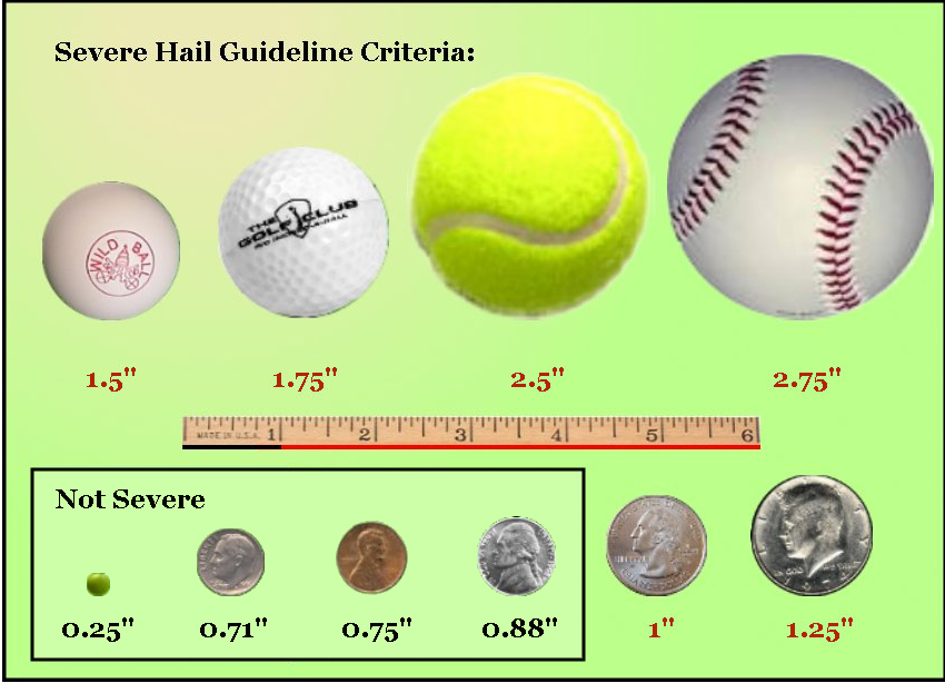
| Hail | 1/2 inch (penny or dime size) or larger in diameter |
| Tornado/Funnel Cloud | Any tornado, funnel cloud, or waterspout. |
| Flooding | Any significant amount of water in normally dry areas |
| River Flooding | Any river rising above their normal bank level |
| Heavy Rain | 1 inch or more within 12 hours OR 1/2 inch or more within 1 hour |
| Heavy Snow | Any snow for the lowlands/coast OR 6 inches or more in the mountains |
| Blowing Snow | When winds are more than 30 mph AND visibility is less than 1/2 mile |
| Freezing Rain | Any freezing rain |
| High Surf or Tides | Any surf or high tides that are causing beach erosion or flooding |
| Geologic Hazards | Any impacts from landslides, volcanic activity, or tsunamis. |
How do I make a report?
Good reports contain a location, details including the time and duration of the impactful event, a photo if available, and callback information.
Via Phone: 206-526-6095 (then use option 1)
Via Twitter: @NWSSeattle (best option if sending a photo/video along with report)
Via Facebook: NWS Seattle
Via Online Form: Submit Storm Report (please note that this method works best when accompanied by a follow-up phone call or for widespread wind/snow events)
CoCoRaHS - How can I share rain & snow reports?
The Community Collaborative Rain, Hail and Snow Network or CoCoRaHS is a non-profit community-based network of volunteers of all ages and backgrounds working together to measure and report precipitation rain, hail, and snow. As most Washington residents know, precipitation can vary greatly with location, topography, storm type and season. CoCoRaHS was developed to supplement existing observation networks, aiding meteorologists, engineers, hydrologists, insurance experts, the media, and many others, in studying the variability of precipitation and in the analysis of extreme precipitation events. More information is available here.
How can I share data from my weather station?
Some weather station data may be shared through the Community Weather Observing Program (CWOP). More information is available here.
For additional information on the SKYWARN® Spotter Program in Western Washington, please contact Dev McMillian.

