U.S. Surf Zone Fatalities 2015 Preliminary data on fatalities which occurred in the surf zones across National Weather Service areas of forecast responsibility through February 16, 2016. This data is preliminary and may not be completely accurate.
|
Rip Current |
High |
Sneaker Wave |
Other |
Not |
Location |
M/F |
Age |
Date |
|
|
X |
Melbourne Beach FL |
M |
64 |
1/4 |
|||
|
|
X |
|
|
|
Thousand Steps Beach, CA |
M |
18 |
2/8 |
|
|
X |
|
|
|
Rincon, PR |
M |
28 |
2/18 |
|
|
|
X |
|
|
Black Sands Beach, CA |
M |
Unk |
3/? |
|
|
|
|
X |
|
Orick Beach CA |
M |
Unk |
3/? |
| X |
St Croix, VI |
M |
60s? |
3/2 |
||||
| X |
Miami Beach, FL |
M |
Unk |
3/13 |
||||
| X |
Vero Beach |
M |
17 |
3/14 |
||||
| X |
St. Augustine, FL |
M |
32 |
3/14 |
||||
| X |
Macarthur Beach SP, FL |
M |
21 |
3/14 |
||||
| X |
Delray Beach, FL |
M |
55 |
3/14 |
||||
|
|
X |
|
|
|
West Coast PR |
M |
35 |
3/18 |
| X |
Plantation Hale, Wailua,Kauai |
M |
72 |
3/21 |
||||
| X |
Mahaulepu Beach, Poipu, Kuai |
M |
48 |
3/22 |
||||
| X |
|
|
|
|
Isabela, PR |
M |
47 |
3/28 |
| X |
|
|
|
|
Dauphin Island, AL |
M |
16 |
4/9 |
| X |
|
|
|
|
Dauphin Island, AL |
M |
16 |
4/9 |
|
|
X |
|
|
|
Caspar Anchorage Bay, CA |
M |
49 |
4/12 |
|
|
X |
|
|
|
Caspar Anchorage Bay, CA |
M |
49 |
4/12 |
|
|
X |
|
|
|
Caspar Anchorage Bay, CA |
M |
53 |
4/12 |
| X |
|
|
|
|
Agate Beach, CA |
M |
34 |
4/17 |
| X |
|
|
|
|
Daytona Beach, FL |
M |
22 |
4/19 |
|
|
|
|
X |
|
Westport, CA |
M |
52 |
4/21 |
| X |
|
|
|
|
Miami Beach, FL |
F |
25 |
5/3 |
| X |
|
|
|
|
Miami Beach, FL |
F |
27 |
5/3 |
| X |
|
|
|
|
Galveston Beach, TX |
M |
23 |
5/9 |
| X |
|
|
|
|
Santa Rosa Island, FL |
M |
20 |
5/11 |
| X |
|
|
|
|
Oak Island, NC |
M |
25 |
5/11 |
| X |
|
|
|
|
Little Talbot Island, FL |
M |
11 |
5/23 |
| X |
|
|
|
|
Myrtle Beach, SC |
M |
20 |
5/23 |
|
|
|
|
X |
|
Myrtle Beach, SC |
M |
60+ |
5/24 |
| X |
|
|
|
|
Daytona Beach Shores, FL |
M |
43 |
5/24 |
|
|
|
|
X |
|
Figure 8 Island, NC |
M |
Unk |
5/25 |
|
|
|
|
|
X |
Little Talbot Island, FL |
M |
Unk |
5/25 |
| X |
|
|
|
|
Melbourne Beach, FL |
M |
50 |
5/25 |
| X |
|
|
|
|
Ormond Beach, FL |
M |
62 |
5/25 |
| X |
|
|
|
|
Sebastian Inlet, FL |
M |
32 |
5/25 |
| X |
Sullivans Island, SC |
M |
23 |
5/25 |
||||
| X |
|
|
|
|
Daytona Beach, FL |
M |
53 |
5/31 |
| X |
|
|
|
|
New Smyrna Beach, FL |
M |
17 |
5/31 |
| X |
Navarre Beach, FL |
M |
20s |
6/17 |
||||
| X |
|
Sterling State Park |
M |
11 |
6/19 |
|||
| X |
|
|
|
|
Garden City SC |
F |
52 |
6/28 |
|
|
|
|
X |
|
North Myrtle Beach, SC |
M |
36 |
7/4 |
|
|
|
|
X |
|
Mantoloking, NJ |
M |
22 |
7/4 |
|
|
|
|
X |
|
North Myrtle Beach, SC |
M |
36 |
7/4 |
|
|
|
|
X |
|
Mantoloking, NJ |
M |
22 |
7/4 |
| X |
|
|
|
|
Joyuda, Cabo Rojo, PR |
M |
53 |
7/11 |
|
|
X |
|
|
|
Zuma Beach, CA |
M |
29 |
7/12 |
| X |
Hutchinson Island, FL |
M |
58 |
7/24 |
||||
|
|
X |
|
|
|
Halano Blowhole, E. Oahu, HI |
M |
21 |
7/25 |
|
|
X |
|
|
|
Halano Blowhole, E. Oahu, HI |
M |
22 |
7/25 |
| X |
|
|
|
|
Myrtle Beach, SC |
M |
16 |
7/28 |
|
|
|
|
X |
|
Emerald Isle, NC |
M |
49 |
7/29 |
| X |
Wendt Cty Park NY (Lake Erie) |
F |
51 |
7/30 |
||||
| X |
|
|
|
|
Porter Beach, IN |
F |
20 |
7/31 |
| X |
|
|
|
|
Long Beach, NY |
M |
23 |
8/1 |
| X |
|
|
|
|
Rogers Beac,h NY |
M |
23 |
8/1 |
|
|
|
|
|
X |
Sandy Hook, NJ |
M |
25 |
8/5 |
|
|
|
|
X |
|
Jupiter Inlet (Dubois Park), FL |
M |
27 |
8/6 |
|
|
|
|
X |
|
Jupiter Inlet (Dubois Park), FL |
M |
15 |
8/7 |
| X |
|
|
|
|
Sea Bright, NJ |
M |
18 |
8/7 |
|
|
|
|
X |
|
Pine Point Beach, ME |
M |
56 |
8/8 |
|
|
|
|
|
X |
Duck, NC |
M |
46 |
8/26 |
| X |
|
|
|
|
Venice Beach, CA |
M |
28 |
9/4 |
|
|
X |
|
|
|
Ocean City, MD |
F |
7 |
9/5 |
|
|
|
|
|
X |
Ocean City, MD |
M |
35 |
9/6 |
|
X |
|
|
|
|
Huntington Beach, CA |
M |
UnK |
9/12 |
| X |
Michigan City Pier, MI |
M |
24 |
9/19 |
||||
| X |
|
|
|
|
Sandbridge, VA |
M |
42 |
9/26 |
|
|
|
|
|
X |
Tybee Island, GA |
? |
? |
9/27 |
|
|
|
|
|
X |
Tybee Island, GA |
? |
? |
9/27 |
| X |
|
|
|
|
Panama City Beach, FL |
M |
31 |
9/27 |
| X |
St. Petersburg Beach, FL |
M |
9 |
10/3 |
||||
| X |
Lumahai Beach, Kaui, HI |
M |
31 |
10/12 |
||||
| X |
Hawaii Kai (Honolulu), Oahu, HI |
M |
21 |
10/24 |
||||
| X |
Shipwreck Beach, Kaui, HI |
M |
60 |
10/24 |
||||
| X |
Kauna Pt St Park, Oahu, HI |
M |
UnK |
10/25 |
||||
| X |
Encinitas, CA |
M |
61 |
10/30 |
||||
| X |
St Joseph (Tiscornia Park), MI |
F |
24 |
11/19 |
||||
| X |
St Joseph (Tiscornia Park), MI |
M |
23 |
11/19 |
||||
| X |
Okaloose Island, FL |
M |
51 |
12/24 |
||||
| X |
Navarre Beach, FL |
M |
28 |
12/29 |
||||
| 41 | 18 | 1 | 16 | 7 |
|
|
|
Total: 83 |
The graphs below show surf zone fatalities documented by NWS Marine and Coastal Services. Accurately tracking these types of fatalities is difficult because so many go unreported and undocumented. Due to the difficult nature of tracking surf zone fatalities; these data may not match other sources.
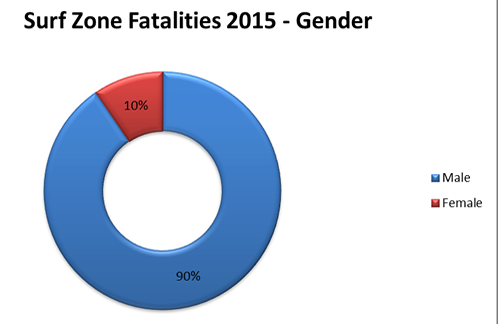
Occasionally, there are surf zone fatalities caused by other hazards such as unusual waves and currents. These hazards fall in the “Other” category. “Other” is not an official category defined by the NWS. Rip Currents cause a large of percentage of the surf zone fatalities in the United States. Typically, a victim of a surf zone hazard is a male between the ages of 10-29. Most of the fatalities occur during the months of June and July and in the NWS Southern Region.
The NWS divides its areas of forecast responsibility into regions shown on the image below. It is rare to have a surf zone fatality in the NWS Alaska Region. The Great Lakes are covered by the NWS offices in the Central and Eastern Region and for the display of these data, all surf zone fatalities in the Great Lakes are categorized into a "Great Lakes Region."
 |
 |
 |
 |
|
|
|
NWS started tracking these statistics in 2013. We do not have breakdowns before 2013.

