National Weather Service United States Department of Commerce
 
Map of US, click for text equivalent
On this page you learn what types of flooding are typical in Washington and how do you protect yourself, your family and your home. You will also find out more about significant Washington floods. Finally, you'll find links to NWS offices that provide forecast and safety information for Washington, as well as links to our partners who play a significant role in keeping you safe

Significant Washington Floods

+May-June 1948

+February 1996

The February 1996 flood was one of the most widespread across the whole Pacific Northwest and Washington: 24 of 39 Washington State counties were affected. A precursor to the event was an extended period of cold temperatures that brought snow to low elevations and created river ice on the east side of the Cascades. Furthermore, the ground was frozen or saturated so subsequent rainfall was directed mostly into runoff. During the week of February 4-10, warm air and excessive precipitation, typical Atmospheric River conditions, and the resultant snow melt caused widespread flooding that continued into the following week. In addition to record precipitation in some of the mountainous areas, melting snowpack across the region contributed as much as half of the total runoff in some locations.
 

The heavy rain and rapid snowmelt combined to produce record and near-record flooding, mudslides, and avalanches. More than 2,600 homes were flooded, dozens of bridges were lost, an estimated $120 million in damages, and 3 fatalities occurred in Washington.

The affected counties were Adams, Asotin, Benton, Clark, Columbia, Cowlitz, Garfield, Grays Harbor, King, Kitsap, Kittitas, Klickitat, Lewis, Lincoln, Pierce, Skagit, Skamania, Snohomish, Spokane, Thurston, Wahkiakum, Walla Walla, Whitman and Yakima. The affected rivers were the Cedar, Chehalis, Columbia, Cowlitz, Klickitat, Naches, Nisqually, Palouse, Skokomish, Skookumchuck, Snoqualmie, Walla Walla, Yakima Rivers; 13 rivers and a creek saw record floods. This flood resulted in the highest flood of record on many southwest Washington rivers, most notably the Chehalis, Skookumchuck, and Nisqually.

Cedar River, Renton. Photo courtesy of King County Snohomish River. Photo courtesy of King County Yakima River. Photo courtesy of Yakima County
Cedar River, Renton.
Photo courtesy of King County
Yakima River.
Photo courtesy of Yakima County
Snohomish River.
Photo courtesy of King County

+November 2006

November 2006 was the wettest November on record, mostly from a single event. A strong, warm and wet Pacific weather system brought copious amounts of rainfall to Washington from November 2 to 7, with subsequent major flooding that extended through November 11. This storm, fueled in part from sub-tropical moisture associated with former western Pacific Typhoon Cimaron, produced rain amounts of between 10 to 38 inches in the Cascades and Olympics and 4 to 10 inches in western Washington lowlands during this period. The mountains had little if any snow pack, so the floods were driven solely by the heavy rainfall amounts.
 

Stampede Pass in the central Washington Cascades received an all-time daily record rain total of 8.22 inches on Nov 6, breaking the old record of 7.29 inches set on Nov 19, 1962. In addition, several other locations broke daily rainfall records. They included SeaTac Airport with 3.29 inches (old record 0.99 inches in 1990), Olympia with 4.31 inches (old record 1.74 inches in 1980) and Quillayute Airport near Forks with 2.38 inches (old record 1.92 inches in 1999). Additionally, June Lake and Swift Creek near Mt St Helens had 24-hour precipitation totals of 15.20 inches and 14.60 inches respectively on Nov 7th. During the overall event, June Lake received 38.20 inches, Swift Creek 36.40 inches and Sheep Canyon 28.00 inches.

The heavy rainfall amounts led to widespread flooding involving nearly all western Washington rivers and four rivers east of the Cascades. NWS Seattle (41), NWS Portland (6), NWS Spokane (1) and NWS Pendleton (4) issued flood warnings for 52 flood warning points throughout the state during the event. In all, 15 western Washington rivers reached all-time record flood crest levels. In addition for smaller streams, urban and small stream flood advisories and areal flood warnings were issued by both NWS Seattle and Portland forecast offices. All streams naturally returned to within their banks by November 11. There was more than $70 million in damages.

The Skagit River at Concrete reached 39.79 ft. or 145,000 cfs, which was only the sevneth highest level in the post-dam era, but nearly 15 ft. above flood stage. That compares with the Grand Daddy Flood in the early 1800s before European settlers, when a flood of around 69.3 ft., 510,000 cfs occurred somewhere around the year 1815, according to the Native Americans living in the area. That is more than 11 times the flood flow of 45,000 cfs, and over 44 feet above flood stage. 

Snoqualmie River November 6, 2006. Photo courtesy of King County Cowlitz River November 6, 2006. Photo courtesy of Lewis County Cowlitz River November 6, 2006. Photo courtesy of Lewis County
Snoqualmie River November 6, 2006.
Photo courtesy of King County
Cowlitz River November 6, 2006.
Photo courtesy of Lewis County
Satellite view of water vapor plume showing Atmospheric
River (aka ”Pineapple Express”)

Learn More:

+December 2007

A series of three storms moved through the Pacific Northwest from Saturday, December 1st, through Monday, December 3, 2007. The storms were the result of a gradual transition from the influence of the northerly storm track to a westerly storm track, which was originating in the subtropics north of Hawaii. The storms combined to bring significant snow to the lowlands and mountains, prolonged strong winds to the coast and mountains, and heavy rain to many areas. The magnitude and impact of the combined events were extraordinary. 

On December 1, a rather cold air mass was in place over Washington that was being maintained by a northerly jet stream plunging southward from Alaska and Canada, resulting in lowland snow. The second system, which was somewhat warmer and wetter, moved onshore late Saturday and early Sunday, generating significant mountain snow and a slow transition from lowland snow to rain. The last of the three systems, which struck the Washington coast early Monday, was the most powerful. It brought tremendous waves, hurricane force winds to the coast for more than 30 hours, and torrential rain to both the lowlands and mountainous areas. That storm was fueled by tropical moisture from the remnants of western Pacific Ocean Typhoons Hagibis and Mitag. Heavy, even record, rainfall combined with the rapidly melting low elevation snow to produce record flooding in western Washington. The 6 hour rainfall amounts were near 100-year event level. The maximum storm total rainfall measured was 19.33 inches in Washington. Record flooding occurred on the Chehalis, Skokomish, Elwha, and Willapa Rivers. 

In addition to the record flooding, major flooding occurred on the Bogachiel River. Flooding also occurred on the Nooksack, Skagit, Stillaguamish, SF Stillaguamish, Snohomish, Skykomish, Snoqualmie, Puyallup, Deschutes, Nisqually, Skookumchuck, Dungeness Rivers and Issaquah Creek. Significant and damaging urban and small stream flooding occurred in Snohomish, King, Lewis, Thurston, Mason, and Kitsap counties when 3 to 8 inches of rain fell over the area. Willapa Hills and southern Olympic mountain areas measured 10 to 20 inches. 

At least 130 people had to be rescued by helicopter. Two men died as a result of river flooding: one near Winlock in Lewis county and another along the Tahuya river in Mason county. A landslide hit a house and buried a man in his sleep near Hoodsport in Mason County. In the headwaters of the Chehalis River, flash flood conditions occurred and whole herds of livestock were lost. The Chehalis River near Doty recorded a record crest that far exceeded a 0.2 percent chance flood (500-year flood). A portion of Interstate 5, the major thoroughfare between Portland and Seattle, was covered by 10 feet of water. As a result, that 20-mile stretch of Interstate 5 was closed for several days, costing the local economy $4 million per day, according to the Washington Department of Transportation. The extreme rainfall also produced more than 2000 large landslides/debris flows causing additional damages and injuries. In total, there was likely over half a billion dollars in damages.
 
Snoqualmie River November 6, 2006. Photo courtesy of King County Cowlitz River November 6, 2006. Photo courtesy of Lewis County
December 4, 2007. Washington Dept. of Transportation.
Landslide near
McCormick, WA.
Flood damage to Interstate 5 near Chehalis,WA on Dec. 4, 2007.
WSDOT photo.
Snoqualmie River November 6, 2006. Photo courtesy of King County Cowlitz River November 6, 2006. Photo courtesy of Lewis County Cowlitz River November 6, 2006. Photo courtesy of Lewis County
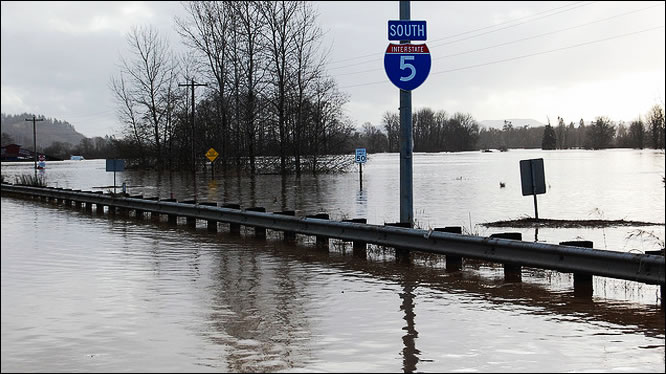
I-5 southbound in Centralia, WA on Dec. 4, 2007.
WSDOT photo by Jim Culp.
Little Bear Creek claims a car as it overtops
Washington State Route 522 near Woodinville.
WSDOT photo by Jim Danninger.
Aerial view of Chehalis/Centralia area,
Lewis County. Washington Dept. of Transportation
photo

Learn More:

+January 2009

A strong, warm and wet Pacific weather system brought copious amounts of rainfall to Washington from January 6 through 8, with subsequent major flooding, that extended through January 11. This storm involved a strong westerly flow aloft with embedded sub-tropical moisture, creating an atmospheric river of moisture into the region. Snow levels rose to between 6000 and 8000 feet. The strong westerly winds aloft enhanced precipitation amounts in the mountains. 

Rain totals in the Cascades and Olympic Mountains ranged from 10 to 20 inches. 3 to 8 inches fell in all the counties of the western Washington lowlands, while east of the Cascades, amounts ranged from 2 to 7.5 inches. On January 7, Olympia set a daily record with 4.82 inches; Quillayute set a new daily record with 2.88 inches and SeaTac Airport had 2.29 inches, a new daily record.

Flooding was widespread over much of western Washington involving nearly all rivers along with urban and small stream flooding, as well as four rivers east of the Cascades. Record flooding occurred on the Snoqualmie, Tolt, North Fork Stillaguamish, and Naselle Rivers. Near record flooding occurred on the Snohomish, Newaukum, and Skookumchuck Rivers. Major flooding occurred on 18 rivers and 21 forecast points. Interstate 5 was closed due to water over the roadway, only the fourth time this has happened since 1990; the primary north-south rail line also was closed. Ice jam flooding was a problem along Hangman Creek in Spokane county. All streams naturally receded to within their banks by January 11.

The heavy rainfall combined with lowland snow melt from the previous cold snap and heavy snow, led to saturated soils helping produce landslides and mudslides.  Highly unstable mountain snowpack produced numerous avalanches. These events would not have nearly as prevalent without the previous cold weather. Numerous highways and local roadways were closed by landslides and mudslides and several dozen homes and structures were impacted. Avalanches closed all the Cascades pass highways. One landslide at Hyak near Interstate-90 knocked down ski lift towers and damaged several homes and buildings.

Surveys found an estimated 497 residences that were destroyed or suffered major damage, and another 2,340 residences that needed repairs. Over 44,000 people were evacuated as a result of rising or high water as well as over 1500 landslides across the state. There was over $72 million in damages over all.
 
Snoqualmie River November 6, 2006. Photo courtesy of King County Snoqualmie River November 6, 2006. Photo courtesy of King County
A mudslide covers Highway 542 near Deming, Wash.
(Photo courtesy of WSDOT)
January 2009 flooding aerial view. Photo courtesy of WSDOT.
Snoqualmie River November 6, 2006. Photo courtesy of King County Snoqualmie River November 6, 2006. Photo courtesy of King County
As reported by Sacramento Bee.
Date is misprinted as 2008 instead of 2009.

Yakima River Flooding January 2009.
West Richland, WA. This is Jones Rd. By
Matt McGee.

Learn More:

Flood Hazard Information

+Flash Flooding

Flash flooding is a rapid and extreme flow of high water into a normally dry area, or a rapid water level rise in a stream or creek above a predetermined flood level, beginning within six hours of the causative event (i.e., intense rainfall, dam failure, ice jam). More information...

+River Flooding

River flooding occurs when river levels rise and overflow their banks or the edges of their main channel and inundate areas that are normally dry. More information...

+Coastal Flooding

At any time of year, a storm from over the ocean can bring heavy precipitation to the U.S. coasts. Whether such a storm is tropical or not, prolonged periods of heavy precipitation can cause flooding in coastal areas, as well as further inland as the storm moves on shore. More information...

+Burn Scars/Debris Flows

Wildfires burn away the vegetation of an area, leaving behind bare ground that tends to repel water. When rain falls, it runs off a burn scar towards a low lying area, sometimes carrying branches, soil and other debris along with it. Without vegetation to hold the soil in place, flooding can produce mud and debris flows. More information...

+Ice/Debris Jams

A back-up of water into surrounding areas can occur when a river or stream is blocked by a build-up of ice or other debris. Debris Jam: A back-up of water into surrounding areas can occur when a river or stream is blocked by a build-up of debris. More information...

+Snowmelt

Flooding due to snowmelt most often occurs in the spring when rapidly warming temperatures quickly melt the snow. The water runs off the already saturated ground into nearby streams and rivers, causing them to rapidly rise and, in some cases, overflow their banks.More information...

+Dry Wash

When heavy rain falls over extremely dry land, the water rushes towards low-lying areas, which may include dried up canyon or river beds. This can quickly turn a dry channel into a raging river.More information...

+Dam Breaks/Levee Failure

A break or failure can occur with little to no warning. Most often they are caused by water overtopping the structure, excessive seepage through the surrounding ground, or a structural failure. More information...
 
Flood Hazard Information                        NWS Forecast Offices and River Forecast Centers (RFC) Covering Washington