On this page you learn what types of flooding are typical in New Mexico and how do you protect yourself, your family and your home. You will also find out more about significant New Mexico floods. Finally, you'll find links to NWS offices that provide forecast and safety information for New Mexico, as well as links to our partners who play a significant role in keeping you safe.
The June 1965 flood event in northeast New Mexico was preceded by an unusually wet spring. Isolated convection produced locally heavy rain in Union and Harding counties on June 14 with a dramatic increase in runoff on the Canadian River. The level of the Conchas Reservoirs rose over 11 feet during the overnight period. On June 16 and 17, an unusually cold and deep closed low aloft combined with low level upslope flow across portions of eastern New Mexico and the east slopes of the Sangre de Cristo Mountains, resulted in a flood of record for tributaries of the Canadian River. The level of the Conchas Reservoir increased another 16 feet. Runoff from tributary waters of the Canadian river caused most of the flood fames, washing out fences, culvers, bridges and roads. The capacity of every culvert and bridge on U.S. Highways 64 and 85 near Cimarron, Raton and Springer was exceeded. Stream flow records indicate that this flood had a recurrence interval greater than 100 years in many areas across eastern New Mexico. On June 17, the peak discharge of the Vermejo River near Dawson was 12,600 ft3/s (a crest of 15.25 feet), which still stands as the peak discharge of record at that station as of 2013.
Two mean died when their truck was swept down Cow Creek south of Raton. Another 28 fatalities occurred just to the north in Colorado. Property damage in New Mexico was estimated to be tens of millions of dollars. The Philmont Scout Ranch sustained significant damage; bridges and roads washed out, and 10, 000 Boy Scouts were stranded in various nearby communities. Agricultural damages included the loss of crops, irrigation systems and livestock. Urban damage in Raton, Cimarron and Springer was substantial.
 |
| The Philmont Scout Ranch sustained significant damage |
The cool season from November 1978 from March of 1979 saw a series of upper level low pressure centers develop off the west coast near Baja California that subsequently produced frequent periods of widespread precipitation in Arizona and western New Mexico. For New Mexico and Arizona, the most damaging event occurred on December 18-19, 1978, when an early season rain event across southern New Mexico produced the heaviest and most extensive rainfall of the period. The warm rain melted snowpack and caused floods in and near the high terrain areas of southwest and south central New Mexico.
Flooding with recurrence intervals of more than 100 years occurred on the Gila River above the San Francisco River. While the record crest at the Gila River near Gila was recorded in the September 1941 event, the third highest recorded crest occurred on December 18, 1978. Many smaller streams ran over and the extensive flooding washed out bridges, inundated farmland, with considerable loss to unharvested crops, and isolated communities. Severe damage was sustained to roads, trails and campgrounds in the Gila Wilderness area. At Redrock, where the Gila River averages a width of 5 to 6 feet, a width of nearly 1 mile was observed during this event.
To the east in south central New Mexico, the Rio Ruidoso and Rio Bonito in southern Lincoln County also experienced flooding on December 19. Many residences were destroyed or damaged, small bridges were washed out, water supplies and sewers were torn up and 30 people were evacuated. There was one fatality.
Former hurricane Dolly brought tropical moisture into New Mexico, producing heavy precipitation as high as 7 inches around Ruidoso. This rain caused the Rio Ruidoso and Rio Bonito to rise well above flood level and widespread, serious flooding occurred from the upper canyon of the Rio Ruidoso downstream through the towns of Ruidoso, Hollywood and Ruidoso Downs as far east as Fox Caves. Flooding also occurred along the Rio Bonito from the dam at Bonito Lake downstream to State Road 48. The flooding was extensive in Ruidoso, not only along the Rio Ruidoso, Cedar Creek and other small streams, but also throughout the town. Local rain reports were 6.3 to 7.0 inches. One man was killed when he was swept away by the raging Rio Ruidoso; no substantial injuries were reported. A total of 500 structures, including campers and mobile homes were damaged. Around 200 houses were damaged, some were completely destroyed. At least 13 bridges were washed out and several cars were washed downstream. Several dozen recreational vehicles and campers were damaged at an RV park at Ruidoso Downs. Damages in Lincoln County along were estimated to be $25 million.
The remnants of Hurricane Dolly also impacted areas in south central New Mexico as the circulation associated with the system moved directly over El Paso, TX, then curved north and northeastward into Otero County. Moisture from this system spread over most of southern New Mexico and lingered another 36 hours. Storm totals from early July 26 into the 27th peaked at more than 4 inches in the Santa Teresa Country Club area, with 2.5 to 3.5 inches of rain to southern Dona Ana County. Water was knee deep in Chaparral, and Highway 28 was flooded south of La Union.
 |
| Damage as viewed in the Ruidoso area |
August 2006 was a wet month across much of New Mexico, with only the far northwest reporting below normal rainfall. A remarkably persistent monsoon regime was in place from late July through most of August that resulted in numerous days of heavy rainfall and flash flooding and record amounts of precipitation in many locations.
Glenwood received about three times the average amount of precipitation, while Albuquerque, Grants, Ruidoso and Deming all received double the average amount of precipitation. StormData lists 91 flash flood events, 5 days with longer-duration, widespread flooding and three fatalities in New Mexico from July 1 through September 15, 2006.
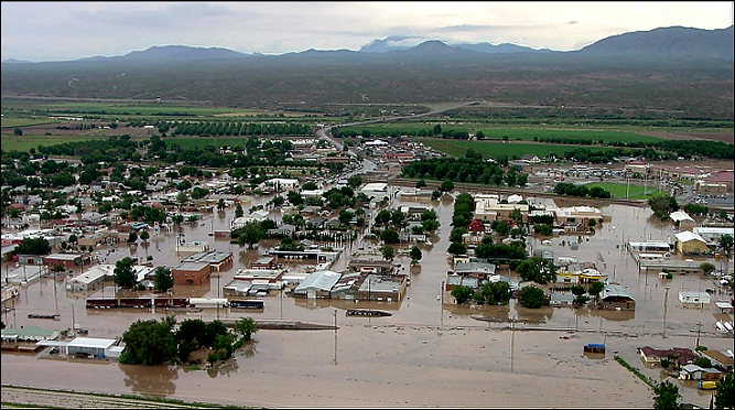
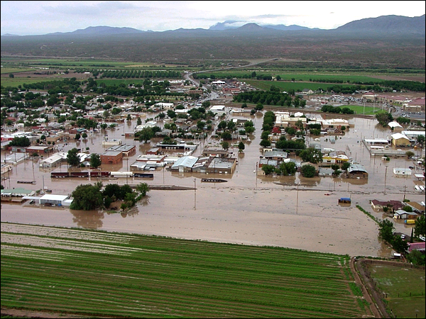
While it is difficult to determine the single most damaging flood event, extensive flooding occurred on August 15 when runoff from heavy rains over the nearby Sierra De Las Uvas Mountains caused the Placitas Arroyo to breach, which sent a wall of water into the town of Hatch. Up to 4 feet of water entered business and residences across a widespread area. Mandatory evacuations of several hundred residents took place, including 150 people from an apartment complex, which eventually had to be condemned. All roads into and within Hatch were closed. Damages exceeded $4 million for this single event.
 |
|
||||||


