National Weather Service United States Department of Commerce
 
Flooding in Indiana

On this page you learn what types of flooding are typical in New Jersey and how do you protect yourself, your family and your home. You will also find out more about significant New Jersey floods. Finally, you'll find links to NWS offices that provide forecast and safety information for New Jersey as well as links to our partners who play a significant role in keeping you safe.

Significant New Jersey Floods

+Passaic River Flood of 1903

+Delaware River Flood August, 1955

Set Up: Back-to-back tropical cyclones in mid-August were responsible for historic and deadly flooding across the Delaware Basin. Rainfall from Connie fell on the 13th. Rainfall from Diane primarily fell on the 18th. Between the two, 10 to 20 inches of rain fell across the basin.

Location Impacted: Homes, businesses, sewer systems, roads and bridges, and livestock and crops were all damaged or destroyed by the high water. Damage extended along the entire length of the mainstem Delaware on the New Jersey and Pennsylvania sides. Northwest portions of the basin in Pennsylvania, were hit the hardest. Major flooding also occurred on Neshaminy Creek, Broadhead Creek, Bush Kill and the Lehigh River.

Number of Fatalities: Heavy rainfall took the lives of 191 men, woman and children. The most lives, 74, were lost in Monroe County, PA. The largest loss of life that occurred in a single location was at Camp Davis, a religious retreat just south of Analomink where 37 people died. The number of fatalities could have been higher. Thanks mainly to Navy helicopters, more than 600 campers were evacuated from three islands within the Delaware River. Boy Scouts were evacuated from Treasure Island. Campfire Girls were evacuated from Pennington Island. Church campers were evacuated from Marshall Island. 

Dollar Damage: The devastation that both Connie and Diane caused went beyond just the state of New Jersey. An estimated $1.6 billion in damages occurred in the Mid-Atlantic and New England Regions. Inflation calculators suggest that equivalent 2013 losses equal more than $14 billion.


 The Great Ohio River Flood of January 1937
Learn More:

+Raritan River Flood 1999

Set Up: On September 16, the remnants of Hurricane Floyd intersected a stalled front and dumped more than 8 inches of rain in 12 of New Jersey's 21 counties. The hardest hit area was the Raritan Basin.

Location Impacted: Eight of the state's 21 counties, accounting for more than half the state's population of 8.4 million at the time, were declared disaster areas: Bergen, Essex, Mercer, Middlesex, Morris, Passaic, Somerset and Union.

Record flooding occurred at four river gages across the Raritan basin. Flood waters crested between eight and 14 feet above flood stage.

Name of Gage/Location Flood Stage Crest
Blackwells Mills 9.0 feet 20.97 feet
Raritan 10.0 feet 18.87 feet
Manville 14.0 feet 25.70 feet
Bound Brook 28.0 feet 42.13 feet

Boundbrook was one of the hardest hit towns; 10 feet of water was measured on Main Street. Power and phone services were interrupted and trucks were brought in to provide fresh water. Schools were closed for weeks. More than 650,000 customers were without electricity at some point. The National Guard was called out to help with recovery efforts. Stranded residents were plucked from houses by helicopters and boats. Approximately 10,000 people were evacuated across the state, 3,500 of those specifically from Boundbrook.

Number of Fatalities: Four

Dollar Damage: Total costs for the region in 1999 were estimated at $3 billion to $6 billion, hundreds of millions specifically for New Jersey. 

+Tropical Storm Irene Flooding 2011

Set Up: Tropical Storm Irene made landfall near the Little Egg Inlet on August 28. Although landfall and the majority of evacuations were across the southern part of the state, rainfall in excess of 10 inches inundated both the Passaic and Raritan Basins; 33 of the 48 forecast points in the Mt. Holly forecast area were flooded. Out of the 12 forecast points in the Passaic Basin, 9 crested in the major category and 3 in the moderate category. All five river forecast points in the Raritan basin experienced major flooding. 

Location Impacted: While all of New Jersey was impacted by Irene, northeast New Jersey took the brunt of the storm. In all, 200,000 homes and buildings were damaged or destroyed. More than 1.5 million customers were without power. More than 31,000 state residents filed assistance claims through FEMA. Hardest-hit counties were Bergen and Passaic, each with more than 4,000 claims.

Number of Fatalities: Six

Dollar Damage: Damage estimates across the state were about $1 billion. Up until Superstorm Sandy, Irene's price tag was the state's costliest.

Learn More:

+October 2012, Superstorm Sandy

Name of Flood/Event: Northeast New Jersey

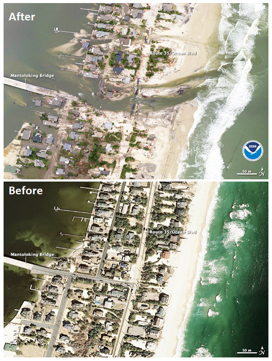
Set Up: Superstorm Sandy's storm surge hit New Jersey on October 29 while making landfall near Atlantic City. Winds gusted to hurricane strength. A full moon and a landfall near high tide amplified impacts. 

Preparations began on October 26, when officials in Cape May County advised residents on barrier islands to evacuate. There was also a voluntary evacuation for Mantoloking, Bay Head, Barnegat Light, Beach Haven, Harvey Cedars, Long Beach, Ship Bottom and Stafford in Ocean County.

As the storm approached, evacuations became mandatory. Governor Christie ordered all residents of barrier islands from Sandy Hook to Cape May to evacuate. He also closed all of the Atlantic City casinos. Tolls were suspended on the northbound Garden State Parkway and the westbound Atlantic City Expressway to aid in the evacuation.

President Obama signed an emergency declaration for New Jersey, allowing the state to request federal funding and other assistance for actions taken before Sandy's landfall.

Location Impacted: Much of the state was impacted one way or another: 509 out of 580 school districts were closed on October 30. Over 2 million customers statewide were without power. While rain and wind were ingredients of Sandy, storm surge had the most impact and was what made Sandy so expensive. The storm surge was felt up and down the New Jersey coast, but the surge along the Monmouth County coast and in Raritan Bay did the most damage. A maximum and record storm surge of 14 feet was recoded at Sandy Hook. Bergen, Hudson, Essex, Union, Middlesex, Monmouth, Ocean, Atlantic, Cape May, Cumberland, Salem, Gloucester, Camden, and Burlington all experienced some level of surge.

Number of Fatalities: 37

Dollar Damage: $68 billion across the U.S. with $30 billion in New Jersey.
 The Great Ohio River Flood of January 1937


Flood Hazard Information

+Flash Flooding

Flash flooding is a rapid and extreme flow of high water into a normally dry area, or a rapid water level rise in a stream or creek above a predetermined flood level, beginning within six hours of the causative event (i.e., intense rainfall, dam failure, ice jam). More information...

+River Flooding

River flooding occurs when river levels rise and overflow their banks or the edges of their main channel and inundate areas that are normally dry. More information...

+Tropical Systems and Coastal Flooding

At any time of year, a storm from over the ocean can bring heavy precipitation to the U.S. coasts. Whether such a storm is tropical or not, prolonged periods of heavy precipitation can cause flooding in coastal areas, as well as further inland as the storm moves on shore. More information...

+Ice/Debris Jams

A back-up of water into surrounding areas can occur when a river or stream is blocked by a build-up of ice or other debris. Debris Jam: A back-up of water into surrounding areas can occur when a river or stream is blocked by a build-up of debris. More information...

+Snowmelt

Flooding due to snowmelt most often occurs in the spring when rapidly warming temperatures quickly melt the snow. The water runs off the already saturated ground into nearby streams and rivers, causing them to rapidly rise and, in some cases, overflow their banks.More information...

+Dam Breaks/Levee Failure

A break or failure can occur with little to no warning. Most often they are caused by water overtopping the structure, excessive seepage through the surrounding ground, or a structural failure. More information...
 
Protect Life and Property                                  NWS Forecast Offices and River Forecast Center (RFC) Covering New Jersey