
On this page you learn what types of flooding are typical in Nebraska and how do you protect yourself, your family and your home. You will also find out more about significant Nebraska floods. Finally, you'll find links to NWS offices that provide forecast and safety information for Nebraska, as well as links to our partners who play a significant role in keeping you safe.
Going into the summer of 1993, much of the eastern and southern Missouri River basin in Iowa, Nebraska, South Dakota, Kansas and Missouri had saturated soil moisture conditions thanks to above average precipitation in the last half of 1992 and the spring of 1993.
By early June a stationary high pressure system stalled over the southeast United States and a stationary low pressure system was over the Northwest. Theese two systems created a boundary or convergence zone where the jet stream, which dipped to the south over the West, was forced in a northeasterly direction through the Midwest. This convergence zone moved back and forth from the Dakotas, Minnesota, and Wisconsin to Kansas, Missouri and Illinois, producing more than twice the normal rainfall in much of the Missouri River basin east of the 100th meridian.
The precipitation was not only heavy but also persistent. Rain fell somewhere in the Missouri River basin every day from March 14 through July 29. From June 1 to July 27, rain fell on 34 of 57 days at Omaha. The most severe flooding since 1952 occurred on the Missouri River from the confluence of the Platte River to the mouth. Within this reach, the river reached record or near record peak discharges from July 23-31. On July 23-24, a record crest of the Missouri River overtopped federal levee L-550 near Brownville. On July 24, the St. Joseph Airport Levee Unit R-471-460 overtopped. On July 26, levee units L-400 and L-246 overtopped.
There were two deaths from the flooding. Additionally, public infrastructure damage totaled $44 million ($71 million in 2013 dollars) and 5.8 million acres of cropland were flooded, resulting in $317 million dollars in damage ($512 million in 2013 dollars).
Learn More:
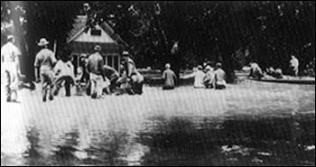
From May to July 1950, south central and southeast Nebraska had four major floods that together claimed 25 lives and caused $65 million in damage ($1 billion in 2013 dollars).
The flood of May 8-9 caused 23 deaths and inundated more than 60,000 acres of land. The flooding was most severe along the Little Nemaha River, Salt Creek, Weeping Water Creek and several tributaries of the Big Blue River. Agricultural land in the river basin upstream from Lincoln was damaged considerably, and six people were killed as a result of the flooding in the Salt Creek basin. The towns of Nehawka, Union and Weeping Water were flooded by Weeping Water Creek, and the town of DeWitt was flooded by Turkey Creek. There wasone death at Union. Flooding was not as severe along the mainstem Big Blue River, but two people died when an automobile was swept from a highway.
The flood of June 2-3 on Beaver, Shell, and Union Creeks in east-central Nebraska was caused by thunderstorms the previous day. Much of the town of Madison was inundated by Union Creek.
The final flood event, July 8-10, was caused by thunderstorms over the headwaters of the West Fork of the Big Blue River. Floods developed on tributaries of the West Fork Big Blue River, particularly Beaver Creek. A large area of York was flooded and most of Beaver Crossing was inundated. Flooding was not as extensive downstream from the confluence of the West Fork and the mainstem of the Big Blue River, but low-lying areas of Crete were flooded, and serious damage extended downstream to Beatrice. The storm also caused flooding along Beaver Creek in the Loup River basin and resulted in one death. Additional flooding occurred on July 18-19 along the Loup River, Shell Creek and Beaver Creek.

Photo Source: Flood of 1950 Scenes: Nebraska Department of Natural Resource

Photo Source: Flood of 1950 Scenes: Nebraska Department of Natural Resource
Learn More:
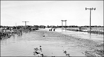
Following a wet year in 1880, the winter of 1880-1881 was marked by below normal temperatures and heavy snows, resulting in an exceedingly heavy snow blanket over the plains area of the upper Missouri River basin. By spring, there was also 24 to 32 inch thick river ice in the vicinity of Yankton and Omaha.
Spring thaws and ice breakup began in the upper basin while the lower river was still frozen, resulting in huge ice gorges in the Dakotas. An ice jam near Yankton was especially devastating and estimated to be over 30 miles long. The resulting snowmelt lead to records river flows from Sioux City to St. Joseph and was the highest on record until 1952. The flood has been blamed for at least three deaths in Nebraska. In addition thousands of head of livestock were killed and several small riverside towns were washed away. The flooding was so bad, the town of Niobrara was moved to a new site on higher ground.
In Omaha, downtown was flooded up to 9th Street, and Council Bluffs also experienced extensive flooding. There were only two deaths in Omaha during the floods. A small one-man skiff was being used by three Union Pacific workers who were attempting to cross a break in a temporary dam when the river’s current pushed it into the main channel. Two of the men jumped from the boat and drowned immediately.
Because this was such a historic flood, it was used as the design flood to build the six Missouri River mainstem dams.

Photo Source: Public Domain (Google) Photo Source: Omaha Public Library
Learn More:
This killer flood followed on the heels of the “Great Republican River Flood” just 12 years earlier in 1935. To help prevent such disasters from happening again, the Medicine Creek Dam was constructed upstream of Cambridge. The dam was built in 1948-49 and has provided decades of protection from potential flood waters, as well as meeting vital irrigation needs in the region.
In central Nebraska, more than 6 inches of rain on June 22 caused floods along the North, Middle, and South Loup Rivers. The Loup River subsequently flooded the low-lying areas of Columbus. Parts of the Elkhorn River basin in northeastern Nebraska also were flooded.
University of Nebraska-Lincoln Photo
Wikipedia: Republican River 1947
Learn More:
|
||||||


