
On this page you learn what types of flooding are typical in North Carolina and how do you protect yourself, your family and your home. You will also find out more about significant North Carolina floods. Finally, you'll find links to NWS offices that provide forecast and safety information for North Carolina, as well as links to our partners who play a significant role in keeping you safe.
Two tropical cyclones wreaked havoc on western North Carolina in July 1916. The first storm, a major hurricane, made landfall on the Gulf Coast of Alabama on July 5. The storm then moved slowly north, producing heavy rainfall over the mountains and foothills of North Carolina as it weakened and dissipated over southeast Tennessee a few days later. This storm produced no flooding, but the ground was thoroughly saturated and streams were running high when the second storm, a Category 2 hurricane, made landfall on the South Carolina coast on July 14. This storm moved west and passed over Charleston and Columbia, reaching the southern North Carolina mountains on the 15th and 16th as a tropical storm. Record rainfall was widespread, with one observer in Altapass, NC, recording 22.22 inches of rain for the 24-hour period from 2 pm, July 15-16.
The flooding resulting from the one-two punch of these cyclones was devastating. The French Broad river, which flows through Asheville and west into the Tennessee river, crested an estimated 17 feet above flood stage. Even higher readings, up to 23 feet above previous high water records, were recorded along the Catawba River, which flows out of the mountains southeast to near Charlotte and into South Carolina. Destruction and loss of life was widespread along both rivers. At least 80 individuals were killed and numerous homes, factories, railroads, and bridges were destroyed. Hundreds of landslides destroyed farms and roads in the mountains.
It is difficult to put a contemporary equivalent dollar value on the damage, but one early account estimates damage at $22 million, which equates to around $500 million in 2013.
|
|
|
|
|
|
|
|
|
|
Learn More:
A widespread major flood event in August 1940 resulted from a landfalling tropical cyclone’s decay and interaction with topography over western North Carolina during mid-August. This widespread and particularly devastating flood is found in many accounts of historic events in local newspaper archives.
The hurricane’s track was particularly conducive to producing extremely heavy rainfall due to slow movement and its initial motion to the west and subsequent northward curl, which maintained deep and moist upslope flow on the eastern slopes of the Appalachians.
The storm produced heavy rain over a 5-day period, from the 12th through the 16th, with rainfall exceeding 8 inches over most locations in the mountains. More than 12 inches of rain was recorded at Boone (12.11”), Hickory (12.45”), Highlands (12.80”), Crossnore (14.37”), and Mt. Mitchell (14.42”). Idlewild, in Ashe County, recorded a stunning 20.23 inches in just 5 days.
Private property and crop damage was widespread. In addition, extensive damage to rail lines, bridges and roads caused major disruption to transportation. No official damage estimates could be located for this event, but one reference states that the damage “probably exceeded $20 million,” which would be well over $330 million today. The flash flooding and hundreds of resulting debris flows caused 26 fatalities in the state, mainly in the Pigeon River basin (Avery, Watauga, Ashe, Buncombe, McDowell, Yancy and Wilkes counties). There are still eight river gages in northwest North Carolina where the historical high water levels are attributed to this flood.
Excerpted from A Flood Story for a Rainy Day
“At 7:20 am, Engineer Sherman Pippin opened the throttle, Conductor Cy Crumley hopped up the steps of the combine, and the last train ever departed Boone, leaving 14 freight cars behind in the yard. ‘Escaped from Boone’ would be also an appropriate way to describe this departure, since rain was coming down in sheets. The ground, saturated from days of wet weather, could no longer absorb the rapidly falling water, so it cascaded down the mountainsides, swelling streams and rivers. At Shulls Mills, the train waded through 2 feet of water (try doing THAT with a diesel), and passed Grandfather Mountain where it looked like the entire mountainside was a giant waterfall.”
“The crew knew in their hearts that they were making the last trip, because the line they were passing over had made little money, and the damage this flood would cause would seal the fate of the Linville River Railway. The rain continued unabated through the day as the train made its trip to Johnson City and began its return into the mountains. As they began the climb up into Cranberry Gap, a man flagged the train down and told the crew they were heading into a washout. As they began backing toward Cranberry, they encountered another, where a culvert had failed. So Number 9's journey ended on the hill between Cranberry and the Gap.
"'Tweetsie Tales'" tells of how much rain fell in the period ending at 5 pm on August 13, 1940, it also tells that several more inches fell between 5 and 6 in an intense cloudburst. My father, who was 13 then, has shown me how high the water got in North Wilkesboro. The flood's effects were visible for months, and the memories lasted for the lives of those who experienced it. Boone never saw another train.”
Track of the 1940 hurricane from the National Hurricane Center, National Weather Service archive

Extent of the flooding, which was of much greater severity in the west, encompassing the French Broad, Catawba, Upper Yadkin, and New River basins; image is from the United States Geological Survey, Water-Supply Paper 2375, National Water Summary 1988-89, page 428 
This photo shows the damaged trestle over Scotts Creek behind what is now Ward’s Plumbing. Last week marked the 72nd anniversary of the largest and most devastating flood recorded on the Tuckaseigee (sic) River. Four casualties were reported after torrential rains caused what area residents at the time termed “cloudbursts” and “waterspouts,” sending torrents of water from Canada and Caney Fork down the river. Flood waters wiped out every bridge in the county that crossed the Tuckaseigee (sic). The N.C. 107 bridge that spans the river’s East Fork at Tuckasegee remained intact, but both approaches were washed away and rendered the bridge unusable for a time. This photo and the ones in this gallery were given to The Herald in 1980 by Herbert Gibson, a former Sylva resident, who discovered his undeveloped film 40 years after he captured images of the flood’s devastation. Flood waters crested before daylight, so Gibson’s pictures show the river at flood stage but well below the 21.1-foot high water mark reached during the night.” Â Photo and caption credit: The Sylva Herald

Last week marked the 72nd anniversary of the largest and most devastating flood recorded on the Tuckaseigee(sic) River. Four casualties were reported after torrential rains caused what area residents at the time termed “cloudbursts” and “waterspouts,” sending torrents of water from Canada and Caney Fork down the river. Flood waters wiped out every bridge in the county that crossed the Tuckaseigee(sic). The N.C. 107 bridge that spans the river’s East Fork at Tuckasegee remained intact, but both approaches were washed away and rendered the bridge unusable for a time. This photo and the ones in this gallery were given to The Herald in 1980 by Herbert Gibson, a former Sylva resident, who discovered his undeveloped film 40 years after he captured images of the flood’s devastation. Flood waters crested before daylight, so Gibson’s pictures show the river at flood stage but well below the 21.1-foot high water mark reached during the night. .”
Learn More:
The flooding from this cyclone produced historic crests at every point along the Cape Fear River, many of which remain several feet above the next highest crest on record. For example, the historic crests at the river gages in Lillington (33.2 feet) and Elizabethtown (43.2 feet) are more than 4 feet above the next highest historical crests.
Despite the magnitude of the flooding, there were only a few deaths reported, probably due to the slow response of Piedmont rivers. For example, the historic crest of 68.9 feet at the gage in Fayetteville (flood stage is 35 feet) was reached on the 22nd, about 4 days after the bulk of the rain had fallen. Economic losses, on the other hand, were enormous, with vast areas of crops flooded and water reaching the eaves of homes along the rivers. Flooding along the Cape Fear in the Fayetteville area lasted more than a week. No damage estimate for the entire event could be found, but structural damage in Fayetteville alone was more than $2 million dollars ($25 million dollars in 2013).
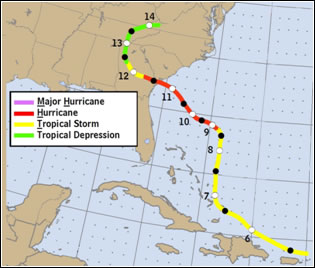
Track of the 1945 hurricane from the National Hurricane Center, National Weather Service archive.
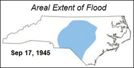
Extent of the flooding, encompassing the Neuse, Cape Fear, and PeeDee river basins. Image is from the United States Geological Survey, Water-Supply Paper 2375, National Water Summary 1988-89, page 428.

Track of Hurricane, National Hurricane Center
Extent of Areal flooding, National Weather Service

Flooding in Fayetteville, NC., Source, Fayetteville Observer, photo from The Bill Belch Collection

Flooding in Fayetteville, NC. Source: Fayetteville Observer; photo from The Bill Belch Collection

Flooding in Fayetteville, NC. Source: Fayetteville Observer; photo form The Bill Belch Collection
Learn More:
Hurricane Floyd impacted many people across the Bahamas and the U.S. East Coast with devastating flooding, storm surge, wind and tornadoes. In total, there were 57 deaths, 56 in the U.S., and 1 in Grand Bahamas Island. Most deaths were attributed to freshwater flooding. Total damage estimates ranged from $3 to $6 billion.
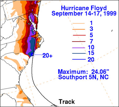
The hardest hit area was eastern North Carolina with 35 deaths, mainly related to inland freshwater flooding. Over 7,000 homes were destroyed and approximately 17,000 homes deemed uninhabitable. Extensive heavy rainfall resulted in flooding of most roads east of I-95. Eastern North Carolina recorded 15 to 20 inches of rain with 24.06 inches measured in Southport, NC. The Tar River in Tarboro crested over 22 feet above flood stage. Winds were strong with sustained winds of 45 to 70 mph inland, 70 to 90 mph along the coast and around 100 mph along the immediate coastline and coastal waters. These impacts resulted in more than 1,500 people rescued from flooded areas, 500,000 customers without electricity, and 10,000 people housed in temporary shelters.
Because of its large size and powerful winds, Hurricane Floyd resulted in a significant storm surge along coastal areas of the state. The maximum surge accompanied high tide aiding in overwash, dune retreat and damage to property along the barrier islands. Storm surge reached 10 to 15 feet above ground level in some locations along the south facing beaches. Floyd also spawned 15 tornadoes across Eastern North Carolina with some structural damage. There was also severe agricultural damage throughout the eastern part of the state. In Duplin county alone, nearly 750,000 turkeys and 100,000 hogs were lost to flooding. This led to health concerns across the area. Total crop loss was around $432 million and total agricultural losses around 634 million dollars for a majority of the area within the North Carolina Disaster Declaration.
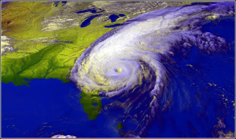
Satellite image of Hurricane Floyd, September 15, 1999, from NOAA GOES satellite; images produced by Hal Pierce, Laboratory for Atmospheres, NASA Goddard Space Flight Center.

Long Beach, NC, September 17, 1999: The devastating 15-foot storm surge that accompanied Hurricane Floyd damaged or destroyed hundreds of houses along this community's ocean front and flattened its frontal sand dunes. Here, 81 year old Mike Semancik, left, and his friend Bob Grazetti, right, use photographs to document the damage. Photo by Dave Gatley, FEMA News Photo
Storm total precipitation in inches
Greenville, NC September 24, 1999: Tar River were communities stranded in flooding waters in Pactolus, just north of Greenville. This family can only reach their flooded home by boat. Photo by Dave Gatley/FEMA News Photo

Edgecombe County, NC, September 19, 1999: Aerial view of severe flooding engulfing populated areas as a result of Hurricane Floyd. Photo by Dave Saville/ FEMA News Photo

North Carolina September 20, 1999: President Clinton talks with North Carolina residents about Hurricane Floyd and the resulting flooding during his trip to the State. White House Photo
Learn More:
|
||||||


