Known as the “Great Flood of 1993,” this flood is considered to be among the most expensive ever in the United States, with total damages of over $15 billion and an overall death toll of 50, of which at least 13 took place in Missouri. This flood evolved from a series of heavy rain events along the Missouri and Mississippi Rivers, culminating with a crest of 49.58 feet and a flow of 1.08 million cubic feet per second on August 1 on the Mississippi River at St. Louis. On this day about 23 miles downstream of the St. Louis gage, the town of Valmeyer, IL, was flooded. The citizens of town decided not to rebuild the town at the same location, opting to rebuild on top of a nearby river bluff. Earlier along the Missouri River, the town of Rhineland, MO, upstream of Hermann, MO, was also destroyed and later rebuilt on higher ground.
The areas of record flooding extended well upstream of both the Missouri and Mississippi Rivers within Missouri, including western Illinois, western Wisconsin, southern Minnesota, southeastern South Dakota, eastern Nebraska, and much of Kansas, Missouri and Iowa. Months of heavy rainfall followed a winter of near to above average snowfall to produce significant spring flooding over much of Missouri. For the first 7 months of 1993, United States Department of Agriculture/Agriculture Stabilization and Conservation Service county offices reported more than 50 inches of rainfall in Osage, Sullivan, and Worth counties, more than twice their normal totals. In June and July, the rainfall intensified as mainly nocturnal thunderstorms affected much of the lower Missouri and middle Mississippi River basins.
Throughout the Midwest, at least 75 towns were completely inundated, an estimated 54,000 people were evacuated, and about 50,000 homes were damaged or destroyed by the flooding. And personal impacts extended well beyond flooded structures. In Iowa, for example, tens of thousands of people were unable to work due to a lack of public water supplies needed for sanitation, fire fighting, and routine operation of businesses.
Transportation was severely affected throughout Missouri. At one point in July, all road bridges between St. Louis and Burlington, IA, were closed due to flooding. On Friday, July 16, only 5 of 28 bridges connecting Missouri with Illinois were open. At one point, all bridges crossing the Missouri River between St. Louis and Kansas City were closed, along with sections of Interstates 29, 35, and 70 across Missouri, all at considerable cost to the trucking industry. Along the Mississippi River, barge traffic was halted for over a month, costing the barge industry between $3-4 million each day. The rail industry suffered losses of over $300 million, with more than $100 million in losses in Missouri alone. Damages to locks and dams and levee systems were staggering. Over a thousand levee systems, including 40 federal levees, were damaged or destroyed.
The agriculture industry also experienced huge losses. More than 600 billion tons of topsoil was removed by the flood and deposited downstream. Over a million acres was flooded, and much of it was farmland. All of this was a complete loss at harvest time, resulting in a total agricultural loss of $1 billion.
 |
| Missouri River at Boonville, Missouri on July 16, 1993 along Highway 5/40 looking north from the north end of the Boonville bridge. |
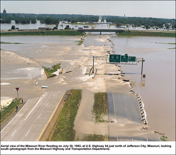 |
| U.S. Highway 54 looking south towards Jefferson City on July 30, 1993. |
 |
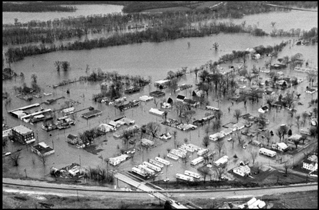
| Lemay, Missouri, along River des Peres with Lemay Ferry Road becoming submerged from right to left. Neighborhood above (east) of Lemay Ferry Road has since been replaced by a park. Photo courtesy U.S. Army Corps of Engineers – St. Louis District. |
 |
| Volunteers sandbagging in downtown Alton, Illinois |
Learn More: