On this page you learn what types of flooding are typical in Minnesota and how do you protect yourself, your family and your home. You will also find out more about significant Minnesota floods. Finally, you'll find links to NWS offices that provide forecast and safety information for Minnesota as well as links to our partners who play a significant role in keeping you safe.
Like most historic spring floods, the 1997 Red River and Minnesota River flood were preceded by an abundance of late season snow. Fargo, ND, which is the oldest climate site in the vicinity located just west of the Minnesota border, received an all-time record 33.6 inches of snow in March and early April. A late March warm up caused the snow to rapidly melt and runoff into the Red River and Minnesota River basins. Finally, widespread rainfall event of 1 to 3 inches on April 5-6 took the already swollen rivers to record levels.
Record flooding occurred at numerous locations along both of these rivers. At East Grand Forks, the Red River crested at 54.35 ft., 8 ft. above major flood stage (46 ft.). At Montevideo, the Minnesota River crested at 23.90 ft., which is 6 ft. above major flood stage (17.5 ft.) and at Granite Falls, it crested at 899.84 ft., 3 ft. above major flood stage (896.5 ft.). The structural damage in Minnesota alone was approximately $300 million dollars, and 58 of the state’s 87 counties were declared Federal disaster areas. Over 23,000 families were affected by the floods, and the total economic impacts were estimated at nearly $2 billion (approximately $2.7 billion in 2013 U.S. Dollars).

The image above shows the 10-day 850mb temperature anomaly from Mar 27 to Apr  5 when compared to the 30 year climatology. The rapid warm up was a driving force behind the 1997 flood.

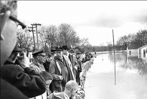
Flooding in downtown East Grand Forks MN. Photo courtesy of FEMA - Dave Saville April 01 1997

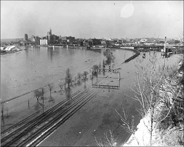
The National Guard transports U.S. Geological Survey personnel across the Red River via the Sorlie Bridge from East Grand Forks, MN to Grand Forks, ND. Photo courtesy of USGS April 18, 1997

Extreme flooding in Rushford, MN in the days a feeter the August, 2007 flash flood in southeastern, MN.
Vehicles nearly submerged by flood waters at a gas station in Rushford, MN on August, 19th 2007.
Learn More:
Inarguably the most impressive rainfall event ever documented in Minnesota occurred in mid-July of 1867 across west central Minnesota along the Sauk and Chippewa Rivers in Pope, Douglas, and Stearns counties. According to historical record, 1867’s warm season rainfall probably approached, or perhaps exceeded the summer of 1993, Â Minnesota’s wettest summer on record in the modern era.
One event in particular dwarfed all others. Â It began on the evening of July 17 with multiple reports of approximately 30 inches of rain by the time the storm ended on the morning of July 19. The event resulted in at least 4 fatalities. According to the Native Americans, “they have never known anything of the kind before.” Countless bridges, booms, and levees were swept away beginning at the upper tributaries of the Sauk and Chippewa Rivers, and downstream along the Mississippi River. The Mississippi river at Minneapolis crested “higher than it was ever known before.” In addition, it is estimated that 25-40 million logs were uncontrollably swept away. The following eye-witness accounts summarized by climate historian Tom St. Martin better portray the severity of this event.
George B. Wright, a pioneer era land surveyor, stated that " …the 18th of July 1867 will long be remembered by those persons who were, at the time in the region comprising the counties of Pope, Douglas and the western part of Stearns...". Wright, who was a member of a survey party operating at the time in an area about 15 miles southwest of Glenwood in Pope County 4, continued by saying that his crew "...experienced rainfall perhaps without parallel in temperate climates..." According to his account, the "remarkable" storm commenced on 17 July with some thunder and lightning and a little wind." He further noted  it seemed to form in the vicinity of the camp and that he "had no clear recollection of its commencement except that the sky clouded up and it began to rain." "The rainfall was moderate at first, but continued to increase during the night. It was not until morning that we became aware of the enormous amount of rain that was falling. The storm lasted about 30 hours and further north and east it is reported to have continued for 36 hours.
Wright's account continued by saying that, although there was no way in which to accurately measure/determine the amount of rainfall received, "people in Sauk Center, Osakis and vicinity, claim with great unanimity that it exceeded 30 and probably reached 36 inches." "I have heard it stated by several of them, reliable persons I believe, that emptybarrels, standing where they could catch no drip or anything but the average rainfall, filled and ran over before the storm ended. One very intelligent farmer at Westport, Pope county, told me that a large kerosene cask, empty, standing on the prairie some rods from any building, filled from two-thirds to three-fourths full.
The river commenced rising at Minneapolis early Thursday morning [18 July] and increased in rapidity and volume as the day advanced. The boom at St. Cloud broke on Wednesday evening and a little before noon on Thursday the river at Minneapolis was filled with logs...On Thursday about four o'clock, the boom belonging to the Minneapolis Boom Company broke...and the logs (about two million feet) went out...Over a million more were in the boom of Dean and Company above the suspension bridge...which did not give way until about noon yesterday. When it broke the logs came down against the bridge in one solid mass...And for a few moments seriously threatened to carry away the bridge...The force and power of the current was perfectly fearful to behold...The bridge withstood the shock, however...."
Learn More:
The largest rainfall event in Twin Cities' history began in the late evening on July 23, 1987. Â Within 6 hours, 10 inches of rain fell at the Twin Cities International Airport, causing massive flooding especially in the southern and western parts of the Twin Cities Metro. The July 23-24 storms occurred along a frontal boundary which, during the preceding week, had separated extremely warm, moist air to the south and east and much cooler, drier air immediately to the north and west. The interaction of these air masses produced intense thunderstorms with extremely heavy rainfall over the southwestern portion of the Twin Cities on 20-21 July 1987, 2 days before this event. Rainfall amounts during this event included 3.83 inches at the Twin Cities airport station, 9.75 inches near Shakopee and 7.83 inches at the neighboring community of Chaska.
The 23-24 July storm formed during the late a afternoon of July 23. At that time, extremely high dewpoints prevailed over most of southern Minnesota and a strong upper level jet stream provided an ample supply of cold air aloft, creating a strong west to east frontal flow. The resulting instability produced the first storm cells just north and west of the Twin Cities. The system moved south but, by mid-evening, became stalled on an east-west axis over the southern part of the Twin Cities area. Successive thunderstorm cells formed along the front throughout the evening and early morning hours, bringing nearly eight hours of heavy rain.
Extreme flash flooding began occurring the evening of July 23 across the Twin Cities metro as many major roads became inundated with water and metro area creeks quickly escaped their banks. Interstate 494 in the south metro was quickly flooded due to the extremely heavy rainfall and caused motorists to rapidly abandon their vehicles in search of higher ground. The water was reportedly up to 8 ft. deep and rose of some cars roof tops. I-494 remained closed for 3 days, a railroad bridge in Bloomington was washed out, and thousands of homes were damaged by the flooding.
Two flood related deaths were reported and property damage was estimated to be in excess of $30 million.

Flooded Interstate 494 at East Bush Lake Road in Bloomington. Photo courtesy of KARE11
Learn More:
|
||||||