On this page you learn what types of flooding are typical in Maine and how do you protect yourself, your family and your home. You will also find out more about significant Maine floods. Finally, you'll find links to NWS offices that provide forecast and safety information for Maine as well as links to our partners who play a significant role in keeping you safe.
The flood of March 1936 occurred in central and southern Maine and affected the Saco, Androscoggin, Carrabassett, Kennebec, Piscataquis, and Penobscot Rivers. This flood event occurred due to 2 separate rain events. The first rain event occurred from March 9-13 when 4 to 8 inches of rain fell in the foothills and mountains of Maine. The next rain event occurred from March 16-19 when another 4 to as much as 10 inches of rain fell. This rain fell on a ripe snowpack that melted quickly. The Kennebec and Androscoggin Rivers still had a thick ice cover and as the ice was lifted and moved downstream, bridges were damaged or destroyed. Large chunks of ice spilled out of the rivers banks along with the flood waters. The ice clogged streets and had to be removed by road crews. Flood damage costs were put at $25 million in 1936 dollars.
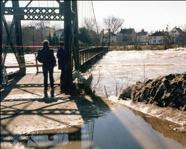
The St. John River flood of April 2008 occurred in northern Aroostook County as the result of up to 5 inches of rain on a ripe snowpack. The snowpack had started to melt away in the middle part of April. This melting resulted in high river levels before the storm arrived. Low pressure moved into northern Maine at the end of April resulting in the heavy rain. Water levels rose steadily; the St. John River at Fort Kent crested at 30.17 feet. The river came within inches of overtopping the dike that protects Fort Kent. More than 600 people were evacuated and 140 homes were flooded. 
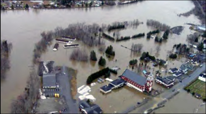
Fort Kent, Maine on May 1, 2008, courtesy Maine Dept. of Public Safety

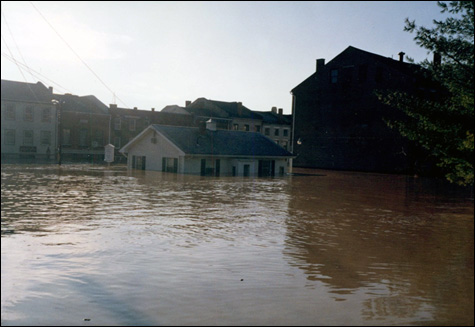
Flooding of International Bridge connecting Fort Kent, Maine to New Brunswick, Canada, on April 30, 2008. Photo by Andrew Cloutier, U.S. Geological Survey
Learn More:
The flood of October 1996 occurred in York and Cumberland counties in southern Maine. Unprecedented rainfall occurred from October 20 to 22. In Camp Ellis, 19.19 inches of rain fell in 48 hours. The Portland International Jetport recorded its greatest 24 hour rainfall ever with 13.32 inches of rain and a 48 hour amount of 14.65 inches. One person died and 15 injuries occurred during the ensuing flood. 2,047 homes and 137 businesses were damaged. Large water mains failed in Portland leaving the city without water for several hours. A boil order was instituted in Portland forcing businesses to close for 5 days. Several wastewater treatment plants were closed due to significant damage and the clam flats from Kittery to Rockland were closed for several days due to the pollution. Many bridges and roads were completely destroyed and the Maine Turnpike was closed for several hours due to flooding. Several school districts closed due to the fact that transportation infrastructure was so damaged it was impossible to go from one location to another. A 10-minute trip would take over an hour. There were 5 dams in southern Maine that were destroyed in the flood with damage to 2 others. Flood damage costs were $10 million in 1996 dollars. This figure is for public damage. Private damage was much higher.
The flood of April 2007 is also known as the Patriot's Day Flood, a Maine April holiday. This flood occurred in southern and central Maine with York County hit hardest. Strong coastal low pressure produced 3 to over 7 inches of rain over a 3-day period resulting in rapid runoff and snowmelt. A maximum of 8.5 inches of rain fell in southern York County on top of a 6 to 12 inch snowpack that had fallen just days before. Two people were killed in York County when they attempted to cross a flooded road on foot and were swept away. Damage costs totaled $45 million. Damage to roads, bridges, waste water treatment plants, public buildings,
Learn More:
|
||||||