National Weather Service United States Department of Commerce
 
Flooding in Indiana

On this page you learn what types of flooding are typical in Kentucky and how do you protect yourself, your family and your home. You will also find out more about significant Kentucky floods. Finally, you'll find links to NWS offices that provide forecast and safety information for Kentucky, as well as links to our partners who play a significant role in keeping you safe.

Significant Kentucky Floods

+The Great Flood of 1937

+The Ohio River Flood of March 1945


Although the Great Flood of 1937 gets most of the attention, the flood that beset the Ohio River Valley eight years later was also extremely damaging. While 1937 is the flood of record at Louisville, 1945 is in second place, with a peak stage at Louisville of 74.4 feet. This stage is about eleven feet below the 1937 stage, and ties with the stage set during the devastating 1884 flood. In response to the 1937 flood which had just occurred 8 years prior the people in Louisville built a sand bag dike on March 4th and 5th to try and contain the river, but the Ohio River was not to be contained. Late on March 5 the river was flowing over the dike and caused in the Louisville area approximately 50,000 citizens to evacuate from their homes and caused total flood damage of around $2,600,000.

Snow melt had very little impact. The deepest snow cover at Louisville between New Year's Day and the flood was only 3 inches on the 29th of January, and that melted away in a few days. The bulk of the heavy rain that caused the flood fell during a three week period leading up to the flood. Rainfall during that time was over 500 percent of normal in southern Indiana, and around 400% of normal along the length of the Ohio River. The rain came in four main waves, on February 20–21, February 25–26, March 1-2, and March 5–6. February 26 still stands as Louisville's 5th wettest February day on record (2.85"), and March 6 is the 10th wettest March day on record (2.66"). The period February 20–March 8, 1945 is the second wettest such period on record at Louisville.

 The Great Ohio River Flood of January 1937
Photos taken in the Butchertown neighborhood in the vicinity of today's I-64/71 split


 The Great Ohio River Flood of January 1937
Onlookers observe the rising Ohio River on 4th Street near Main Street of Louisville.
 

+The Flood of March 1997

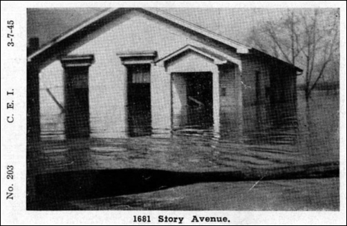
Copious amounts of rain fell on central Kentucky and extreme southern Indiana as the calendar turned from February to March back in 1997. As thunderstorms and large areas of heavy rain repeatedly moved over the same areas, impressive amounts of rainfall were recorded. The deluge resulted in record flooding along smaller streams and some of the worst flooding along the Ohio River since at least 1964, and in some places since the Great Flood of 1937. A few smaller streams set their all-time records.

Water reached the rooftops in Boston (Nelson County). Barge traffic was halted on the Ohio River when the locks flooded. In the Louisville metro area about $200,000,000 in damage was attributed to the flooding, with 50,000 dwellings affected. Interstates 64 and 65 were closed. Ninety-two counties in Kentucky and 14 counties in southern Indiana were declared disaster areas. Tens of thousands of people were evacuated from their homes, with total damage across the region around $400,000,000. Nineteen deaths occurred in Kentucky; 9 were people who attempted to cross flooded roadways.

Navigation on the Ohio River stopped completely due to the locks being flooded. Due to backwater from the Ohio River the flooding was very prolonged. In the Licking River basin, flooding continued until the 7th, Kentucky River basin the 8th, Salt River basin until the 11th, and the Green River basin until the 18th. The middle of the Ohio River stayed above flood stage until the 16th.


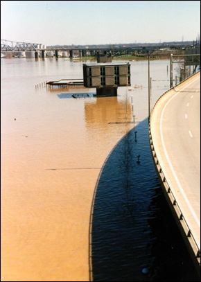
The Louisville waterfront from the Clark Memorial Bridge


 The Great Ohio River Flood of January 1937
View from the Waterfront Development office building

 The Great Ohio River Flood of January 1937
This picture was taken at Pinckard Baptist Church just south of Versailles, Kentucky along KY 169 at Clear Creek. The flooded creek in the picture is normally just a few feet wide and less than a foot deep.

Learn More:

+Great Winter Flood of December 1978

The flood that struck Frankfort in December of that year was the biggest the state’s Capitol had ever seen. On the 10th is when the Kentucky River reached its peak. The river crested at a record 48.47 ft—a full foot over the crest of the Great Flood of 1937. It was on the 10th that more than half of downtown Frankfort was flooded, forcing around 1,000 people to flee from their homes. This almost completely cut off the state Capitol from the rest of the state. However, the Kentucky River was not the only river to be flooded that December. The Salt River in Shepherdsville, South Fork Licking River in Cynthiana, Rolling Fork in Boston, and Green River in Munfordville all had a flood for the record books.

+Torrential Rainfall May 1-2 2010

Strengthening low pressure moving slowly from Texas to Michigan brought copious amounts of Gulf moisture northward that resulted in historic rainfall across the Ohio and Tennessee Valleys. Though the flooding was worse in Tennessee, parts of southern Kentucky were assaulted with 8 to 10 inches of rain. Bowling Green, Marrowbone, Bradfordsville, Richmond, and Albany all set new records for two-day rainfall amounts. Almost all streams and rivers in southern Indiana and central Kentucky experienced some sort of flooding. Areas along the Green River in south central Kentucky attained "major flood" criteria, which had significant impacts on local communities. Dunham Lake Dam on the south fork of the Little Barren River in Metcalfe County was put at a high risk of failing due to flood waters eroding the barrier. The Dunham Lake Dam has since been stabilized. Nearly the entire southern Indiana and central Kentucky warning area was put in a flood emergency Sunday and Sunday night. Stoner Creek at Paris and the Kentucky River at High Bridge attained their 3rd highest crests on record. The Green River at Rochester stayed above flood stage for two weeks following the rain. Damage totaled more than $30,000,000 and there were five fatalities in central Kentucky.
 The Great Ohio River Flood of January 1937
New Haven, KY, Photo Credit: Kevin Harned

 The Great Ohio River Flood of January 1937
Dunham Lake Dam, Little Barren River

 The Great Ohio River Flood of January 1937
Paris Water Treatment Plant, Photo by Kevin Crump

Learn More:

Flood Hazard Information

+Flash Flooding

Flash flooding is a rapid and extreme flow of high water into a normally dry area, or a rapid water level rise in a stream or creek above a predetermined flood level, beginning within six hours of the causative event (i.e., intense rainfall, dam failure, ice jam). More information...

+River Flooding

River flooding occurs when river levels rise and overflow their banks or the edges of their main channel and inundate areas that are normally dry. More information...

+Burn Scars/Debris Flows

Wildfires burn away the vegetation of an area, leaving behind bare ground that tends to repel water. When rain falls, it runs off a burn scar towards a low lying area, sometimes carrying branches, soil and other debris along with it. Without vegetation to hold the soil in place, flooding can produce mud and debris flows. More information...

+Ice/Debris Jams

A back-up of water into surrounding areas can occur when a river or stream is blocked by a build-up of ice or other debris. Debris Jam: A back-up of water into surrounding areas can occur when a river or stream is blocked by a build-up of debris. More information...

+Snowmelt

Flooding due to snowmelt most often occurs in the spring when rapidly warming temperatures quickly melt the snow. The water runs off the already saturated ground into nearby streams and rivers, causing them to rapidly rise and, in some cases, overflow their banks.More information...

+Dry Wash

When heavy rain falls over extremely dry land, the water rushes towards low-lying areas, which may include dried up canyon or river beds. This can quickly turn a dry channel into a raging river.More information...

+Dam Breaks/Levee Failure

A break or failure can occur with little to no warning. Most often they are caused by water overtopping the structure, excessive seepage through the surrounding ground, or a structural failure. More information...
 
Protect Life and Property            NWS Forecast Offices and River Forecast Centers (RFC) Covering Kentucky