National Weather Service United States Department of Commerce
 

On this page you learn what types of flooding are typical in Kansas and how do you protect yourself, your family and your home. You will also find out more about significant Kansas floods. Finally, you will find links to NWS offices that provide forecast and safety information for Kansas, as well as links to our partners who play a significant role in keeping you safe.

Significant Kansas Floods

+Flood of 1951

+Flood of 1903

The historic flood of 1903 affected the Missouri, Kansas, and lower Republican River Basins. The flooding along the Kansas River during May 1903 was the greatest since 1844. A total of 57 people died, 38 of those were in Topeka. The Topeka Daily Capital also reported that 4,000 people were driven from their homes. The Lawrence Daily Journal reported "Desolation everywhere, north side a complete wilderness, country for miles around one vast sheet of water and homes and property have been swept away to destruction."
Kansas River flooding of North Topeka in 1903 (picture courtesy of the USGS) Damage from the flood of 1903 in Lawrence, KS (picture courtesy of the USGS) Railroad bridge in Kansas City, Kansas during the Flood of 1903 (picture courtesy of the USGS)

Learn More:

+Flood of 1993

Widespread and prolonged floods impacted nine states in the Midwest and Kansas was one of the hardest hit. The floods of 1993 took a toll on the Kansas people, who suffered losses of their homes, businesses and farmland. Damage to crop land across Kansas was estimated at more than $400 million while damage to roads and buildings was estimated at more than $47 million. The following basins were affected across northern and eastern Kansas: Republican, Big Blue, Smoky Hill, Kansas, and Marais Des Cygnes.
Figure 62. Areal extent of flooding in the Upper Mississippi River Basin during the Great Midwest Flood of 1993.
 
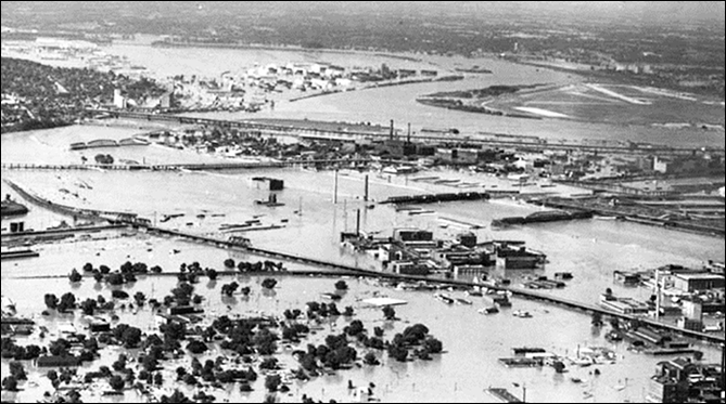
Flooding along the Kansas River at Lecompton (photo taken by the USGS) Water release at Tuttle Creek Dam as the lake had reached capacity (photo taken by the USGS)
Extreme erosion resulted just downstream of the Tuttle Creek spillway due to release of 60,000 cfs during the peak of the flood. (photo taken by the USGS) Kansas River flooding at Manhattan, Kansas (photo taken by the USGS)

Learn More:

+Halloween Flood 1998

A large and intense fall storm slowly rolled over the eastern one-half of Kansas on Halloween 1998 leaving a 2 day deluge of more than 6 inches of rainfall over a 20 county area. Some locations received almost a foot of rain that led to flash flooding as well as historic flooding of rivers draining the region. Nearly one-third of the USGS streamflow-gaging stations in Kansas recorded water levels above flood stage during the first week of November 1998 thus documenting the largest area flooded in Kansas since the 1993 floods. Major flooding occurred in west Wichita along the Cowskin Creek and in parts of Augusta in Butler County. The "Halloween Flood" resulted in $37.8 million in damage, one death and the evacuation of 5,300 people.
Flooding in Augusta, Kansas looking west from a hilltop near 7th and Cliff Drive, (photo courtesy of the Augusta Gazette) 

Learn More:

+Flood of 2007

Floods in Kansas between May and July 2007 caused significant damage in more than 20 counties, resulted in one loss of life, and shattered previous streamflow records at 16 long-term USGS streamgages. In addition, 3,300 structures were damaged due to these floods. The flooding which occurred during May 2007 affected basins from central into parts of eastern Kansas. In July, major flooding affected extreme east and southeast portions of the state. During the July flooding, an oil refinery in Coffeyville, Kansas was inundated by floodwaters from the Verdigris River, causing an oil spill which added further to the devastating impacts of these floods.

Aerial view shows oil spill from Coffeyville Resources refinery in the Verdigris River in Coffeyville, Kansas July 2, 2007. Coffeyville Resources' oil refinery in Kansas was submerged under four to six feet of water due to flooding, a Montgomery County Emergency Management coordinator said Tuesday.
Credit: Reuters/Cindy Price/The Coffeyville Journal/Handout Neosho River flooding at Erie, KS during July 2007 (photo taken by Greg Hunn) Verdigris River flooding Over Highway 160 just east of Independence, KS during July 2007 (photo taken by the USGS)
Aerial view shows oil spill from Coffeyville Resources refinery in the Verdigris River in Coffeyville, Kansas July 2, 2007. Coffeyville Resources' oil refinery in Kansas was submerged under four to six feet of water due to flooding, a Montgomery County Emergency Management coordinator said Tuesday.
Credit: Reuters/Cindy Price/The Coffeyville Journal/Handout
Neosho River flooding at Erie, KS during July 2007 (photo taken by Greg Hunn) Verdigris River flooding Over Highway 160 just east of Independence, KS during July 2007 (photo taken by the USGS)

Learn More:

Flood Hazards Information

+Flash Flooding

Flash flooding is a rapid and extreme flow of high water into a normally dry area, or a rapid water level rise in a stream or creek above a predetermined flood level, beginning within six hours of the causative event (i.e., intense rainfall, dam failure, ice jam). More information...

+River Flooding

River flooding occurs when river levels rise and overflow their banks or the edges of their main channel and inundate areas that are normally dry. More information...

+Burn Scars/Debris Flows

Wildfires burn away the vegetation of an area, leaving behind bare ground that tends to repel water. When rain falls, it runs off a burn scar towards a low lying area, sometimes carrying branches, soil and other debris along with it. Without vegetation to hold the soil in place, flooding can produce mud and debris flows. More information...

+Ice/Debris Jams

A back-up of water into surrounding areas can occur when a river or stream is blocked by a build-up of ice or other debris. Debris Jam: A back-up of water into surrounding areas can occur when a river or stream is blocked by a build-up of debris. More information...

+Snowmelt

Flooding due to snowmelt most often occurs in the spring when rapidly warming temperatures quickly melt the snow. The water runs off the already saturated ground into nearby streams and rivers, causing them to rapidly rise and, in some cases, overflow their banks.More information...

+Dry Wash

When heavy rain falls over extremely dry land, the water rushes towards low-lying areas, which may include dried up canyon or river beds. This can quickly turn a dry channel into a raging river.More information...

+Dam Breaks/Levee Failure

A break or failure can occur with little to no warning. Most often they are caused by water overtopping the structure, excessive seepage through the surrounding ground, or a structural failure. More information...
Protect Life and Property                NWS Forecast Offices and River Forecast Centers (RFC) Covering Kansas