On this page you learn what types of flooding are typical in Iowa and how do you protect yourself, your family and your home. You will also find out more about significant Iowa floods. Finally, you'll find links to NWS offices that provide forecast and safety information for Iowa, as well as links to our partners who play a significant role in keeping you safe.
Many people agree that from a statewide perspective the Great Flood of 1993 and the 2008 Flood were the worst modern-day floods in Iowa history. Although the 2008 affected a smaller geographic area and did not last for as long as did the Great Flood of 1993 in Iowa, the flooding in 2008 was more focused and intense. Its greatest impacts were felt mainly across eastern Iowa especially within the Cedar and Iowa River basins. In the hardest hit areas, the river levels in 2008 exceeded previous record high levels--many of which were set in 1993.
Eighty-five of Iowa’s 99 counties were declared a Federal Disaster Area. Total statewide damage was estimated at $10 billion (nearly $10.9 billion in 2013 inflation-adjusted dollars). More than 40,000 people were affected. One fatality occurred. At the height of the flooding in mid-June approximately 2.5 to 3 million acres of corn and soybeans were underwater. An estimated 2.3 million acres (i.e., around 10%) of Iowa’s cropland lost at least 20 tons of soil per acre. The hardest-hit locations saw stream flows which exceeded the 500-year (0.2% annual chance) event.
Factors that contributed to the Iowa flooding in 2008 began falling into place in 2007. Heavy rainfall in the summer of 2007 and a deep snowpack during the winter of 2007-2008 led to very moist soil conditions and high river levels going into the spring and summer of 2008. Extremely heavy rainfall fell from southwest into northeast Iowa during the first half of June. Amounts of 6 to 8 inches were common some locations reporting 12 to 14 inches over that 2-week period. The result was historic flooding in some locations.
Cedar Rapids and Iowa City were among the hardest-hit cities. In Cedar Rapids the Cedar River crested nearly 20 feet above flood stage, breaking the previous record crest by over 10 feet. Approximately 1,300 blocks (i.e., 10 square miles)--including most of the downtown area--were inundated. Over 5,200 homes were affected. Mays Island--which is home to Cedar Rapids City Hall, the Linn County Courthouse, the County Jail and the Federal Courthouse--was flooded up to the second floor level. In the Iowa City area floodwaters from the Iowa River nearly bisected both that town and Coralville. It also caused significant damage at the University of Iowa. The river crested nearly 10 feet above flood stage and 3 feet above its previous record high crest. Twenty buildings on the University of Iowa campus were flooded including Hancher Auditorium. There were over 6 million sandbags filled in Johnson County. Many other smaller towns in eastern Iowa experienced significant flooding but are too numerous to mention.
Iowa’s transportation network also experienced significant damage. Flooding closed various roads and highways including portions of Interstate 80, Interstate 380 and various other Federal, state and local highways especially in eastern Iowa. At one time the main route from Davenport to Des Moines involved a 115-mile detour.
 |
 |
| Downtown Cedar Rapids, Iowa on June 13, 2008, as the Cedar River crested more than 11 feet above its previous record. Photo by the Iowa Civil Air Patrol. | The Cedar River floods a neighborhood in Cedar Rapids, Iowa, in June 2008. Photo by Scott Olson/Getty Images. |
 |
 |
| Harry Hopkins, WPA administrator, shown with refugees at a concentration camp in Forrest City, Ark., Feb. 1, 1937 during a stopover of President Roosevelt's flood committee on its tour of the stricken area. (AP Photo) | A railroad bridge is partially swept away by Cedar River floodwaters in downtown Waterloo, Iowa, on June 10, 2008 as some people on the opposite river bank look on. Photo by The Waterloo Courier. |
 |
| Significant damage to U.S. Highway 6 becomes apparent after the Cedar River subsides east of Atalissa, Iowa, in June 2008. Photo by the Iowa Department of Transportation. |
For additional photos see also:
Learn More:
Although the Great Flood of 1851 affected a large area of the United States, Iowa was the hardest hit state. Areas of flooding stretched from Nebraska and the eastern Dakotas on the west to the Ohio River valley to the east, and south to the lower Mississippi River basin. The flooding occurred from May to August of 1851 and was the result of record rainfall amounts across the Midwest and Plains.
As much as 74.5 inches of rain fell in Iowa in 1851--a record that has remained unbroken since then. (Compare that amount with the long-term statewide average rainfall of nearly 32.5 inches.) The flood demonstrated its severity by the severity of the flooding and impacts despite the relatively low population in Iowa at the time. Iowa had become a state only 4 1/2 years prior. The flooding in Iowa may have also been exacerbated because the Des Moines River basin--where the worst of the flooding occurred in Iowa--had been settled for less than 10 years. Residents there had never previously experienced a major flood. In addition, towns along the river lacked levees and substantial bridges which could withstand significant flooding. Additional flooding occurred that year along other rivers in the state such as the Cedar, Iowa, Skunk and Maquoketa Rivers.
Although the flood occurred a relatively long time ago, there were many accounts of it in historical documents. In fact it was the second-most written about event in Iowa county histories--only behind the winter snowfall of 1856-1857.
From May to July 1851, much of Des Moines was flooded. According to Mills and Company’s publication “Des Moines City Directory and Business Guide for the Year 1866-1867”:
“The Des Moines and Raccoon Rivers rose to an unprecedented height, inundating the entire country east of the Des Moines River. Crops were utterly destroyed, houses and fences swept away. Farms were covered with drift-wood and other debris, so that the entire work of the season was lost.”
Also, according to the Union Historical Company’s publication “The History of Polk County, Iowa”,
“The damage done to the farms in the river bottoms was immense. Some were stripped utterly of their fences; fields under cultivation were washed into ruts by the violence of the water; all hope of a crop for one season being destroyed, not only by what was carried away, but by the debris which was left by the subsiding of the river. It was almost impossible to estimate the losses. Roads were rendered impassable--bridges swept away--the mails stopped, and traveling by land to any distance utterly vetoed. Houses were carried away, mills damaged, timber floated off, and all manner of mischief done by the flood.”
Some local people blamed the Great Flood of 1851 for a temporary population decrease the Des Moines area after the flood.
Learn MoreAlthough the Rockdale flood affected a very small geographic area, it is the deadliest known flood in Iowa’s history. Rockdale is now a community located entirely within the City of Dubuque--on the town’s southern side. In 1876 Rockdale was a village located between Dubuque and Key West, Iowa. It was also divided by a ravine through which Catfish Creek flowed toward the Mississippi River around 2 miles downstream. Rockdale was located along the main vehicle route going south of Dubuque. It was also home to one of the area’s first flour mills.
The flood occurred on July 4, 1876 when heavy rain caused Catfish Creek to swell and break the dam upstream of town at the Rockdale Mill. The resulting wall of water was around 20 feet deep and hundreds of feet wide as it swept into town. Around 40 people--nearly every person in town--perished in the flood. The few survivors were found in treetops where the floodwaters had swept them. Only 2 buildings were left standing--the Rockdale Mill and one house. The village lost a saloon, hotel, 2 stores, a Post Office, several houses and a blacksmith shop.
One of the most amazing stories of survival involves Charles Thimmesch, a barkeeper. After warning others about the flood he climbed to the roof of the Post Office. He eventually swam naked to higher ground with his money clenched in his teeth.
The village never recovered after the flood. Eventually U.S. Highways 151 and 61 were built and bypassed the area.
 |
| Antique woodcut engraving titled “Iowa-The Disastrous Flood at Rockdale on the Night of July 4th-5th. Scene Near the Dam the Morning After the Storm.” From a Sketch by A. Simplot. This photo was published in Frank Leslie's Illustrated Newspaper on July 29, 1876 |
For additional photos see also:
Learn More:
Deaths: 6
Injuries: Unknown
Impacts: $3.1 billion
Starting on May 8, 1995, severe floods caused extensive damage in southeastern Louisiana and southern Mississippi. The floods shut down the New Orleans metropolitan area, after storm totals of 10 to 20 inches fell over the region.
The May 1995 floods were more extensive and damaging than the Easter Floods of 1979 and the Floods of 1989. The May 1995 flooding was more costly than these two events combined. There has been no comparable recorded flood in New Orleans caused by rain alone.
New Orleans suffered $360 million in damages, and the damage of the surrounding areas put that total above $3 billion, according to National Weather Service. Some 56,000 homes were damaged in 12 Parishes. Thousands of cars were flooded. 14,600 homes and apartments were flooded in Jefferson Parish alone. Rain totals from this event include:
 |
 |
| Floodwaters from the Mississippi River inundate downtown Dubuque, Iowa in April 1965. Photo taken from EncyclopediaDubuque.org (source unknown). | Floodwaters from the Mississippi River affect portions of Clinton, Iowa in April 1965. Photo by the National Weather Service. |
 |
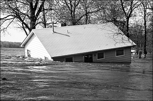 |
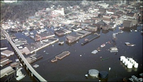
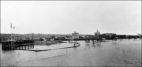
| Floodwaters from the Mississippi River inundate downtown Davenport, Iowa and John'Donnell Stadium in April 1965. Photo by the Quad City Times. | Floodwaters from the Mississippi River sweep away a house near Davenport, Iowa in April 1965. Photo by the Quad City Times. |
For additional photos see also:
Learn More:
|
||||||