.jpg)
On this page you learn what types of flooding are typical in Florida and how do you protect yourself, your family and your home. You will also find out more about significant Florida floods. Finally, you'll find links to NWS offices that provide forecast and safety information for Florida, as well as links to our partners who play a significant role in keeping you safe.
Florida Impacts:
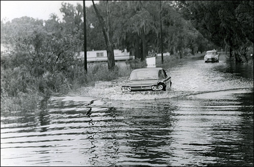
Due to the hurricane approaching the coast at a perpendicular angle and the strong, long duration of onshore winds, tides ran 5-8 feet or more above normal along the northeast Florida coast. Tides were estimated at 12 feet moved across Anastasia Island off St Augustine. Extensive damage was observed along the coast due to the storm surge with numerous coastal roads damaged or destroyed, with over 40 homes lost along the coast. Very heavy rain spread inland as Dora continued to push west over north Florida on Sep 10, while also weakening. On Sep. 11, Dora began to make a near 180 degree turn and headed east-northeast across southern Georgia on the 12th and 13th. This allowed heavy rain to continue across much of north Florida. Storm total rainfall of over 10 inches occurred over an estimated 10,000 square mile area. The heaviest rains fell across Lafayette and Suwannee counties on the 12th. Mayo recorded the greatest storm total with 23.73 inches of rain, while the heavily flooded town of Live Oak recorded 18.62 inches. One death due to drowning was reported in Live Oak.
Dora produced the flood of record on the Santa Fe River at Fort White and was the previous flood of record for the St Mary's River Basin until Tropical Storm Debby in 2012 eclipsed it.Total storm damage in Florida was estimated at $200-230 million ($2.76-3.17 billion dollars 2012 value).
The link below is historical video footage from Hurricane Dora:
http://www.youtube.com/watch?v=KP2qtp0vCww
Hurricane Dora Storm Track
Radar track of Hurricane Dora
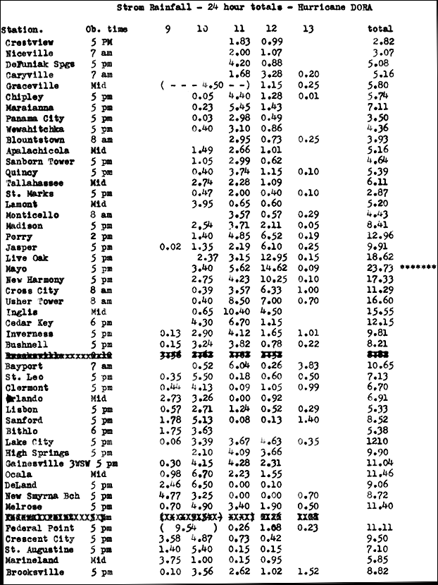
Hurricane Dora Rainfall totals by city
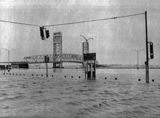
Main St Bridge, Jacksonville FL
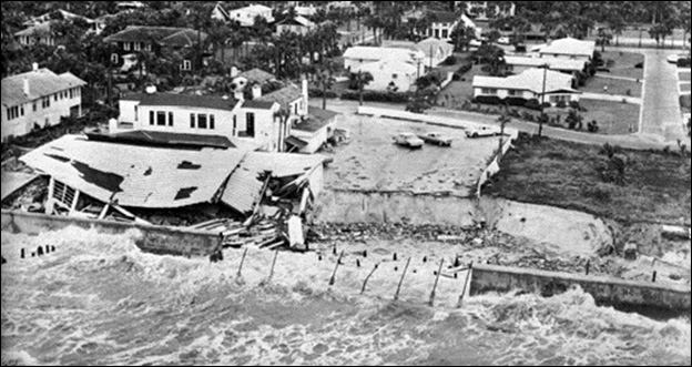
La Chateau, A famous Atlantic Beach restaurant.
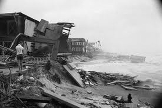
Oceanfront homes destroyed by the storm surge. In all 43 homes were lost along the coast.
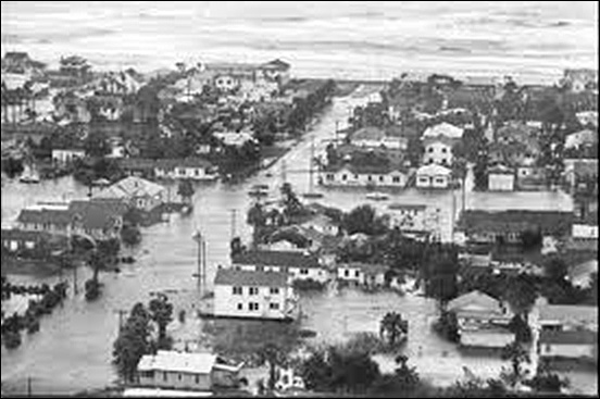
Coastal damage along the Jacksonville Beaches
Coastal flooding in the Jacksonville area
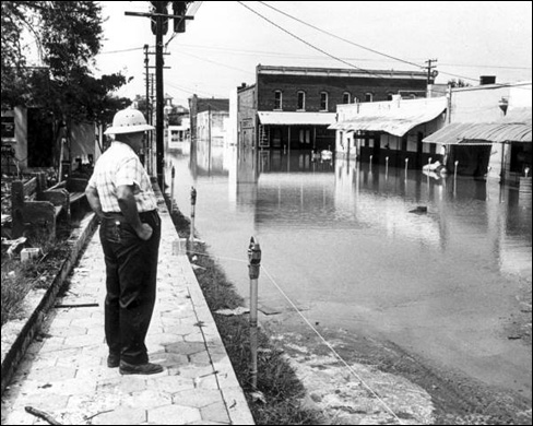
Flooding in Live Oak FL
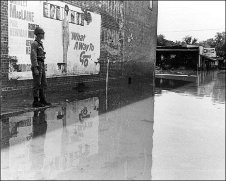
National Guardsman on flood duty, Live Oak, FL
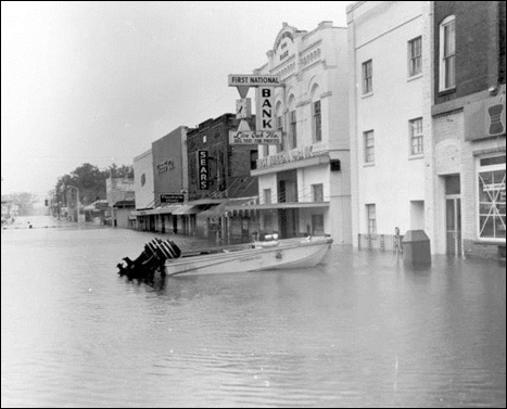
Flooded street in Live Oak, FL
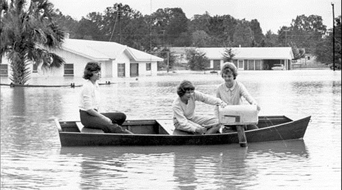
Taking a boat to the mailbox in Live Oak, FL
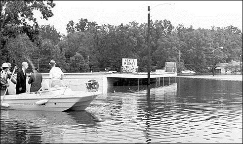
Governor surveying damage in Live Oak, FL
Learn More:
The following report, in part, was submitted from the official in charge of the Weather Bureau office at Miami:
“From Pompano north to Jupiter, especially at Delray, Lake Worth, Palm Beach, West Palm Beach, and Kelsey City, there was serious structural and water damage, the losses greatest at Palm Beach and West Palm Beach. There has been no authentic statement as to the total losses, but they will amount to several million dollars.
In the Lake Okeechobee region, the great loss of life and the damage to property were caused by the overflowing of the lake along the southeast shore, principally at Belle Glade, Pahokee, and South Bay. The small houses in those localities were washed away or inundated, and approximately 2,000 persons were drowned (note this figure has since been revised to over 2,500). In addition to the immediate losses caused by the storm, practically the entire Everglades region south of Lake Okeechobee has been flooded, making it impossible for growers to prepare the land for the usual early winter crops. This condition represents one of the largest items in the list of losses resulting from the storm.”
With the ground saturated and nowhere for the water to flow over the relatively flat lands of south Florida, floodwaters persisted south of the Lake for several weeks, which greatly impeded recovery efforts. Mass graves were used as burial services were overwhelmed. Around 75% of the fatalities were migrant farm workers, making identification of both dead and the missing difficult and the precise death toll unknown. An official casualty estimate by the Red Cross on Oct 28, 1928, put the number of fatalities at 1,836. Further research in 2003 revised the number of deaths to “at least 2,500,” making the Okeechobee hurricane the second deadliest natural disaster in United States history behind the 1900 Galveston Hurricane. Another way to look at the death toll of this horrific hurricane, the population of south Florida was approximately 50,000 people in 1928. That equates to a death toll of at least 5% of the population of south Florida.
There is still tangible evidence of this historical tragedy. In West Palm Beach’s Woodlawn Cemetery, a stone marker stands today in memory of 69 victims of the storm. Also in West Palm Beach, at the corner of Tamarind Avenue and 25th Street, a new State of Florida historical marker stands in sentinel over the place where 674 victims of the storm were buried after being transported from the Belle Glade area. At the Port Mayaca cemetery in Martin County, another stone marker was placed over a mass grave of approximately 1,600 victims. Near the Belle Glade Public Library in downtown Belle Glade, a beautiful memorial stands as a remembrance of the deadly storm and its devastation.
The storm left thousands of people homeless as entire homes were removed from their foundations and smashed to bits in the rapidly moving flood waters. Property damage was estimated at $25 million ($330 million equivalent in 2012 dollars). The hurricane is one of only three to make landfall over south Florida with a central pressure below 940 mbar (27.76 in Hg): 1926 Miami Hurricane and Hurricane Andrew in 1992.
In response to the Okeechobee hurricane, Herbert Hoover personally visited the Lake Okeechobee region, and through Congress directed the U.S. Army Corp of Engineers to create a plan to mitigate flooding and put measures in place to prevent a recurrence of the Okeechobee hurricane. Major flood control projects were implemented with the creation of a series of canals, levees, and control gates to move water through the Lake Okeechobee hydrologic system. The Herbert Hoover Dike was also created, which increased the height of the dike from 4-5 feet to approximately 30 feet. As a result of the hurricane, the Florida State Legislature created the Okeechobee Flood control District. Monitoring and flood control of Lake Okeechobee is currently being accomplished by the South Florida Water Management District which works jointly with USACE to manage the height of the lake year round. The dike has yet to be tested against a category 4 or 5 hurricane, and it remains to be seen whether the dike can withstand such a storm.
Damage and severe flooding post hurricane vicinity Belle Glade.
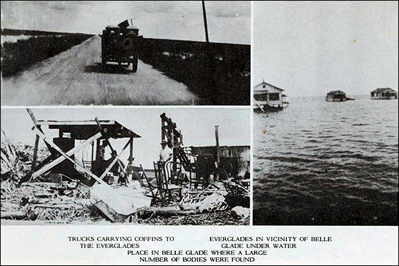
Damage and severe flooding post hurricane vicinity Belle Glade
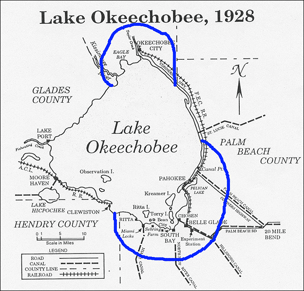
Approximate flood zone. Note: The Palm Beach County label is misplaced. North of Canal Point has been in Martin County since 1925

Track of hurricane Sep 12-20, 1928
Learn More:
Florida Impacts:
Debby was a slow moving tropical storm, and the slow movement and interaction with a non-tropical trough across the Southeast U.S. led to torrential and persistent heavy rainfall for 36-48 hours across north Florida. Widespread heavy rain totaling over 10 inches occurred over west central Florida north of Tampa, over the eastern Florida panhandle, and east across portions of northeast Florida. Two rainfall maximums were observed in excess of 20 inches. One was located over the eastern Florida panhandle and the other between Lake City and the Florida/Georgia border.
Many areas from Apalachicola eastward through Live Oak reported storm total rainfall of over 15 inches. In Panacea, 20.63 inches of rain fell in 24 hours. The peak storm total rainfall occurred in Curtis Mill (Southwestern Wakulla County): 28.78 inches. This report was just outside the area of heaviest rainfall estimated by the Tallahassee radar. Rainfall in the area just south of Tallahassee resulted in widespread flash flooding across much of Wakulla County and led to a record crest on the Sopchoppy River. There was a 29 foot rise in water level on the Sopchoppy River in 30 hours. After the onset of heavy rain, the river reached flood stage in less than 8 hours and major flood stage in 12 hours. At least 400 structures were reported to have been impacted by the flood waters. A record crest on the Suwannee River was also recorded to the northeast of Live Oak at White Springs. Black Creek in Clay County recorded its 2nd highest flood and close to 600 homes along the banks were inundated. Significant flooding also occurred in Live Oak as the Suwannee river was at it’s highest level since hurricane Dora in 1964 which closed a portion of U.S. Highway 90 for nearly two weeks. The St Mary’s River at Macclenny reached a record flood stage with some of the flooding affecting Interstate 10, which was closed for two days when water crossed the roadway. Gainesville, FL recorded its second highest daily rainfall total on record with 6.95 inches of rain on June 24th. In Marion County, State Road 40 was closed due to high water and as many as 50 sinkholes were reported to have formed near roadways.
Across west central Florida, the Suncoast Parkway was closed for a week due to flood waters. Severe flooding was also reported on the Anclote and Pithlachascotee rivers in Pasco county with several communities reporting water “head deep”. Damage occurred to 106 homes along the two rivers. Coastal flooding was also a major problem as significant beach errosion occurred with tides running 3 to 5 feet above normal. Much of Bayshore Blvd in Tampa was flooded for three consecutive days. Storm surge flooding also occurred along U.S. Highway 19 near Hudson.
FEMA’s National Flood Insurance Program (NFIP) reported over $40 million dollars in flood damage across Florida. The total storm damage was estimated at $250 million dollars. 22 counties were declared Federal Disaster Areas.
Not only did Debby produce prolific rains across the Big Bend and northern half of the Florida peninsula, but a tornado outbreak occurred across the central Florida peninsula with a total of 24 tornadoes.
There were four direct deaths attributed to Tropical Storm Debby in the state of Florida. One woman was killed as the result of a tornado. One person drowned in rough surf along the Pinellas county coast. One person drowned when his canoe flipped in Lake County. And one person was found floating in flood waters near Anclote Key and is presumed to have drowned.

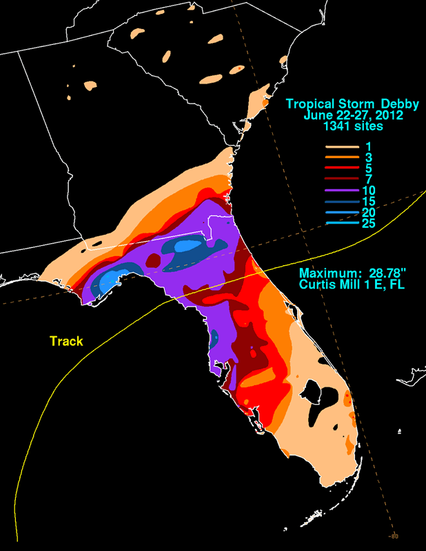
Rainfall totals associated with Tropical Storm Debby, June 22-27, 2012. This map was produced by the NOAA Hydrometeorological Prediction Center

Hydrograph of the Sopchoppy River near Sopchoppy

National Weather Service, Tallahassee FL
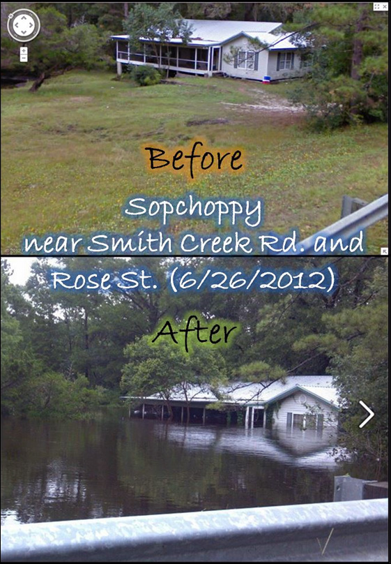
Before and after flooding of home on Sopchoppy River

National Weather Service, Tallahassee FL (Storm Total Precipitation)
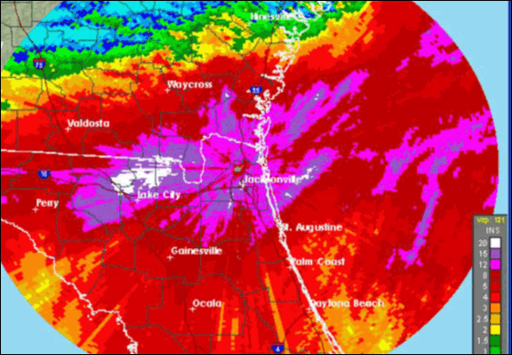
National Weather Service, Jacksonville FL (Storm Total Precipitation)

Flood waters surround a convenience store in Crawfordville, FL, AP Photo/Dave Martin
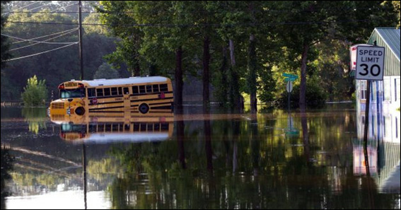
Near downtown Live Oak, FL/ AP Photo/Dave Martin
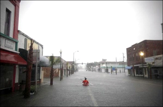
Live Oak, Source: Gainesville Sun
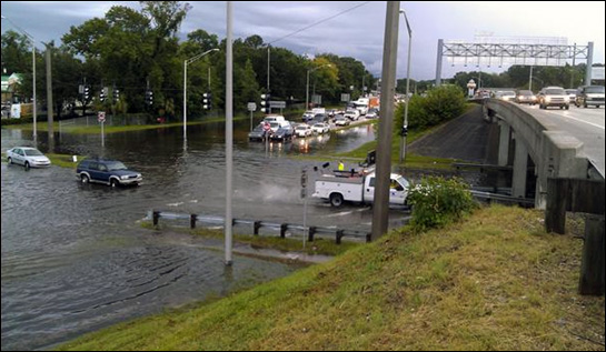
Cassat Ave near I-10 in Jacksonville, FL, Photo by Richard McKinney, First Coast News
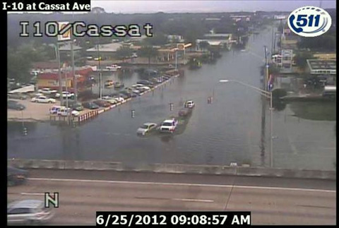
DOT image at I-10 and Cassat Ave in Jacksonville, FL
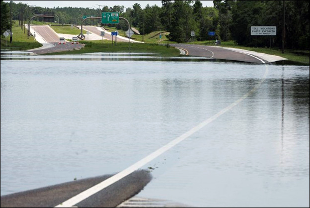
Suncoast Parkway in Hernando County, FL, Photo: Tampa Bay Times/Will Vragovic
Learn More:
Florida Impacts:
The biggest impact from Tropical Storm Fay was the intense rainfall and associated flooding. There were numerous reports of over 20 inches of rain across east central Florida, and rainfall of over 10 inches was common across the remainder of central and north Florida. A good portion of each county of east central Florida measured at least 12 inches of rain in less than 48 hours. Melbourne broke a 50 year old rainfall record when it recorded 11 inches of rain in 24 hours. Numerous roads became impassible across east central Florida, including a few major roads such as State Road 46 in eastern Seminole County, due to the flood waters. Moderate to major flooding occurred on the St Johns River with the forecast point at Geneva recording an all-time record crest. Heavy rain over the Big Bend of Florida and south central Georgia caused the Ochlockonee River above Tallahassee to swell to a record crest at the forecast point near Concord and the second highest crest at the forecast point near Havana. One large subdivision in Leon county required residents to be evacuated by boat as flood waters made roads impassable.
Although widespread flooding occurred across east central Florida, there was one benefit. Lake Okeechobee had been running low due to lingering drought conditions. The significant runoff down the Kissimmee River valley allowed Lake Okeechobee to rise four feet returning the lake to seasonal normal. Not only was Fay a prolific rain maker, but it spawned 18 tornadoes across Florida. One was rated an EF-2 in Wellington, FL which destroyed a weak building and knocked down numerous trees. An EF-1 tornado occurred in Barefoot Bay, which was also suffering the effects of the intense rainfall, and damaged 59 homes with 9 determined to be uninhabitable. The only area of the state that was spared from the heavy rain was west central Florida and the extreme western Florida panhandle.
A significant portion of the damage attributed to Fay was due to flooding. More than 15,000 homes were flooded, the vast majority over east central Florida in the region of the most intense rainfall. Some areas of Brevard and St Lucie counties reported standing water up to five feet deep. Five deaths were reported in Florida as a direct result of Fay. Total damage in Florida was estimated at $390 million dollars. Following Fay, the entire state of Florida was declared a Federal Disaster Area
.
Best track positions for Tropical Storm Fay, August 15-26 2008. Track positions during the inland tropical depression and extratropical stages are based on a blend of analyses from the NOAA Hydrometeorological Prediction Center and the National Hurricane Center.
Rainfall totals for Tropical Storm Fay during its traverse across Florida, Georgia, and Alabama. Rainfall maxima of 27.65 inches occurred 8 nautical miles northwest of Melbourne, FL (graphic courtesy of NOAA/NCEP Hydrometeorological Prediction Center)
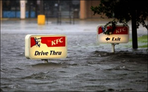
Okeechobee, along State Road 441, Northlake shopping center KFC, Photo: Bill Ingram/The Post
Weeping Willow Way collapse, eastern Leon County

Market Place Square Plaza on U.S. Highway 1 in Jensen Beach, truck under water, AP Photo/Stuart News
Learn More:
|
||||||