On this page you learn what types of flooding are typical in the Washington, D.C., and how do you protect yourself, your family and your home. You will also find out more about significant D.C., floods. Finally, you'll find links to NWS offices that provide forecast and safety information for D.C. as well as links to our partners who play a significant role in keeping you safe.
The same storm that caused the historic dam failure in Johnstown, PA, also affected Washington, D.C. The streets and reservations in the center of the city and all the wharves and streets along the riverfront, were under water. Pennsylvania Avenue was flooded from 2nd to 10th Streets. The Potomac River crested at the Aqueduct Bridge at 19.5 feet on June 2. Additionally, damage occurred on Rock Creek, with the Woodley Lane Bridge washed away. Considerable damage occurred to machinery plants and material at the Navy Yard.
Flooding on Pennsylvania Avenue on June 2, 1889, photo from Library of Congress
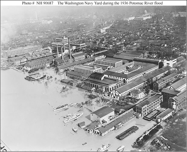
Heavy snow fell throughout the winter of 1935-1936. Warmer temperatures and rainstorms in early March caused rivers to begin to rise. The primary flood-producing rains fell on March 17 and 18 when a storm dumped 1 to 6 inches of rain in 48 hours across much of the area. The Potomac River rose 10 feet above flood stage, submerging much of DC's low-lying areas, including Haines Point and the Navy Yard and Naval Air Station. Debris was a significant problem, with piles more than 10 feet high near the Naval Laboratory remaining after the water receded. This flood caused about $550,000 in damage in DC and about $9.5 million in damage throughout the Potomac Basin. View of the Washington Navy Yard during the 1936 Potomac River flood, U.S. Naval Historical Center Photograph
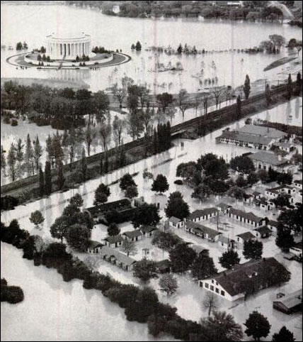
Heavy rain is rare in this region in October, but in 1942 the perfect setup led to extreme rainfall, with 4 to 18 inches falling in a week's time. Widespread totals over 10 inches fell along the Blue Ridge and in spots both west and east of the Blue Ridge, with DC tallying 6 to 7 inches. Although the Potomac River levels upstream finished just shy of those levels experienced in 1936, in the tidal zone of DC, the crest of 17.7 feet was 0.4 foot higher than the previous flood of record. One and a half feet of water covered Maine Avenue at the height of the storm, and hundreds of homes in Georgetown were flooded. Water reached the steps of the Jefferson Memorial.
Flooding in the vicinity of the Jefferson Memorial after the record flood of 1942, photo from NOAA Library
View of the Anacostia River waterfront, looking southeasterly from over the Washington Navy Yard, showing flood conditions. The 11th Street Bridge is at left, with the southeastern portion of the Navy Yard in the lower part of the view and part of the Anacostia Naval Station on the opposite side of the river, U.S. Naval Historical Center Photograph.
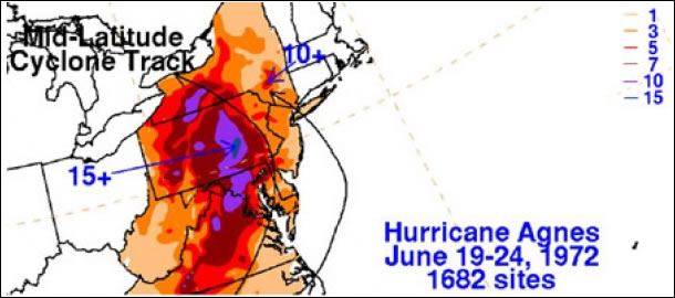
Although Hurricane Agnes made landfall in the Florida Panhandle, the storm re-strengthened as it moved northward toward the Delmarva. Heavy rain had already occurred the week before Agnes, but nothing compared to what Agnes would bring. More than 7 inches of rain fell in DC, and Rock Creek reached its highest recorded stage of 16.20 feet (12,500 cfs), breaking the old record from 1956 by more than three feet. The Potomac at Little Falls crested more than 12 feet above flood stage. About 350 dwellings suffered minor damage in DC, but no fatalities were reported in the District.
Rainfall totals compiled by NOAA Weather Prediction Center for the Hurricane Agnes rainfall event
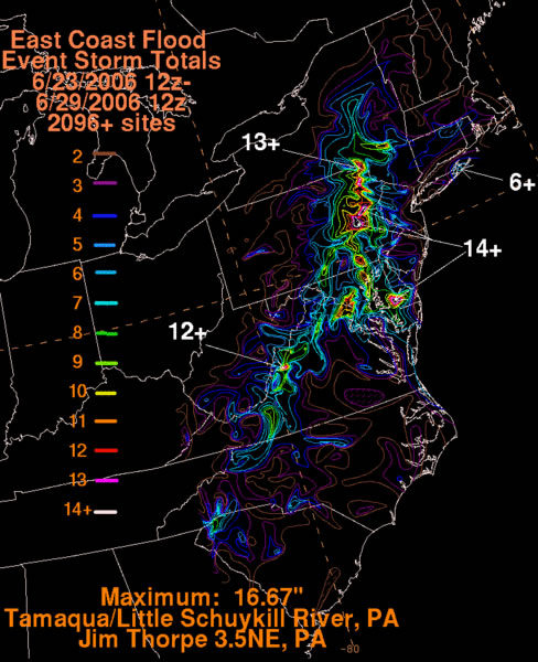
Persistent onshore winds caused copious tropical moisture to move into the region. Significant street and stream flooding was reported in Washington, DC. Several federal buildings, including the National Archives, portions of the Smithsonian Institution, and the IRS building, were flooded, and operations within those buildings impacted for a prolonged period. IRS employees did not begin returning to their headquarters until December. Rock Creek also flooded significantly, with Beach Drive washed out in sections and closed through the summer. The rainfall total at Reagan National Airport of 9.41 inches is the most ever recorded in a 2-day period. No fatalities were reported in the District, but damage totaled $10 million. Water fills the lower portion of the McGowan Theater at the National Archives following the June 26 Federal Triangle Flash Flood. The Theater remained closed until October. Photo by Jeff Reed, National Archives.
Flash flooding is a rapid and extreme flow of high water into a normally dry area, or a rapid water level rise in a stream or creek above a predetermined flood level, beginning within six hours of the causative event (i.e., intense rainfall, dam failure, ice jam). More information...
River flooding occurs when river levels rise and overflow their banks or the edges of their main channel and inundate areas that are normally dry. More information...
At any time of year, a storm from over the ocean can bring heavy precipitation to the U.S. coasts. Whether such a storm is tropical or not, prolonged periods of heavy precipitation can cause flooding in coastal areas, as well as further inland as the storm moves on shore. More information...
A back-up of water into surrounding areas can occur when a river or stream is blocked by a build-up of ice or other debris. Debris Jam: A back-up of water into surrounding areas can occur when a river or stream is blocked by a build-up of debris. More information...
Flooding due to snowmelt most often occurs in the spring when rapidly warming temperatures quickly melt the snow. The water runs off the already saturated ground into nearby streams and rivers, causing them to rapidly rise and, in some cases, overflow their banks.More information...
A break or failure can occur with little to no warning. Most often they are caused by water overtopping the structure, excessive seepage through the surrounding ground, or a structural failure. More information...
Protect Life and Property NWS Forecast Offices and River Forecast Center (RFC) Covering D.C.