On this page you learn what types of flooding are typical in Colorado and how do you protect yourself, your family and your home. You will also find out more about significant Colorado floods. Finally, you'll find links to NWS offices that provide forecast and safety information for Colorado, as well as links to our partners who play a significant role in keeping you safe.
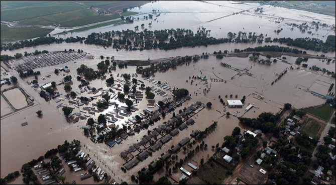
On the evening of June 16, 1965, 14 inches of rain near Larkspur, CO, sent a violent wall of water, 20 feet high in some places, down Plum Creek and into the South Platte River, wiping out bridges, roads and homes as it tore through Denver. The South Platte, itself swollen by rain, crested at 25 feet above normal.
A floating logjam of debris, including lumber, trees, old cars and refrigerators, became a battering ram as it moved downstream, destroying roads and 26 bridges in its path. A massive rescue operation by owners, trainers and jockeys saved about 140 horses at the Centennial Racetrack. Power plants along the river were shut down, and emergency circuits became waterlogged and shorted out. As the flood continued north, other tributaries added their water: Sand Creek, Clear Creek, the Bijou, Little Beaver and the Cache La Poudre River. The course of the South Platte River to the Colorado-Nebraska border was a mud-encased, wreckage-strewn landscape of desolation. The communities of Sterling, Fort Morgan and Brush became isolated as the waters spread out over a quarter-million acres of farmland. Denver's water supply, which consisted mainly of a series of wells along the river, was nearly destroyed.
The flood crest did not pass the most-downstream gaging station on the South Platte River in Colorado until June 20, 1965. Damage estimates came to about $540 million. The storm claimed 28 lives. Peak discharges at several gauging stations had recurrence intervals that exceeded 100 years. The peak discharge on the South Platte River at Denver was 40,300 feet cfs. In the wake of the flood, plans were quickly finalized and construction began on the Chatfield Dam, completed in 1972.
 |
| Photo courtesy Denver Post |
Learn More:
What started out as just another day in June rapidly turned into one that would never be forgotten in the city of Pueblo. A cloudburst enveloped the town the afternoon of June 3, 1921. During a typical cloudburst, over half an inch of rain may fall in a matter of minutes, and that is exactly what happened in Pueblo, creating devastating consequences for the heart of the town where the Arkansas River and Fountain Creek meet. At about the same time the rains were drenching the downtown area, there was another downpour about 30 miles north over Fountain Creek. Records indicated a total of 6 inches or more fell from June 3-5.
As torrential rains fell, the Arkansas River and Fountain Creek quickly began to swell, reaching over 15 feet in some areas. Within 2 hours, the entire wholesale district and a greater part of the business district of Pueblo were flooded with water 10 feet deep. The entire Arkansas Valley, from 30 miles west of Pueblo to the Colorado-Kansas state line, was severely impacted. Hundreds of people died, with some death toll estimates as high as 1,500. The flood destroyed almost all of the downtown Pueblo area and decimated the city.
Once the floodwaters receded, the immense damage became all the more visible. The flood, which covered over 300 square miles, carried away over 600 homes and caused upwards of $25 million in damage at the time. By today's standards, that number would likely be $300 million or more. Railroad passenger coaches and freight cars were swept away in every direction or smashed into kindling. A fire even broke out in a lumberyard and burning lumber was carried throughout the city’s streets by the flood. The floodwaters also carried away entire buildings and businesses. Many of the dead were likely carried far down river and never recovered.
 |
| Debris on the 200 block of North Main Street in Pueblo, CO, after the June 3, 1921 flood. Courtesy Photos/Pueblo City-County Library District |
Learn More:
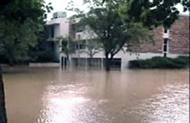
The Fort Collins flood resulted from an intense storm cell that developed during the early evening of July 28th and remained stationary for approximately 4 hours. The storm dropped 8 to 10 inches of rain in 5 hours on ground already saturated from previous rains in the western part of the city. The resulting runoff overwhelmed the natural and man-made drainage systems that normally collect storm water from this area and flow through Fort Collins to the Cache La Poudre River. The maximum flow through the downstream section of Spring Creek has been estimated at more than 5,000 cfs, more than twice the peak flow that had been anticipated in the design of the floodway. The combined flow of the tributaries into the lake from Spring Creek and Canal Importation Basins was estimated to peak at 8,250 cfs, more than double the projected flow for a 500-year flood. There was over 100 million dollars in damage at Colorado State University alone. The resulting flooding of Spring Creek caused a moving freight train to derail The most serious situation developed as the intense rainfall was ending and occurred downstream of the heaviest precipitation. A deluge of water was released from behind a railroad embankment inundating two mobile home parks and several homes and businesses along South College Avenue. Five persons died when the trailer park was inundated. At its peak the water level was approximately 2 feet above the railroad tracks and the instantaneous surge flow over and under the embankment may have been as high as 8,000 cfs. This peak flow lasted for 20 to 30 minutes before the water level began to slowly recede.
The extreme variation in rainfall across the city of Fort Collins was the impetus behind the vision and establishment of the CoCoRaHS program in Colorado. CoCoRaHS is now a nationwide program with over 19,000 voluntary observers providing rain fall information daily.
 |
 |
 |
| Graphic courtesy NOAA/ESRL |
Learn More:
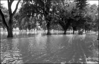
Saturday, July 31, Colorado was celebrating 100 years of statehood and, by late afternoon, an estimated 2,500 to 3,500 people were driving into or already staying in one of Colorado's most scenic and natural river valleys, the Big Thompson Canyon. A thunderstorm lifted along the Front Range of the Rockies and began to dump heavy rain on the region. Light winds in the upper atmosphere allowed the storm to remain virtually stationary over the Big Thompson Valley. Heavy rain fell over a 70-square-mile area in the central portion of the Big Thompson watershed from 6:30-11:00 pm. The most intense rainfall, between 12 and 14 inches, fell on slopes in the western end of the canyon. Water in the river quickly rose over banks and raged through the canyon corridors.
The flood washed out all stream and rain gages so accurate measurements were not possible. The flood crest on the Big Thompson River moved through the 7.6 miles between Drake and the canyon mouth in about 30 minutes, at an average speed of about 15 miles per hour. At times the torrent of water was 19 feet high. Flash flooding destroyed recreation and commercial buildings built along the rivers banks. U.S. Highway 34, the only road that exits the canyon, was washed out. The floodwater was so powerful that 10-foot-wide boulders were lifted and carried down-river. Cars were easily swept away. Many of the lives lost were campers who had set their camps near the river. The flood of July 31-August 1, 1976, on the Big Thompson and Cache la Poudre Rivers, resulted in 143 deaths, 150 injuries, and total damage of about $39 million.
 |
 |
| Dave Buresh/Denver Post File | Ernie Leyba/Denver Post File |
Learn More:
|
||||||


