Please join us in promoting severe weather safety during this year's "Severe Weather Awareness Week". The National Weather Service asks emergency management, public safety officials, local media and Weather-Ready Nation Ambassadors to help join forces in improving the nation's readiness, responsiveness, and overall resilience against severe weather during the upcoming season.
| NWS Blacksburg Virtual Skywarn Spotter Training on March 10th at 630 PM. Click here to register. | March 7th, 7 pm - LIVE question and answer with NWS experts
|
Each day this week, a different topic will be covered. Click on the tabs below for more severe weather preparedness information.
MONDAY
 |
 |
WHAT's A WATCH?? |
WAYS TO GET WARNINGS
|
HOW DO I PREPARE FOR SEVERE WEATHER OR EMERGENCIES? |
WHAT ARE WIRELESS EMERGENCY ALERTS (WEA)?
|
TUESDAY
 |
 |
 |
 |
 |
 |
| Tornado Basics | How Do Tornadoes Form? | Tornado Simulator | Tornado Rating | Tornado Safety
|
WEDNESDAY
 |
 |
 |
 |
| Thunderstorm basics | Hail basics. What is it and how does it form | Damaging Winds from Thunderstorms | Thunderstorm Safety and Preparedness
|
THURSDAY
 |
 |
 |
 |
 |
| Flooding Basics | Flooding in Virginia - Historic flood events | Types of flooding | Virginia Flood Awareness Week | Flood Safety Tips
|
FRIDAY
 |
 |
 |
 |
 |
| What is Lightning? | Types of Lightning | A Lightning Survivor Story | Lightning Myths | Lightning Safety
|
TORNADO DRILL PREPAREDNESS INFORMATION
Statewide Tornado Drill Information
Virginia’s annual statewide tornado drill for 2022 will take place on Tuesday, March 8, at 9:45 AM EST.Every school, business, work place, and family across the state is strongly encouraged to participate in the statewide tornado drill. |
Here are some key points to remember about the drill:
|
Frequently Asked Questions
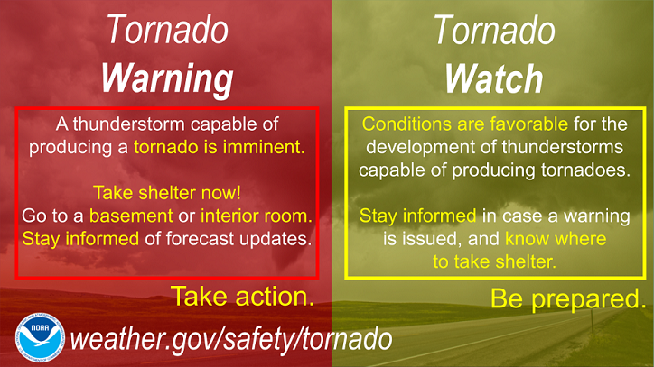
1. What is the difference between weather Watches and Warnings?
A WATCH (Severe Thunderstorm or Tornado) is issued when severe thunderstorms and/or tornadoes are possible in and near the watch area. It does not mean that they will occur. It only means they are possible.
Severe thunderstorms are defined as follows:
1) Winds of 58 mph or higher
AND/OR
2) Hail 1 inch in diameter or larger.
A WARNING is issued by your local NWS office when a Severe Thunderstorm or Tornado is imminent or occurring. Seek safe shelter and observe safety protocols.
2. Can a Severe Thunderstorm Warning be issued without a Watch in effect?
Yes it can. While the majority of the time a watch is in place prior to a warning being issued, there are times a warning is issued for a storm with no watch having been issued. This is usually in a situation where a lone storm or maybe a couple storms briefly get strong enough to produce damaging winds or hail in a localized area, but the overall conditions do not support widespread severe weather.
3. What is meant by the Marginal, Slight, Enhanced, Moderate, and High risk categories in the Convective Outlook?
Marginal, Slight, Enhanced, Moderate, and High risks represent progressively larger threats for organized severe storm episodes. These risks, along with their numerical, abbreviated labels, and colors (1-MRGL-dark green, 2-SLGT-yellow, 3-ENH-orange, 4-MDT-red, 5-HIGH-magenta), are based directly on Severe Thunderstorm Risks issued by the Storm Prediction Center.
4. What does it mean to be “Weather Ready Nation (WRN)”?
NOAA’s Weather–Ready Nation (WRN) is about readying your community for extreme weather, water, and climate events. The devastating impacts of extreme events like record breaking snowfall, violent tornadoes, destructive hurricanes, widespread flooding, and devastating drought can be reduced by taking advanced action, which is why the Weather–Ready Nation initiative is so important. You can get more information at the national WRN site, linked here: https://www.weather.gov/wrn.
5. How Do I Prepare for a Tornado? What Steps Do I Take When a Warning is Issued?
YouTube - Tornado Safety (ASL/CC)
YouTube - Preparedness Videos
YouTube - Get Weather Ready: Before A Tornado
YouTube - Get Weather Ready: During A Tornado
YouTube - Get Weather Ready: After A Tornado
Find more information at the following address: https://www.weather.gov/safety/tornado-prepare.
6. How many tornadoes occur per year in our area?


Also, The Storm Prediction Center has prepared a series of charts based upon climatology, received severe weather reports from NWS Storm Data, and annual summaries. Their page is located here: https://www.spc.noaa.gov/wcm/#torclim
7. I have additional questions on tornadoes not answered here. Where can I look for more information?
Additional FAQ on tornadoes are answered at the Storm Prediction Center Tornado FAQ page: https://www.spc.noaa.gov/faq/tornado/
8. What are Wireless Emergency Alerts (WEA)?
Wireless Emergency Alerts (WEA) are emergency messages, usually less than 90 characters, that are sent directly to your phone by authorized government alerting authorities through your mobile carrier. Government partners include local and state public safety agencies, FEMA, the FCC, the Department of Homeland Security, and the National Weather Service. Get more information at https://www.ready.gov/alerts.
9. What is the SKYWARN Program?
The SKYWARN program is a group of volunteers that are trained by the National Weather Service to properly observe and report severe weather conditions to the National Weather Service. These observations serve as critical ground truth and are one of the key ingredients to our severe weather warning process. You can find and register for future training classes, see recorded training modules, and get more information at https://www.weather.gov/akq/SKYWARN.
Awareness Week Activities
Find us on social media:
You can also contact:
Phil Hysell Phil.Hysell@noaa.gov for additional information about Severe Weather Preparedness.