National Weather Service United States Department of Commerce

NWS Blacksburg Watch, Warning and Advisory Criteria


Severe Weather Events...

Severe Thunderstorm Warning
 

Base

  • Thunderstorm wind gusts of 58 mph,
  • AND/OR hail measuring 1" in diameter.
     

CONSIDERABLE

  • Thunderstorm wind gusts of 70 mph,
  • AND/OR hail measuring 1.75" in diameter (golf ball-sized).

DESTRUCTIVE

  • Thunderstorm wind gusts of 80 mph or greater,
  • AND/OR hail measuring 2.75" in diameter (baseball-sized) or larger.


Tornado Warning

Issued when

  • Tornado observed or indicated by radar.

NO TAG

  • Tornado damage possible, duration short-lived

CONSIDERABLE

  • When there is credible evidence that a tornado, capable of producing considerable damage, is imminent or ongoing.

CATASTROPHIC

  • When a severe threat to human life and catastrophic damage from a tornado is occurring, and will only be used when reliable sources confirm a violent tornado.


Special Weather Statement

  • Thunderstorm wind gusts of 40 to 57 mph,
  • Hail less than 1" in diameter,
  • Frequent to continuous lightning.

See NWSI 10-511 WFO Severe Weather Products Specification for additional information.


Flood Events...

Flash Flood Warning

  • Life or property-threatening, short-term flooding is imminent or occurring.  This can include flooding due to heavy rainfall or due to a dam or levee break.


base NO TAG

  • When flash flood impact damage is possible.

CONSIDERABLE

  • Indications that flash flooding is capable of unusual severity or impact is imminent or ongoing and urgent action is needed to protect lives and property.

CATASTROPHIC

  • When a flash flood threat to life and catastrophic damage is occurring or imminent, and floodwaters have risen or will rise to levels rarely if ever seen.


Flood Warning

  • Flooding due to potentially damaging river level rises,
  • OR overland flooding that is expected to persist for many hours.

Flood Advisory

  • Nuisance flooding including river/stream flooding and/or ponding of water in a geographic area that warrants notification of the public but less urgent than a warning.

Special Weather Statement

  • Heavy rainfall that can cause hazardous travel conditions but is not expected to cause flooding.

See NWSI 10-922 WFO Hydrologic Products Specification for additional information.


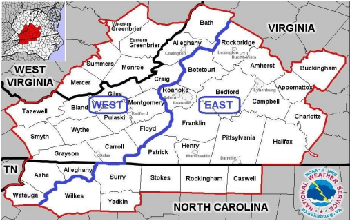
Winter Weather Events...(see regional criteria map below)

Blizzard Warning

  • Sustained wind or frequent gusts of 35 mph or higher,
  • AND visibility less than 1/4 mile in snow and/or blowing snow for 3 hours or longer.

Ice Storm Warning

  • Damaging ice accumulations of 1/4" or more.

Winter Storm Warning

  • Snowfall of 4" foothills/piedmont and 5" mountains.
  • Sleet 2" area wide
  • OR combination of snow/sleet that would accumulate to warning levels,
  • OR if severe impact based on time of year/day occurs (ex, 2 inches of snow in 2 hours during rush hour).

Winter Weather Advisory

  • Snowfall of 2" foothills/piedmont to 3" mountains in a 12 hour period,
  • AND/OR sleet that is enough to cause significant inconvenience or requires extra caution.
  • AND/OR freezing rain less than a quarter (1/4") inch.
  • Black Ice for North Carolina only (This is only done on the first night after winter weather precipitation has ended)
 

Wind Chill Warning

  • Wind chills of 20 below or colder (mountains) or 15 below or colder (foothills/piedmont) are expected , and a minimum wind speed of 5 mph or more.

Wind Chill Advisory

  • Wind chills of 5 below to 19 below (mountains) or zero to 14 below (foothills/piedmont), and a wind speed of 5 mph or more.

Special Weather Statement

  • Black ice, West Virginia and Virginia,
  • OR short-duration snow/sleet less than advisory levels.

See NWSI 10-513 WFO Winter Weather Products Specifications for additional information.


Non-Precipitation Events...

High Wind Warning

  • Sustained non-thunderstorm wind speeds of at least 40 mph for an hour or more,
  • OR non-thunderstorm wind gusts of at least 58 mph regardless of duration.

Wind Advisory

  • Sustained non-thunderstorm wind speeds between 31 and 39 mph for at least one hour,
  • OR non-thunderstorm wind gusts of 46 to 57 mph for any duration.
 

Freeze Warning

  • Issued in conjunction with forecast low temperatures of less than or equal to 32 degrees across half or more of the county. Sufficient to end the growing season in fall, or delay it in the spring. Generally not issued between mid November and mid April.

Frost Advisory

  • Widespread frost during the growing season. Usually with low temperatures forecast from 33 to 36 degrees, with light/calm winds.

Excessive Heat Warning (see graphics below)

  • Issued when the heat index is expected to reach 105 or greater in the mountains and 110 or greater in the Piedmont.

Heat Advisory

  • Issued for heat index of 100 to 104 in the mountains and 105 to 109 for the Piedmont.

Dense Fog Advisory

  • Widespread visibility 1/4 mile or less due to dense fog.
 

Special Weather Statement

  • Heat indices or wind chill values near "advisory" level for an hour or two,
  • OR local areas of dense fog, dense smoke or other hazards that are below advisory criteria.

See NWSI 10-515 WFO Non-Precipitation Weather Products Specification for additional information.


Fire Weather Events...

Red Flag Warning for:

North Carolina: two or more of the following weather criteria (1 to 4) must be occurring or expected, in addition to high (or greater) fire danger

  • Sustained 20-foot wind speeds of 20 mph or greater, or gusts to 30 mph,
  • Minimum relative humidity of 25% or less,
  • Dry Lightning,
  • A significant wind shift during times of active fire suppression
  • High, Very High, or Extreme Fire Danger, as assessed by the natural resource agencies.
 

Virginia: the following weather criteria must be met, in addition to low fuel moisture:

  • Ten-hour fuel moistures are observed or expected to be 7 percent or less.
  • AND Minimum relative humidity of below 30 percent at any time over the forecast area,
  • AND Sustained wind of 20 mph or more.
  • For counties east of the Blue Ridge the air temperature must also be above 40 degrees F.
 

West Virginia: the following weather criteria must be met, in addition to low fuel moisture:

  • Ten-hour fuel moistures are observed or expected to be 8 percent or less.
  • AND Minimum relative humidity of below 25 percent at any time over the forecast area,
  • AND Sustained wind of 15 mph or more.
 

See NWSI 10-401 Fire Weather Services Product Specification for additional information.


Winter Weather Regional Criteria


Ice Storm Criteria


Wind Chill Warning Criteria map

Wind Chill Advisory Criteria


Heat Threshold Regional Criteria


Heat Index criteria map