Overview
|
A potent low pressure system crossed the area Friday, May 6th. A northward-shifting warm front and late-day development secondary surface low yielded an environment conducive for supercells, and bowing segments, with damaging winds a couple of tornadoes in addition to isolated large hail. Two tornadoes impacted our area, along with damaging winds and hail up to the size of tennis balls. This was the the greatest number of warnings (36) for one day our office has issued since June 21, 2011 |
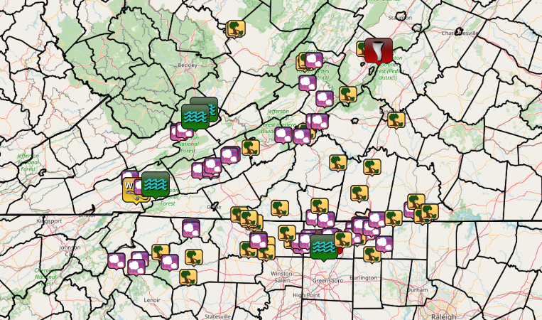 Plot of Storm Reports from May 6th. |
Tornadoes:
|
Tornado - Wentworth-Reidsville
Track Map 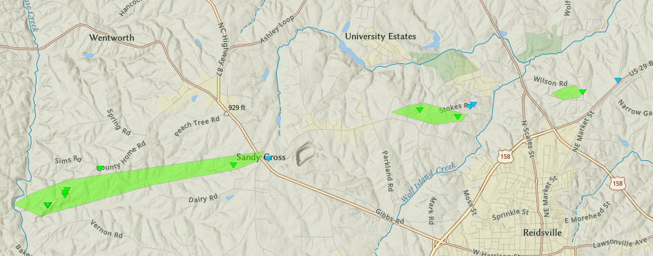 
|
||||||||||||||||
|
Tornado - Fairfield, VA
Track Map 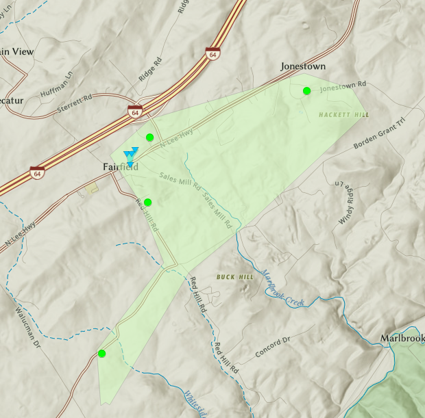
|
||||||||||||||||
The Enhanced Fujita (EF) Scale classifies tornadoes into the following categories:
| EF0 Weak 65-85 mph |
EF1 Moderate 86-110 mph |
EF2 Significant 111-135 mph |
EF3 Severe 136-165 mph |
EF4 Extreme 166-200 mph |
EF5 Catastrophic 200+ mph |
 |
|||||
Photos
 |
 |
 |
 |
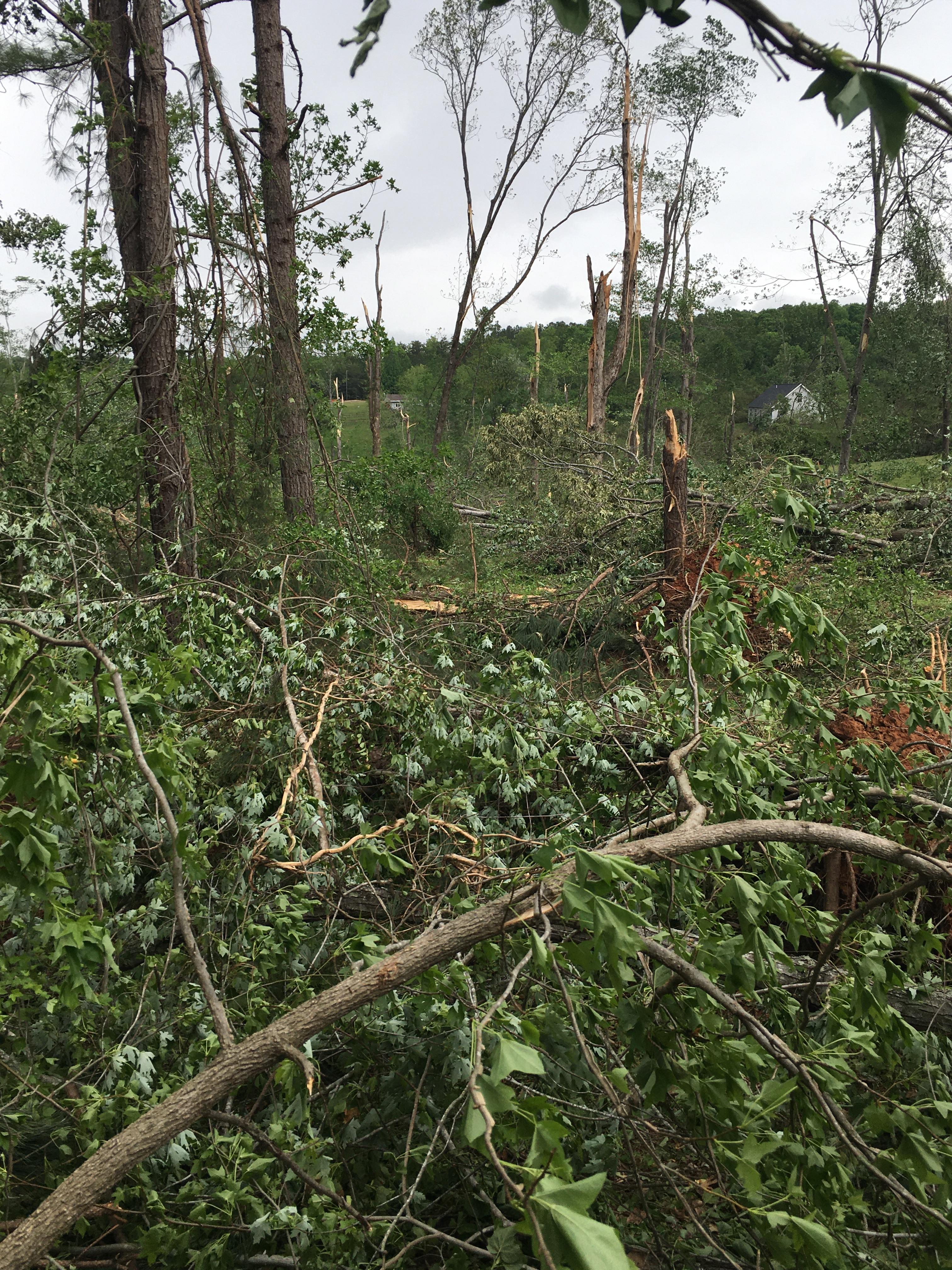
| Trees Snapped Along Sunset View Road, south of Wentworth, NC (NWS Survey) |
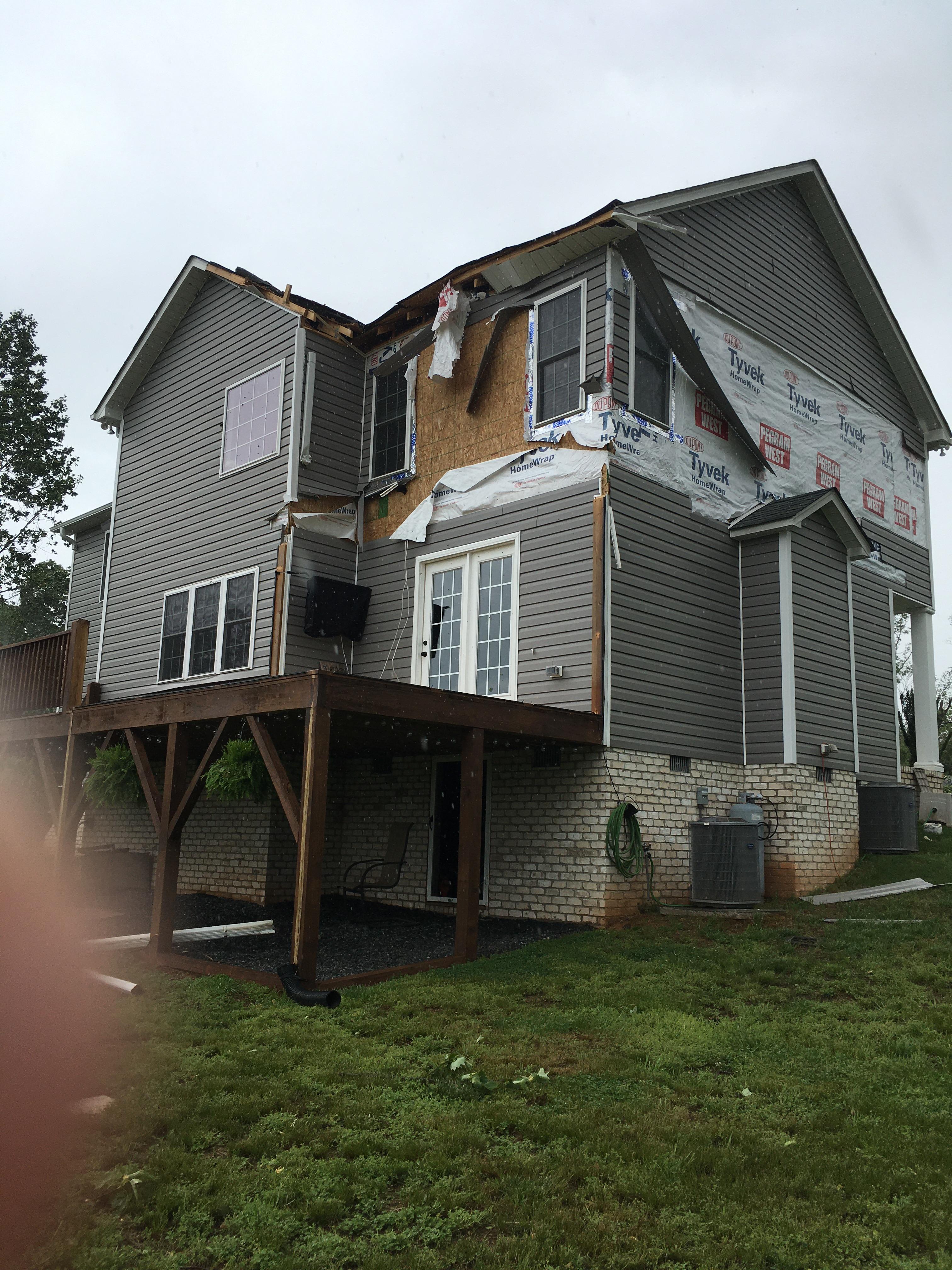
Partial roof and siding damage to home off of Sunset View Road, Wentworth, NC (NWS Survey) |
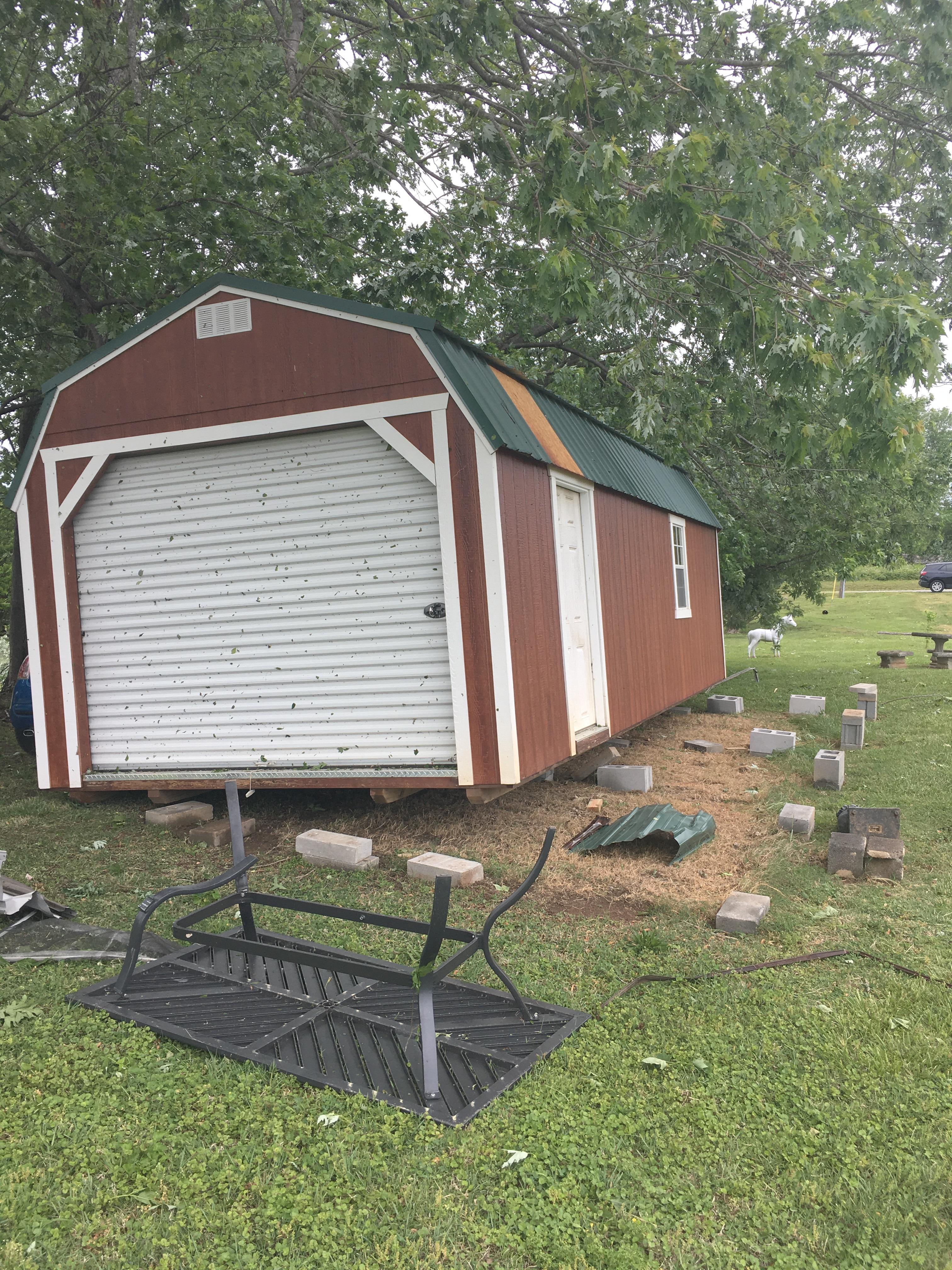
Barn was pushed off its foundation, U.S. 29 northeast of Reidsville (NWS Survey) |
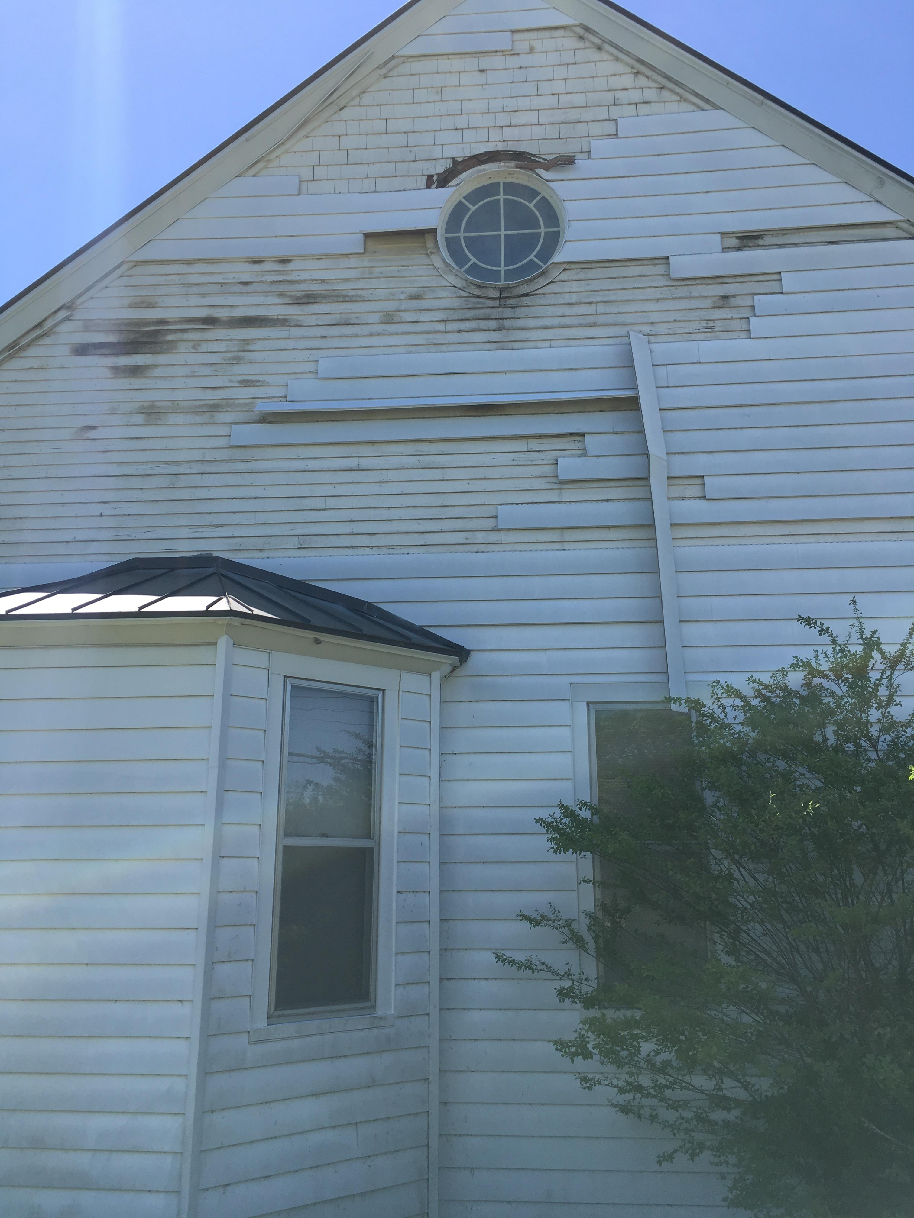
Roofing and siding damage, Fairfield, VA (NWS Survey) |
Storm Reports
..TIME... ...EVENT... ...CITY LOCATION... ...LAT.LON...
..DATE... ....MAG.... ..COUNTY LOCATION..ST.. ...SOURCE....
..REMARKS..
0115 PM TSTM WND DMG QUINWOOD 38.06N 80.70W
05/06/2022 GREENBRIER WV 911 CALL CENTER
SEVERAL TREES AND POWER LINES DOWN IN THE
QUINWOOD AREA.
0500 PM TSTM WND DMG 1 SE JERICHO 36.27N 79.35W
05/06/2022 CASWELL NC 911 CALL CENTER
TREE DOWN ALONG HIGHWAY 62S IN ANDERSON, NC.
0513 PM HAIL 2 ESE TOPNOT 36.36N 79.23W
05/06/2022 E1.50 INCH CASWELL NC PUBLIC
0535 PM HAIL 1 NNW BLUEFIELD 37.25N 81.27W
05/06/2022 E0.88 INCH TAZEWELL VA PUBLIC
DIME TO NICKEL HAIL.
0537 PM TSTM WND DMG CHILHOWIE 36.80N 81.68W
05/06/2022 SMYTH VA EMERGENCY MNGR
ROOF BLOWN OFF ONE STRUCTURE ALONG MAIN
STREET IN CHILHOWIE DUE TO THUNDERSTORM
WINDS.
0539 PM TSTM WND DMG CHILHOWIE 36.80N 81.68W
05/06/2022 SMYTH VA EMERGENCY MNGR
MULTIPLE REPORTS OF TREES DOWN DUE TO
THUNDERSTORM WINDS AROUND CHILHOWIE.
0539 PM TSTM WND DMG CHILHOWIE 36.80N 81.68W
05/06/2022 SMYTH VA EMERGENCY MNGR
MULTIPLE STRUTURES WITH DAMAGE DUE TO
THUNDERSTORMS WINDS ALONG 35 EAST MAIN
STREET IN CHILHOWIE.
0540 PM HAIL 1 S CHILHOWIE 36.78N 81.69W
05/06/2022 E0.88 INCH SMYTH VA PUBLIC
0542 PM TSTM WND GST 1 S CHILHOWIE 36.78N 81.69W
05/06/2022 M60 MPH SMYTH VA PUBLIC
0547 PM TSTM WND DMG 2 NNE ADWOLF 36.81N 81.57W
05/06/2022 SMYTH VA EMERGENCY MNGR
MULTIPLE TREES REPORTED DOWN DUE TO
THUNDERSTORM WINDS ALONG INTERSTATE 81
BETWEEN CHILHOWIE AND MARION.
0550 PM HAIL 3 E CHILHOWIE 36.81N 81.63W
05/06/2022 E1.75 INCH SMYTH VA TRAINED SPOTTER
0550 PM HAIL BLUEFIELD 37.24N 81.27W
05/06/2022 M0.75 INCH TAZEWELL VA TRAINED SPOTTER
0554 PM TSTM WND DMG 1 W MARION 36.83N 81.52W
05/06/2022 SMYTH VA EMERGENCY MNGR
MULTIPLE TREES REPORTED DOWN DUE TO
THUNDERSTORM WINDS IN MARION.
0559 PM HAIL 1 W MARION 36.83N 81.52W
05/06/2022 E1.25 INCH SMYTH VA TRAINED SPOTTER
QUARTER TO HALF DOLLAR SIZE HAIL.
0638 PM HAIL 2 SE WYTHEVILLE 36.94N 81.06W
05/06/2022 E0.75 INCH WYTHE VA CO-OP OBSERVER
PEA TO MARBLE HAIL. HALF INCH DEEP
ACCUMULATION ON THE GROUND.
0647 PM HAIL 2 SSW MAX MEADOWS 36.94N 80.95W
05/06/2022 E1.00 INCH WYTHE VA PUBLIC
0647 PM HAIL 2 SSW MAX MEADOWS 36.95N 80.95W
05/06/2022 E1.00 INCH WYTHE VA PUBLIC
0647 PM HAIL 2 SSW MAX MEADOWS 36.95N 80.95W
05/06/2022 E1.00 INCH WYTHE VA PUBLIC
0718 PM TSTM WND DMG 3 NE PINE HALL 36.35N 80.04W
05/06/2022 STOKES NC PUBLIC
REPORT FROM MPING: 3-INCH TREE LIMBS BROKEN;
POWER POLES BROKEN.
0718 PM HAIL 2 NNE PINE HALL 36.34N 80.05W
05/06/2022 E1.00 INCH STOKES NC PUBLIC
REPORT FROM MPING: QUARTER (1.00 IN.).
0720 PM TSTM WND DMG 1 NW CANA 36.59N 80.67W
05/06/2022 CARROLL VA EMERGENCY MNGR
NUMEROUS TREES REPORTED DOWN IN AND AROUND
THE CANA ARE DUE TO THUNDERSTORM WINDS.
AREAS IMPACTED INCLUDE CHANTILLY DRIVE AND
WARDS GAP ROAD.
0720 PM HAIL 2 SE DILLARD 36.38N 80.07W
05/06/2022 E1.00 INCH STOKES NC EMERGENCY MNGR
0722 PM HAIL 2 E BETHEL 36.45N 79.41W
05/06/2022 E1.75 INCH CASWELL NC PUBLIC
GOLF BALL SIZE HAIL REPORTED AT THE
INTERSECTION OF ALLISON ROAD AND LAKE ROAD.
0726 PM HAIL 1 NE MADISON 36.39N 79.97W
05/06/2022 E1.50 INCH ROCKINGHAM NC PUBLIC
0728 PM HAIL MAYODAN 36.41N 79.97W
05/06/2022 E1.50 INCH ROCKINGHAM NC PUBLIC
0731 PM HAIL 1 W MADISON 36.38N 79.99W
05/06/2022 U1.00 INCH ROCKINGHAM NC PUBLIC
REPORT FROM MPING: QUARTER (1.00 IN.).
0742 PM HAIL 2 NE MAPLE SPRINGS 36.21N 81.36W
05/06/2022 M0.75 INCH WILKES NC PUBLIC
0745 PM HAIL 1 N WENTWORTH 36.42N 79.77W
05/06/2022 E1.50 INCH ROCKINGHAM NC PUBLIC
0745 PM HAIL 1 W SPARTA 36.49N 81.15W
05/06/2022 M0.75 INCH ALLEGHANY NC PUBLIC
REPORTED BY PUBLIC.
0749 PM TSTM WND DMG MORAVIAN FALLS 36.09N 81.18W
05/06/2022 WILKES NC PUBLIC
THUNDERSTORM WINDS BLEW DOWN AT LEAST TEN
TREES AND MULTIPLE POWER LINES. SEVERAL
ROADS ARE BLOCKED DUE TO THE DOWNED TREES
AND POWER LINES.
0807 PM HAIL 2 NE RUFFIN 36.47N 79.53W
05/06/2022 E2.00 INCH ROCKINGHAM NC PUBLIC
0810 PM TSTM WND DMG QUICK 36.41N 79.50W
05/06/2022 CASWELL NC 911 CALL CENTER
POWER LINES WERE BLOWN BY THUNDERSTORM WINDS
ALONG QUICK ROAD.
0812 PM HAIL 3 WSW RIDGEWAY 36.57N 79.92W
05/06/2022 E1.00 INCH HENRY VA PUBLIC
0812 PM HAIL 2 NE LAWSONVILLE 36.42N 79.54W
05/06/2022 E1.00 INCH ROCKINGHAM NC PUBLIC
0813 PM HAIL 1 ENE PELHAM 36.50N 79.46W
05/06/2022 E2.50 INCH CASWELL NC PUBLIC
SOCIAL MEDIA PHOTO SHOWING MULTIPLE LARGE
HAIL STONES IN PELHAM.
0813 PM HAIL 1 NNW PELHAM 36.51N 79.47W
05/06/2022 E1.75 INCH CASWELL NC PUBLIC
0815 PM HAIL 4 SE RIDGEWAY 36.55N 79.81W
05/06/2022 U0.75 INCH HENRY VA PUBLIC
REPORT FROM MPING: DIME (0.75 IN.).
0820 PM HAIL 1 NNW ORISKANY 37.63N 79.99W
05/06/2022 E0.88 INCH BOTETOURT VA PUBLIC
VIA VIDEO ON SOCIAL MEDIA.
0825 PM HAIL 2 SSE PROVIDENCE 36.48N 79.36W
05/06/2022 M1.25 INCH CASWELL NC PUBLIC
0830 PM HAIL 3 SE DANVILLE AIRPORT 36.55N 79.30W
05/06/2022 E1.75 INCH PITTSYLVANIA VA PUBLIC
0840 PM TSTM WND DMG ROCKBRIDGE BATHS 37.90N 79.42W
05/06/2022 ROCKBRIDGE VA EMERGENCY MNGR
ROCKBRIDGE COUNTY EMERGENCY MANAGER REPORTS
THAT NUMEROUS TREES WERE DOWN (WELL OVER A
DOZEN) IN BOTH ROCKBRIDGE BATHS AND
FAIRFIELD. TREES WERE DOWN ALL ALONG MAURY
RIVER ROAD. A WINDOW WAS BLOWN OUT AT A
STORE IN FAIRFIELD. DAMAGE OCCURRED BETWEEN
840 PM AND 900 PM EDT.
0845 PM TSTM WND DMG 7 SW TURBEVILLE 36.56N 79.14W
05/06/2022 HALIFAX VA 911 CALL CENTER
AT LEAST TWO TREES WERE BLOWN DOWN BY
THUNDERSTORM WINDS ALONG CALVARY ROAD.
0915 PM TSTM WND DMG 2 NNW MARTINSVILLE AIRP 36.66N 79.87W
05/06/2022 HENRY VA 911 CALL CENTER
TREE FELL ACROSS DYE PLANT ROAD.
0922 PM TSTM WND DMG 4 W HITESBURG 36.61N 78.79W
05/06/2022 HALIFAX VA 911 CALL CENTER
AT LEAST 2 TREES WERE BLOWN DOWN ALONG
KINGWOODS ROAD NEAR THE COMMUNITY OF
VIRGILINA.
0930 PM TSTM WND DMG 3 NE REIDSVILLE 36.39N 79.64W
05/06/2022 ROCKINGHAM NC PUBLIC
REPORT FROM MPING: TREES UPROOTED OR
SNAPPED; ROOF BLOWN OFF.
0541 PM TSTM WND DMG 3 ENE CHILHOWIE 36.82N 81.64W
05/06/2022 SMYTH VA PUBLIC
MULTIPLE TREES UPROOTED, LOTS OF LARGE
BRANCHES DOWN, IN THE SEVEN MILE FORD AREA,
ROOFS BLOWN OFF BUILDINGS IN CHILHOWIE.
0550 PM HAIL 2 NNE ADWOLF 36.81N 81.57W
05/06/2022 E1.75 INCH SMYTH VA PUBLIC
EXTREMELY HIGH WIND, RAIN AND HAIL RANGING
IN SIZES OF A QUARTER TO AS BIG AS A GOLF
BALL. HAIL ACCUMULATED ON THE GROUND IN SOME
PLACES UP TO 2INCHES DEEP.
0603 PM HAIL 1 SSE BLUEFIELD 37.26N 81.21W
05/06/2022 U0.50 INCH MERCER WV PUBLIC
REPORT FROM MPING: HALF-INCH (0.50 IN.).
0626 PM FLOOD ATHENS 37.42N 81.02W
05/06/2022 MERCER WV PUBLIC
REPORT FROM MPING: STREET/ROAD FLOODING;
STREET/ROAD CLOSED; VEHICLES STRANDED.
0630 PM FLOOD MARION 36.83N 81.50W
05/06/2022 SMYTH VA EMERGENCY MNGR
MINOR STREET FLOODING WAS REPORTED IN THE
COMMUNITIES OF CHILHOWIE, SALTVILLE AND
MARION DUE TO HEAVY RAIN BETWEEN 6:30 PM AND
9:30 PM. ROADS WERE NOT FULLY IMPASSIBLE,
NOR DID WATER ENTER ANY BUILDINGS.
0644 PM FLOOD 1 SW PRINCETON 37.36N 81.11W
05/06/2022 MERCER WV PUBLIC
RIVER/CREEK OVERFLOWING;
CROPLAND/YARD/BASEMENT FLOODING.
0655 PM HAIL 1 NNE MAX MEADOWS 36.98N 80.93W
05/06/2022 E1.00 INCH WYTHE VA PUBLIC
0659 PM HAIL 1 N BEECH MOUNTAIN 36.22N 81.89W
05/06/2022 E0.50 INCH WATAUGA NC PUBLIC
0717 PM TSTM WND DMG 2 SSW IDLEWILD 36.29N 81.45W
05/06/2022 ASHE NC TRAINED SPOTTER
THUNDERSTORM WINDS BLEW TWO TREES DOWN ON
IDLEWILD ROAD.
0718 PM HAIL 3 NNW BLOWING ROCK 36.17N 81.69W
05/06/2022 U0.50 INCH WATAUGA NC PUBLIC
REPORT FROM MPING: HALF-INCH (0.50 IN.).
0725 PM TSTM WND DMG PILOT MOUNTAIN 36.39N 80.48W
05/06/2022 SURRY NC LAW ENFORCEMENT
TREE DOWN ON DODSON MILL ROAD.
0725 PM TSTM WND DMG 3 WNW KING 36.29N 80.40W
05/06/2022 STOKES NC LAW ENFORCEMENT
TREE DOWN ALONG HIGHWAY 52 SOUTH.
0730 PM TSTM WND DMG 1 SSE RADFORD 37.12N 80.56W
05/06/2022 CITY OF RADFORD VA PUBLIC
TWO TREES WERE REPORTED DOWN IN THE CITY OF
RADFORD.
0730 PM TSTM WND DMG 2 WNW COVINGTON CITY 37.79N 80.02W
05/06/2022 ALLEGHANY VA 911 CALL CENTER
911 CALL CENTER FOR ALLEGHANY COUNTY REPORTS
MULTIPLE TREES DOWN THROUGHOUT THE COUNTY.
0731 PM HAIL 1 SSW PILOT MOUNTAIN 36.38N 80.48W
05/06/2022 U0.50 INCH SURRY NC PUBLIC
REPORT FROM MPING: HALF-INCH (0.50 IN.).
0733 PM TSTM WND DMG 2 N COVINGTON CITY 37.81N 79.99W
05/06/2022 CITY OF COVINGTON VA LAW ENFORCEMENT
TREES DOWN NEAR RIVERMONT.
0742 PM TSTM WND DMG 2 NNE CAVE SPRING 37.25N 80.00W
05/06/2022 ROANOKE VA LAW ENFORCEMENT
TREES DOWN ON POWER LINES.
0744 PM TORNADO 2 SSW WENTWORTH 36.37N 79.78W
05/06/2022 ROCKINGHAM NC NWS STORM SURVEY
THE RATED EF-1 TORNADO TOUCHED DOWN IN A
WOODED AREA JUST SOUTHWEST OF SUNSET VIEW
ROAD, (36.37N, 79.78W), AND PROCEEDED
NORTHEAST, PRODUCING DISCONTINUOUS DAMAGE
ALONG ITS PATH, BEFORE LIFTING NEAR THE
INTERSECTION OF CRUTCHFIELD ROAD AND U.S.
HIGHWAY 29 BUSINESS, (36.39N, 79.65W) AT 757
PM EDT. THE LENGTH OF THE TORNADO TRACK WAS
ESTIMATED TO BE 7.9 MILES, AND THE MAXIMUM
WIDTH WAS APPROXIMATELY 300 YARDS.
0751 PM TSTM WND DMG HAYS 36.25N 81.12W
05/06/2022 WILKES NC FIRE DEPT/RESCUE
MEDIUM TO LARGE TREES AND POWER LINES DOWN
IN NORTH WILKESBORO, HAYS, NORTHERN WILKES
COUNTY, NC. TIME IS ESTIMATED, REPORT VIA
VFD.
0810 PM TSTM WND DMG 3 E ARCADIA 37.54N 79.59W
05/06/2022 BOTETOURT VA LAW ENFORCEMENT
TREE DOWN.
0820 PM TSTM WND DMG 3 N FLAT ROCK 36.55N 80.57W
05/06/2022 SURRY NC PUBLIC
SEVERAL VERY LARGE TREES SNAPPED OFF AND
UPROOTED IN A VERY SMALL AREA. A ROOF BLOWN
OFF. VERY LOCALIZED AS NO APPARENT DAMAGE
JUST A SHORT DISTANCE AWAY. NARROW LINE OF
MAJOR DAMAGE EXTENDS NW FOR APPROXIMATELY
ONE MILE.
0834 PM TSTM WND DMG 1 NNE GRETNA 36.97N 79.35W
05/06/2022 PITTSYLVANIA VA LAW ENFORCEMENT
TREES DOWN ON MAIN STREET.
0835 PM TSTM WND DMG FAIRFIELD 37.88N 79.29W
05/06/2022 ROCKBRIDGE VA PUBLIC
CAP BLOWN OFF A CHIMNEY AND A WHITE PINE
TREE DOWN. A 30 POUND LADDER BLEW ACROSS OUR
YARD.
0840 PM TSTM WND DMG 2 E FAIRFIELD 37.88N 79.27W
05/06/2022 ROCKBRIDGE VA PUBLIC
A NUMBER OF LARGE MATURE TREES BLOWN DOWN.
DAMAGE TO THE ROOF OF A HOUSE.
0845 PM HAIL WHITEHEAD 36.47N 81.15W
05/06/2022 M0.70 INCH ALLEGHANY NC PUBLIC
REPORTED BY AMATEUR RADIO.
0904 PM HAIL 2 WNW CLUSTER SPRINGS 36.63N 78.95W
05/06/2022 E1.00 INCH HALIFAX VA BROADCAST MEDIA
HAIL UP TO THE SIZE OF A QUARTER AND TREE
DAMAGE FROM THUNDERSTORM WINDS OCCURRED ON
LINK PURYEAR ROAD.
0911 PM TSTM WND DMG 4 WNW VIRGILINA 36.58N 78.85W
05/06/2022 HALIFAX VA 911 CALL CENTER
CORRECTS PREVIOUS TSTM WND DMG REPORT FROM 4
WNW VIRGILINA. MEDIUM SIZED TREES DOWN.
0911 PM TSTM WND DMG 2 SSE BOCOCK 37.34N 79.11W
05/06/2022 CAMPBELL VA LAW ENFORCEMENT
A COUPLE TREES DOWN NEAR PEAKS
SLAUGHTERHOUSE.
0912 PM TSTM WND DMG 1 SW SOUTH BOSTON 36.69N 78.91W
05/06/2022 HALIFAX VA 911 CALL CENTER
4 REPORTS OF TREES DOWN ALONG PHILPOT ROAD.
0918 PM TSTM WND DMG 3 WSW HITESBURG 36.61N 78.78W
05/06/2022 HALIFAX VA 911 CALL CENTER
CORRECTS PREVIOUS TSTM WND DMG REPORT FROM 3
WSW HITESBURG. TREE DOWN ON NORTH FORK
CHURCH RD, VIA 911 CENTER.
&&
LATEST COLLECTION OF REPORTS. THIS WILL BE UPDATED AS ADDITIONAL REPORTS
ARE RECEIVED OVER THE NEXT FEW DAYS.
 |
Media use of NWS Web News Stories is encouraged! Please acknowledge the NWS as the source of any news information accessed from this site. |
|

