
West Virginia Severe Weather Awareness Week Storms Tornadoes Lightning Wind Hail Flooding Alerts Read More >
Overview
|
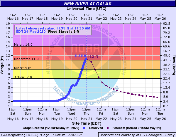
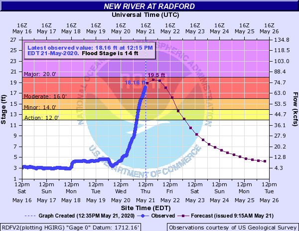
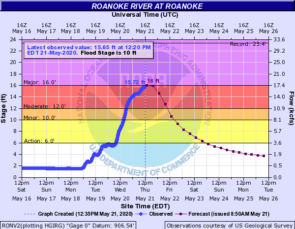
Four-day (96-hour) rainfall amounts ending at 800 AM EDT on May 22nd ranged from 3 to over 12” in the most favored locations. Some of the 11-inch+, 4-day rain totals in Roanoke County were within the 200-year recurrence interval (9.78” to 11.8”). The flooding that ensued was almost all in the form of river flooding that took several days to develop. Nearly every major river basin saw some flooding, but the most notable occurred in the New River basin where crests ranged from the 4th to 8th highest on record at the Virginia gaging stations along the river. Stages on the upper New were higher than in October 2018 when the remains of Hurricane Michael transited the region. At Galax, it was the highest stage in 25 years, since January 1995 when the river hit 15.23 feet. At Ivanhoe, it was the highest stage in over 40 years, since November, 1977 when the gage reached 28.08 feet. The incredible rainfall, runoff and numerous debris flows produced widespread damage to roads in the region with VDOT reporting over $5 million in damages. Of note as well during this period was that Philpott Dam on the Smith River which was completed by the U.S. Army Corps of Engineers in 1952 reached the highest pool elevation in its period of record, reaching 985.31 feet on May 22nd. This was the first time the emergency spillway elevation of 985 feet had been reached. The previous high lake level was 983.06 feet in June 1972 during Hurricane Agnes. |
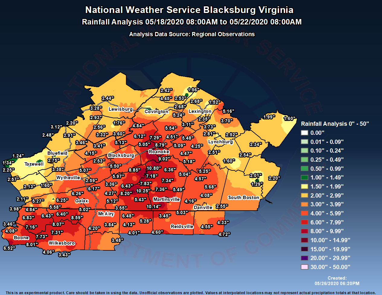 Total Rainfall from This Event |
Flooding
Many river basins saw flooding, with moderate to major flooding along the New and Roanoke River basins.
Hydrographs/Radar
 |
 |
 |
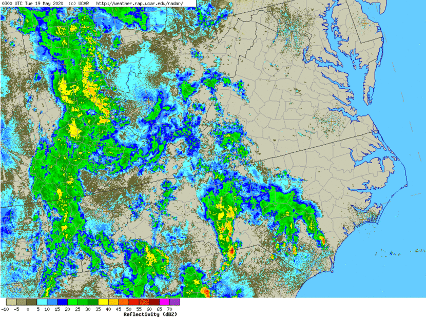 |
| Galax, VA along the New River | Radford, VA along the New River | Roanoke, VA along the Roanoke River | Radar Loop from May 19-21st |
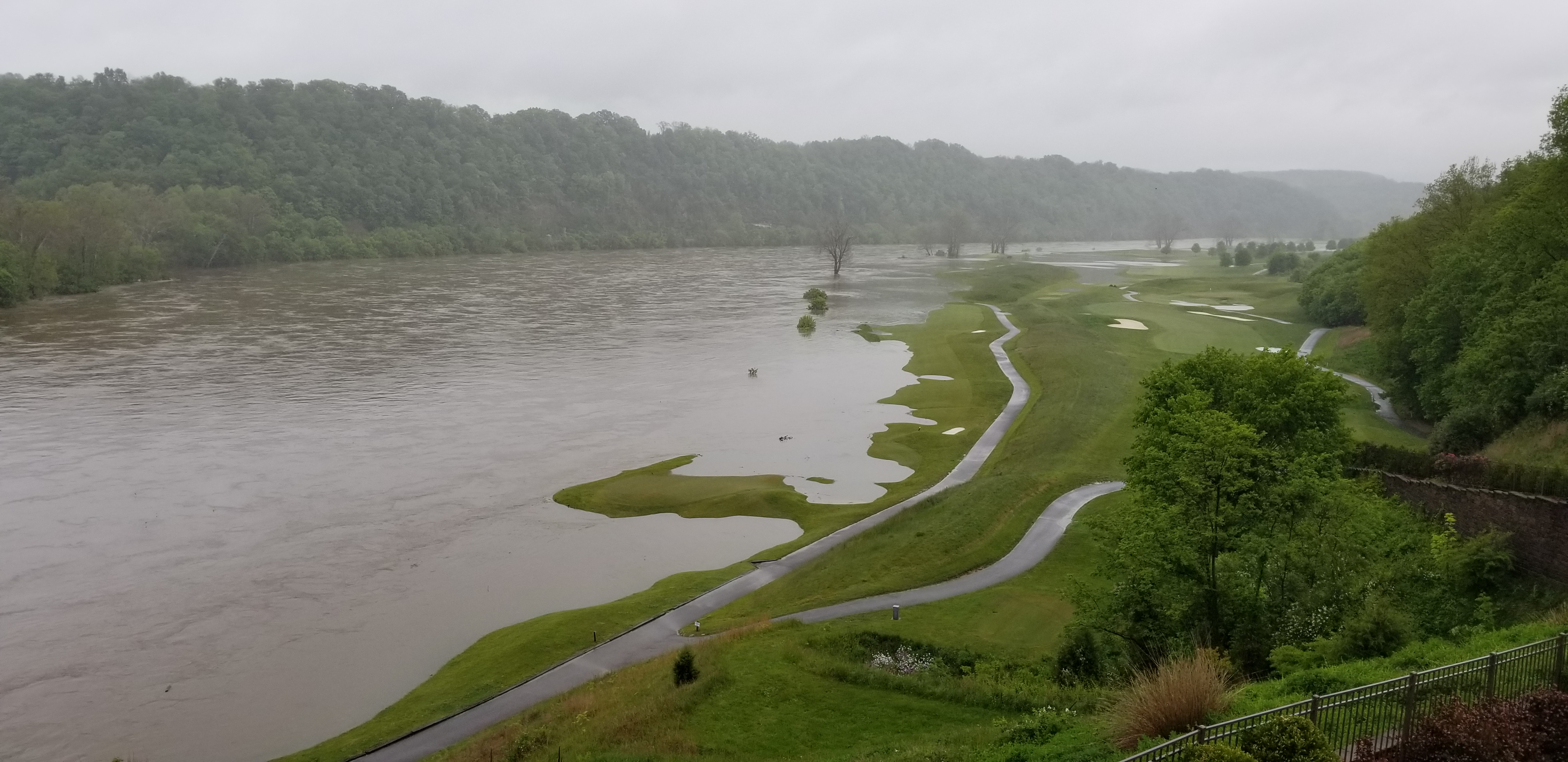
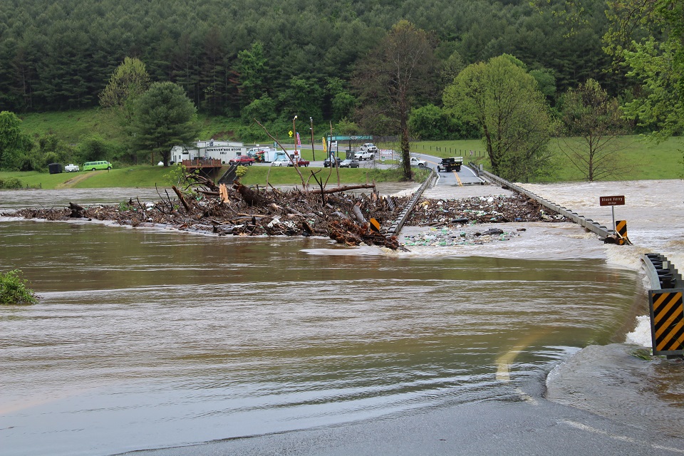
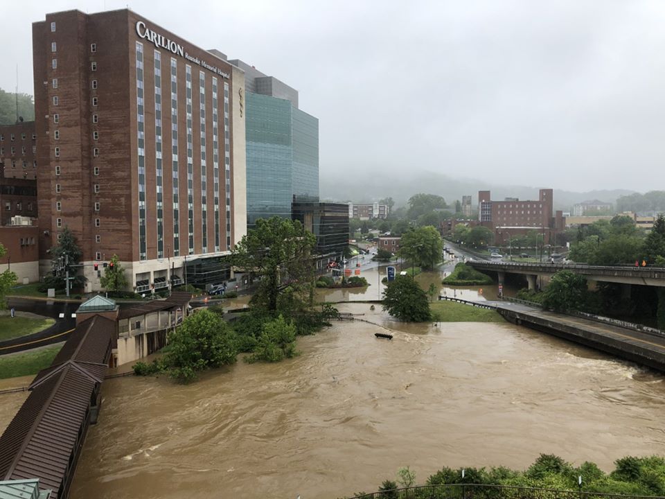
Photos
 |
 |
 |
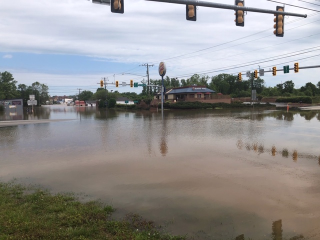 |
| New River near Radford, VA May 21st (credit : Keighton) | Fries, Va Flooding May 21st (credit: Danny Cox) |
Roanoke River in Roanoke, VA (credit: Taj Simmons WSLS) |
South Boston, VA flooding along U.S,58/501 intersection May 23rd (credit: William Stafford WSET) |
Storm Reports
THE FOLLOWING IS A LIST OF UNOFFICIAL PRECIPITATION TOTALS
OF 1 INCH OR MORE FOR THE RAIN EVENT FROM THIS PAST WEEK.
THESE REPORTS ARE FROM A COMBINATION OF SOURCES INCLUDING
COOP OBSERVERS...SPOTTERS...IFLOWS GAGES...AND
AUTOMATED EQUIPMENT AND HAVE NOT BEEN QUALITY CONTROLLED.

Location                     Amount     Provider

...North Carolina...

...Alleghany County...
Glade Creek VFD              9.96 in    DCP
Sparta 3.5 SSW               8.73 in    COCORAHS
1.9 SW Barrett               8.59 in    HADS
Sparta 2.8 NE                7.37 in    COCORAHS
Sparta 3.6 NW                6.40 in    COCORAHS
Ennice                       5.02 in    CWOP

...Ashe County...
Fleetwood                    8.78 in    COCORAHS
Transou                      8.62 in    COOP
2 NE Deep Gap                7.73 in    COCORAHS
West Jefferson 1.4 SE        7.16 in    COCORAHS
Jefferson 2 E                6.87 in    COOP
Lansing                      6.83 in    HADS
Jefferson                    6.43 in    AWOS
2 SW Ashland                 5.46 in    COCORAHS
1 W Nella                    5.41 in    COCORAHS
Nc Fire Raws No. 5           3.98 in    RAWS

...Caswell County...
Caswell Game Lands           5.30 in    RAWS
1.1 NE Topnot                4.85 in    COOP
Mebane 11.2 N                4.74 in    COCORAHS
Yanceyville 2.4 SW           3.93 in    COCORAHS

...Rockingham County...
Eden                         6.03 in    COOP
2.7 NW Reidsville            5.62 in    COOP
Eden 2.3 ENE                 5.41 in    COCORAHS
Reidsville                   4.30 in    AWOS

...Stokes County...
Lawsonville                  6.48 in    Public
Danbury                      6.45 in    COOP
0.9 E Pine Hall              6.20 in    HADS
King 4.2 N                   4.61 in    COCORAHS
King                         4.57 in    COOP
3 W Capella                  4.13 in    AWS


...Surry County...
Raven Knob                   6.61 in    RAWS
Elkin                        5.05 in    COOP
Pilot Mountain               4.25 in    COCORAHS
Mount Airy Surry             4.06 in    AWOS
Pilot Mountain               3.84 in    RAWS
Mt. Airy 4.3 W               3.20 in    COCORAHS

...Watauga County...
1 E Seven Devils            10.51 in    COCORAHS
Boone 4.5 SE                10.29 in    COCORAHS
Seven Devils                 9.72 in    COCORAHS
1 SE Rutherwood              8.93 in    COCORAHS
Boone 1 SE                   8.51 in    COOP
Boone 0.3 WSW                7.41 in    COCORAHS
Blowing Rock 2.2 NE          7.11 in    COCORAHS
Blowing Rock                 6.52 in    CWOP
1 N Foscoe                   5.92 in    COCORAHS
Boone Watauga Ct             5.66 in    AWOS
Boone                        5.29 in    COCORAHS
Boone Precip 2s              5.08 in    USGS
Valle Crucis                 5.03 in    COCORAHS
Boone                        4.38 in    CWOP
0.7 NE Rominger              4.10 in    HADS
Brushy Fork                  4.08 in    CWOP
Reese                        3.46 in    COCORAHS
Beech Mountain               2.78 in    CWOP

...Wilkes County...
2 SSE Wilbar                 7.87 in    RAWS
North Wilkesboro 5.5 SE      7.08 in    COCORAHS
Millers Creek 1.9 NNW        6.03 in    COCORAHS
Elkville                     5.88 in    HADS
W Kerr Scott Resv            5.30 in    COOP
0.6 SW North Wilkesboro      5.13 in    COOP
Moravian Falls               3.43 in    CWOP

...Yadkin County...
3.1 E Shacktown              4.07 in    COOP
Yadkinville 0.2 E            3.89 in    COCORAHS

...Virginia...

...Alleghany County...
Covington 4.1 E              4.01 in    COCORAHS
5.0 SE Covington City        3.04 in    IFLOWS
Covington                    2.18 in    COOP
1.2 S Callaghan              1.64 in    IFLOWS

...Amherst County...
3 NW Amherst                 3.70 in    Public
Amherst 1.7 SW               3.47 in    COCORAHS
Madison Heights 4.1 NW       2.95 in    COCORAHS

...Appomattox County...
Appomattox                   2.82 in    COOP

...Bath County...
1 ESE Hot Springs            6.13 in    IFLOWS
Hot Springs                  3.17 in    COOP
Lime Kiln                    2.95 in    RAWS
Goshen 3.3 WNW               2.07 in    COCORAHS
Millboro 0.3 NW              1.66 in    COCORAHS
Ingalls Field Airport        1.65 in    AWOS

...Bedford County...
Vinton 8.6 ENE               6.64 in    COCORAHS
Moneta 3.6 SW                6.27 in    COCORAHS
Goodview 3.2 SSE             6.27 in    COCORAHS
3.6 SW Huddleston            6.22 in    COOP
Bedford                      5.67 in    COOP
Goodview 1.7 NNE             5.24 in    COCORAHS
Bedford 3.2 W                5.23 in    COCORAHS
Moneta 4.8 S                 4.96 in    COCORAHS
Big Island 2.5 WNW           4.67 in    COCORAHS
Big Island                   4.67 in    COOP
Moneta                       3.38 in    CWOP


...Bland County...
Bland                        3.67 in    HADS
Bastian/Clear Fork           3.08 in    HADS


...Botetourt County...
Cloverdale                   7.75 in    IFLOWS
North Fork Catawba Creek     7.40 in    IFLOWS
6 E New Castle               7.29 in    Trained Spotter
Fincastle 1.9 NNW            6.83 in    COCORAHS
0.7 E Troutville             6.75 in    IFLOWS
1 SW Blue Ridge              4.08 in    Public

...Buckingham County...
Buckingham                   2.65 in    COOP
Buckingham 9.9 NW            2.32 in    COCORAHS
New Canton 2.6 SE            1.91 in    COCORAHS

...Campbell County...
Brookneal                    3.86 in    COOP
Lynchburg 6.7 ESE            2.95 in    COCORAHS
Lynchburg                    2.94 in    ASOS
Concord 4 SSW                2.75 in    COOP


...Carroll County...
Galax Water Plant            6.94 in    COOP
Hillsville 3.7 W             6.50 in    COCORAHS
Galax 6.1 N                  6.31 in    COCORAHS
0.6 W Laurel Fork            5.33 in    HADS
Hillsville Galax             5.11 in    AWOS
Woodlawn                     3.93 in    CWOP
Hillsville                   3.83 in    CWOP

...Charlotte County...
Charlotte Court House        2.42 in    COCORAHS
Keysville                    2.27 in    COOP
Saxe 4.3 SE                  2.25 in    COCORAHS

...City of Buena Vista County...
Buena Vista City             2.35 in    COOP

...City of Danville County...
Danville Airport             4.54 in    ASOS


...City of Lynchburg County...
Lynchburg 2.5 WSW            3.41 in    COCORAHS
Lynchburg 3.4 NNW            2.19 in    COCORAHS

...City of Martinsville County...
1.5 N Martinsville City      6.63 in    COOP

...City of Radford County...
Radford 0.9 WNW              4.66 in    COCORAHS

...City of Roanoke County...
2 ENE Cave Spring            9.02 in    Trained Spotter
2.1 SE Hollins               8.79 in    IFLOWS
Roanoke                      6.86 in    ASOS
2 NNE Cave Spring            5.00 in    Public

...City of Salem County...
2 NNE Salem City             11.39 in   Public
Salem 1.6 WSW                 9.20 in   COCORAHS
0.6 W Salem City              4.11 in   IFLOWS

...Craig County...
New Castle                    7.42 in   COOP
Craig Valley                  6.54 in   RAWS
Johns Creek/Route 311         6.78 in   IFLOWS
Craig Creek/Abbott            6.11 in   IFLOWS
Simmonsville                  5.12 in   IFLOWS

...Floyd County...
Copper Hill 6.2 S            13.66 in   COCORAHS
5 SE Check                   12.45 in   COCORAHS
3 WNW Callaway               10.80 in   Public
Copper Hill                   8.92 in   COOP
4 SE Terrys Fork              8.85 in   Trained Spotter
Willis 2.7 SE                 6.77 in   COCORAHS
Floyd 5.2 NW                  5.41 in   COCORAHS
2 S Terrys Fork               5.50 in   Public
2.3 N Copper Hill             5.23 in   IFLOWS
Floyd                         4.59 in   CWOP
5 WSW Callaway                4.00 in   Cocorahs
0.6 N Willis                  3.36 in   HADS

...Franklin County...
Rocky Mount 2.2 NW          11.86 in    COCORAHS
Ferrum 1.9 SSW               9.53 in    COCORAHS
Ferrum 2.7 SW                9.26 in    COCORAHS
Rocky Mount 3.6 W            8.80 in    COCORAHS
Adney Gap                    8.58 in    IFLOWS
Boones Mill                  8.54 in    COCORAHS
Wirtz 5.4 NE                 8.21 in    COCORAHS
Ferrum                       7.94 in    IFLOWS
Rocky Mount 10.3 NE          7.94 in    COCORAHS
Rocky Mount                  7.80 in    COOP
2.2 NW Snow Creek            7.45 in    IFLOWS
Rocky Mount 8.5 S            7.34 in    COCORAHS
Union Hall 2.9 E             5.04 in    COCORAHS
Hardy                        3.69 in    CWOP

...Giles County...
2.2 NE Mountain Lake         7.95 in    IFLOWS
Dismal                       5.51 in    IFLOWS
North Fork Stony Creek       5.24 in    IFLOWS
Pearisburg 4 SSE             4.46 in    COOP
1.5 N Kire                   3.60 in    IFLOWS
Pembroke 1.3 NNE             3.41 in    COCORAHS
Butt Mountain                3.08 in    IFLOWS


...Grayson County...
Fries                        6.26 in    Trained Spotter
3 SSW Elk Creek              6.25 in    Trained Spotter
Grayson Highlands            6.19 in    IFLOWS
Independence 1.3 S           6.08 in    COCORAHS
2.8 W Rugby                  5.83 in    IFLOWS
3.0 NE Baywood               3.31 in    HADS


...Halifax County...
1.1 E South Boston           4.65 in    COOP
South Boston                 3.06 in    AWOS
Clover                       2.01 in    CWOP
3.6 NE Mt Laurel             1.29 in    HADS

...Henry County...
2.0 E Horse Pasture         10.53 in    IFLOWS
Sanville                     9.94 in    IFLOWS
Philpott Dam                 9.58 in
Bassett 1.1 E                8.93 in    COCORAHS
Martinsville FP              7.73 in    COOP
Blue Ridge Airport           7.46 in    AWOS
2.7 W Bassett                5.01 in    HADS
3.2 W Fieldale               4.85 in    IFLOWS
2.7 E Martinsville Airport   3.73 in    IFLOWS

...Montgomery County...
Poor Mountain                7.22 in    IFLOWS
2 ESE Christiansburg         7.00 in    Trained Spotter
Christiansburg 1.3 W         6.41 in    COCORAHS
Blacksburg 1.6 NNE           5.97 in    COCORAHS
Blacksburg 1.3 ESE           5.23 in    COCORAHS
4.3 SE Elliston-Lafayette    5.84 in    IFLOWS
Blacksburg NWS               5.47 in    NWS
Blacksburg 2.4 ENE           5.47 in    COCORAHS
Blacksburg 1.6 W             5.30 in    COCORAHS
Christiansburg               4.78 in    COOP
Blacksburg 5.0 W             4.55 in    COCORAHS
Christiansburg 1.1 ESE       4.47 in    COCORAHS


...Patrick County...
Woolwine 0.4 SW              12.20 in   COCORAHS
1.3 SE Woolwine              11.90 in   COOP
2 SW Meadows of Dan          8.20 in    Public
5 ESE Buffalo Ridge          7.25 in    Public
4.3 SW Buffalo Ridge         6.95 in    IFLOWS
4 ESE Buffalo Ridge          6.57 in    Trained Spotter
Meadows of Dan 4.5 SW        5.80 in    COCORAHS
Meadows Of Dan 5 SW          5.60 in    COOP


...Pittsylvania County...
Pittsville 4.5 NNW           6.50 in    COCORAHS
Chatham                      5.68 in    COOP
Gretna 8.7 WNW               4.57 in    COCORAHS
5 NE Cascade                 4.16 in    Public
Chatham 5.9 SW               4.08 in    COCORAHS
Danville Regional Airport    3.91 in    ASOS
Danville                     2.55 in    CWOP

...Pulaski County...
Pulaski 2 E                  5.71 in    COOP
Dublin 2.0 SSW               5.23 in    COCORAHS
New River 0.6 NW             4.81 in    COCORAHS
Fairlawn 1.8 WNW             4.72 in    COCORAHS


...Roanoke County...
Roanoke 5.9 WSW             11.34 in    COCORAHS
Roanoke 5.8 SW              11.13 in    COCORAHS
Cave Spring 2.4 SSW         11.09 in    COCORAHS
Roanoke 9.3 SW              11.02 in    COCORAHS
Peters Creek                10.96 in    IFLOWS
Roanoke 5.5 SW              10.85 in    COCORAHS
Roanoke 4.3 SW              10.39 in    COCORAHS
Sugar Loaf                  10.06 in    IFLOWS
2 W Poages Mill              9.78 in    Cocorahs
1 SSW Cave Spring            9.75 in    Public
1.3 N Hollins                9.62 in    COOP
Roanoke Airport              9.21 in    ASOS
Roanoke 3.4 SW               9.10 in    COCORAHS
Salem 3.4 WNW                8.92 in    COCORAHS
4 NW Roanoke Airport         8.20 in    Public
Bent Mountain                7.09 in    CWOP
3 N Bradshaw                 5.05 in    Public


...Rockbridge County...
Irish Gap                    7.48 in    IFLOWS
Lexington 11.5 WSW           6.60 in    COCORAHS
3.6 NE Alto                  5.16 in    IFLOWS
Glenped                      3.83 in    RAWS
Lexington 8.6 NW             3.83 in    COCORAHS
4.4 SW Collierstown          2.29 in    IFLOWS
Fairfield                    1.52 in    CWOP

...Smyth County...
Saltville                    5.42 in    TVA
2.8 E Konnarock              4.32 in    HADS
0.8 SW Allison Gap           2.68 in    COOP
Marion 2.4 ENE               2.13 in    COCORAHS
2.3 S Nebo                   1.60 in    IFLOWS

...Tazewell County...
Richlands                    3.34 in    TVA
Bastian Clear Fork           2.75 in    HADS
0.9 SE Burkes Garden         2.45 in    COOP
3 WNW Tazewell               1.87 in    COCORAHS
Falls Mills 1.6 SW           1.77 in    COCORAHS
Richlands                    1.59 in    COOP
1.4 E Raven                  1.34 in    HADS
0.9 E Jewell Ridge           1.24 in    IFLOWS
2.3 W Tazewell               1.24 in    HADS
Gratton                      1.00 in    IFLOWS

...Wythe County...
Caseknife Station            5.56 in    IFLOWS
1 WSW Ivanhoe                5.50 in    Public
Wytheville                   4.68 in    COOP
Stony Fork                   3.92 in    RAWS
Max Meadows                  2.59 in    CWOP

...West Virginia...

...Greenbrier County...
0.9 W Meadow Bluff           3.48 in    IFLOWS
Alderson                     3.11 in    IFLOWS
Williamsburg VFD             2.34 in    IFLOWS
White Sulphur Springs        2.23 in    COOP
Lewisburg 3 N                1.68 in    COOP


...Mercer County...
Egeria                       3.80 in    IFLOWS
Willowton                    3.76 in    HADS
Bluefield                    3.47 in    COOP
5.9 NE Wenonah               3.12 in    IFLOWS
Arista                       2.96 in    IFLOWS
Bluefield                    2.88 in    ASOS

...Monroe County...
2.0 N Red Sulphur Spring     4.39 in    HADS
2.9 SE Raines Corner         3.70 in    HADS
Alderson 0.8 SSW             3.28 in    COCORAHS
Greenville 1 SE              2.56 in    COOP
0.6 NE Union                 2.44 in    IFLOWS

...Summers County...
4.1 NW Alderson              5.12 in    IFLOWS
Pipestem                     3.49 in    RAWS
2.3 W Ellison                3.16 in    IFLOWS
2.8 S Ellison                2.43 in    HADS
 |
Media use of NWS Web News Stories is encouraged! Please acknowledge the NWS as the source of any news information accessed from this site. |
|

