
Heavy to excessive rainfall is forecast over north Texas into Oklahoma Tuesday. Locally catastrophic flooding will be possible across portions of southwest Oklahoma. Flood Watches have been issued. Scattered severe thunderstorms are possible within a broad swath from the lower Great Lakes to the southern High Plains Tuesday afternoon into the evening. Read More >
Quick Synopsis:
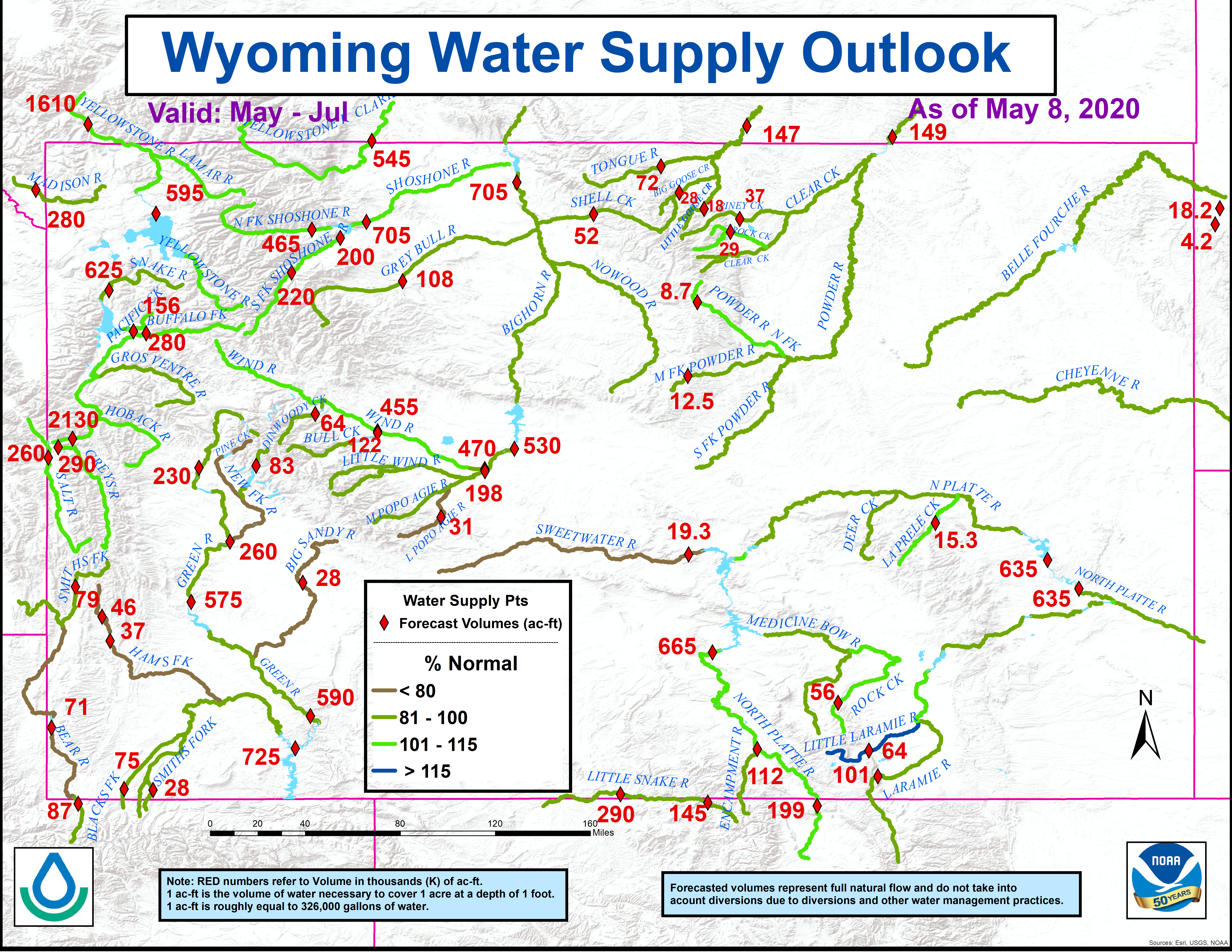
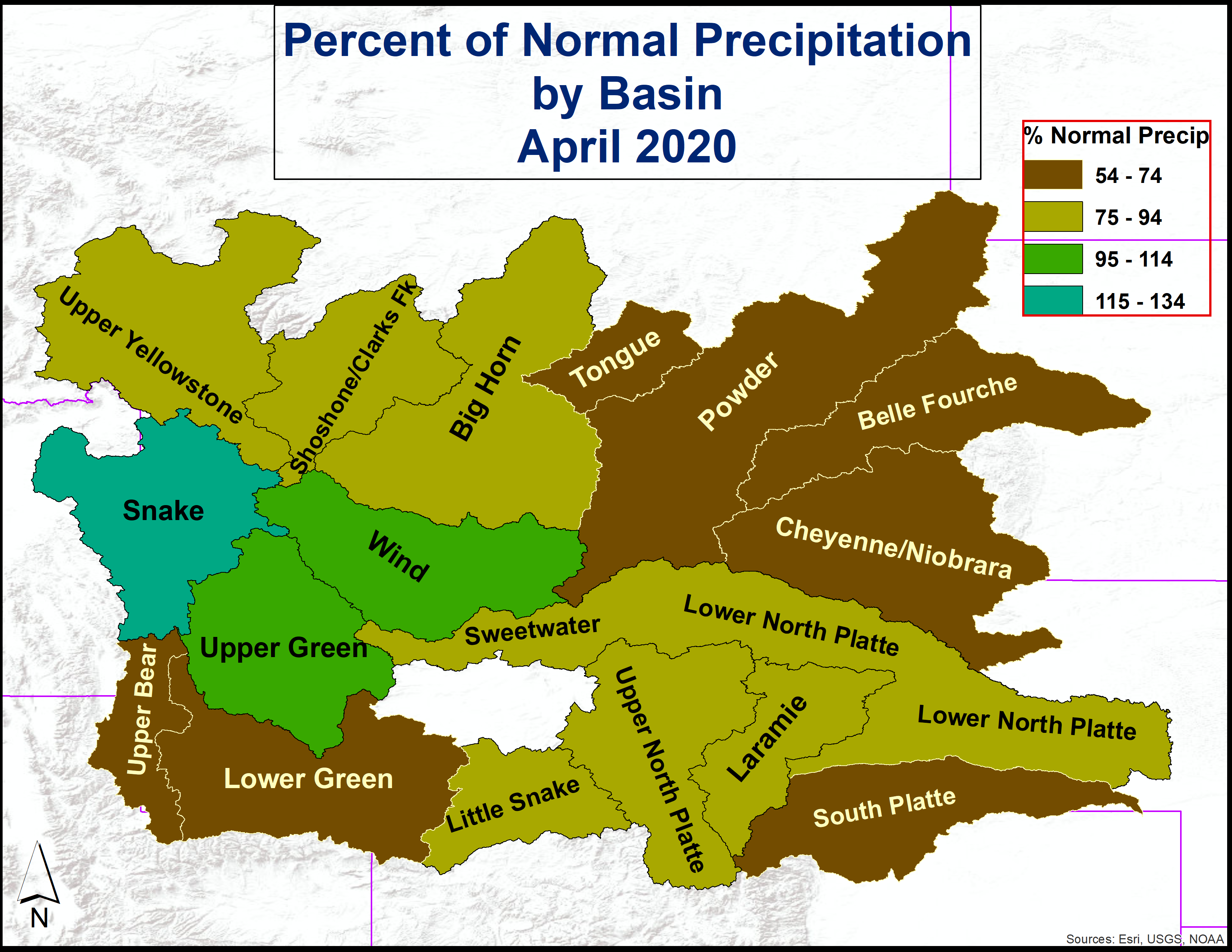
Mountain sowpack and associated snow water equivalents (SWEs) across central to southern Wyoming were above average by early May; while SWEs across western through northwestern Wyoming basins were generally below average. SWEs at the peak snowmelt runoff elevations (8,500’ – 10.000’) were the highest across the Laramie Basin at 125 to 135 percent of median. The Snake and Shoshone River Drainages had SWEs at 75 to 80 percent of median at the peak snowmelt runoff elevations.
This outlook is based on various diverse hydrological factors such as snow water equivalents (SWEs) in the mountain snowpack, basin morphology (i.e. how basins respond to snowmelt runoff), antecedent soil moisture, amount of bark beetle kill, low elevation snow depths, and likely temperature and precipitation trends during the late spring through early summer.
HIGHLIGHTS:
…Moderate to High potential for flooding associated with snowmelt is expected across lower portions of the Laramie, Upper North Platte, and Little Wind Basins…
…Moderate potential for snowmelt flooding is expected over the Encampment River (Riverside)Watershed and lower sections of the Big Wind River Watershed…
…All other of headwater basins across Wyoming can expect a generally Low potential for flooding due to springtime snowmelt...
This is the LAST outlook for Spring 2016.
*****************************************************************************************
Other hydrological information for Wyoming can be found at the NOAA hydrology website:
https://www.weather.gov/riw/local_hydrology
Monthly Wyoming Hydrologic Summary and Graphics:
(updated monthly around the 15th of every month)
https://www.weather.gov/media/riw/hydro/hydro_report.pdf
Wyoming Drought Information Page:
(updated at least once a month)
https://www.weather.gov/riw/drought
Wyoming Graphical Water Supply Outlook:
(updated by the 10th of every month—January-June)
https://www.weather.gov/images/riw/hydro/watersupply.png
Wyoming Average Precipitation by Basin:
(updated monthly)
https://www.weather.gov/images/riw/hydro/wyomingprecip.png
Wyoming Spring Snowmelt Runoff Flood Potential Graphic:
(updated around the 20th of the month---February-May)
https://www.weather.gov/images/riw/hydro/floodoutlook.png
Current and Forecast Wyoming Streamflows and/or River Stages:
https://water.weather.gov/ahps2/index.php?wfo=RIW
https://water.weather.gov/ahps2/index.php?wfo=CYS
https://waterdata.usgs.gov/wy/nwis/rt
**************************************************************************************************
The current Wyoming Spring 2016 Snowmelt Runoff Flood Potential Outlook graphic:


