
Heavy rain and widely scattered severe storms capable of large hail, damaging winds, and possibly a tornado are expected over portions of the central and southern Plains into the Lower Missouri Valley. Unseasonable warmth will continue for a few more days across the Midwest and Southeast where several daily record highs could fall. Read More >
Overview
|
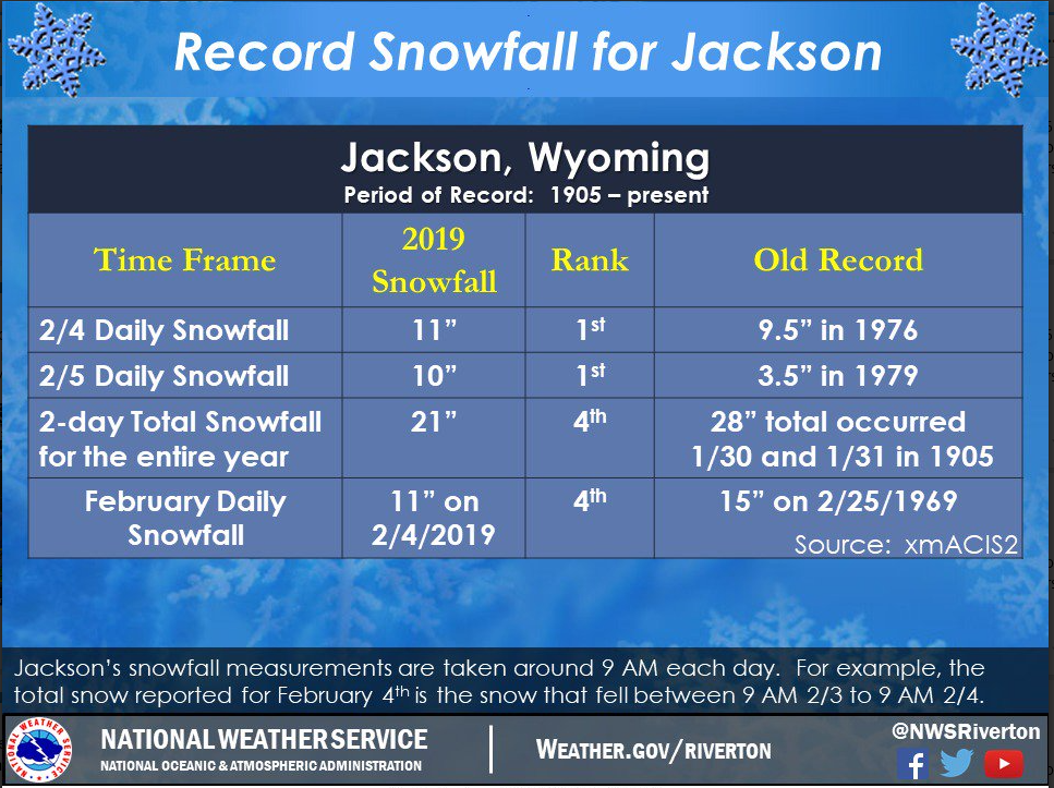
A series of Pacific Winter Storms moved across Western Wyoming starting Saturday morning and ending Wednesday morning. These latest systems dumped 15 to over 30 inches of new snow in the western mountains and over foot in many western valley locations.This also helped set a couple of daily snowfall records at Jackson, WY. |
 Final Snowfall Totals for February 2-6, 2019 (Click to Enlarge) |
Public Information Statement
National Weather Service Riverton WY
1112 AM MST Wed Feb 6 2019

...Snowfall Totals for Saturday through Early Wednesday Morning...

A series of Pacific storm systems over the course of several days
produced impressive snowfall totals across far western Wyoming. The
snow begin falling Saturday morning and continued through Tuesday
night with only a few periodic breaks in the snowfall. For many
locations the heaviest snow fell Monday morning and again Monday
night. The snow accumulations reflected here are the totals from
Saturday morning, February 2, through early Wednesday morning,
February 6.

Observations are collected from a variety of sources with varying
equipment and exposures. We thank all volunteer weather observers
for their dedication. Not all data listed are considered official.

Note: SnoTELS (Snow Telemetry) are remote sensing sites in high
mountain watersheds. Snowfall data from SNOTELS are estimated based
on snow water equivalent.

Location                              Snowfall

Big Horn County...
 Deaver...                            1 inch.

Fremont County...
 Deer Park Snotel...                 23 inches.
 Brooks Lake...                      18 inches.
 Hobbs Park Snotel...                16 inches.
 South Pass Snotel...                15 inches.
 St. Lawrence Alt Snotel...          10 inches.
 Townsend Creek Snotel...            10 inches.
 Atlantic City...                   7.4 inches.
 Cold Springs Snotel...               6 inches.
 Burroughs Creek Snotel...            5 inches.
 Dubois...                            4 inches.
 Little Warm Snotel...                3 inches.
 Castle Creek Snotel...               2 inches.
 6 SW Lander...                     0.3 inches.

Hot Springs County...
 Owl Creek Snotel...                  2 inches.

Johnson County...
 Buffalo...                         0.9 inches.
 17 E Kaycee...                     0.5 inches.
 4 SSW Buffalo...                   0.5 inches.
 13 SSE Buffalo...                  0.5 inches.

Lincoln County...
 Commissary Ridge...                 28 inches.
 Blind Bull Summit...                20 inches.
 2 SE Thayne...                    17.7 inches.
 Blind Bull Summit Snotel...         17 inches.
 Cottonwood Creek Snotel...          17 inches.
 Box Y Ranch...                      16 inches.
 Spring Creek Divide Snotel...       16 inches.
 5 NNE Thayne...                   14.5 inches.
 Willow Creek Snotel...              14 inches.
 Salt River Summit Snotel...         13 inches.
 5 SSE Smoot...                    12.5 inches.
 Star Valley Ranch...              12.2 inches.
 Indian Creek Snotel...              10 inches.
 Kelley Ranger Station Snotel...      8 inches.
 Hams Fork Snotel...                  8 inches.
 Afton...                           7.4 inches.
 3 SE Bedford...                      7 inches.
 Alpine...                            5 inches.
 Fossil Butte...                      5 inches.
 3 S Fontenelle Dam...                1 inch.

Natrona County...

Park County...
 Pahaska...                          12 inches.
 Kirwin Snotel...                    10 inches.
 Blackwater Snotel...                 6 inches.
 Beartooth Lake Snotel...             6 inches.
 Younts Peak Snotel...                6 inches.
 Evening Star Snotel...               3 inches.
 Marquette Snotel...                  3 inches.
 Wolverine Snotel...                  2 inches.
 26 SW Cody...                      1.5 inches.
 3 NE Sunshine...                   0.7 inches.
 2 WSW Cody...                      0.5 inches.
 4 ENE Powell...                    0.4 inches.
 4 SW Powell...                     0.3 inches.
 Meeteetse...                       0.2 inches.

Sublette County...
 Triple Peak Snotel...               23 inches.
 Big Sandy Opening Snotel...         14 inches.
 Larsen Creek Snotel...              14 inches.
 Loomis Park Snotel...               12 inches.
 Bondurant...                        11 inches.
 Gunsite Pass Snotel...              11 inches.
 Snider Basin Snotel...              11 inches.
 East Rim Divide Snotel...           10 inches.
 New Fork Lake Snotel...             10 inches.
 Pocket Creek Snotel...              10 inches.
 Kendall Ranger Station Snotel...     9 inches.
 14 NW Pinedale...                  7.3 inches.
 Elkhart Park G.S. Snotel...          7 inches.
 Pinedale...                        6.7 inches.
 Daniel Fish Hatchery...            6.2 inches.
 Boulder Rearing Station...           3 inches.

Sweetwater County...
 Wamsutter...                         4 inches.
 2 NNE Farson...                      2 inches.
 Rock Springs...                    1.8 inches.
 4 NNW Rock Springs...              1.7 inches.
 Green River...                0.7 to 1 inch.

Teton County...
 Jackson Hole - Rendezvous Bowl...   49 inches.
 Jackson Hole - Raymer...            45 inches.
 Jackson Hole - Mid Mountain...      44 inches.
 1 ENE Teton Village...            38.5 inches.
 Phillips Bench Snotel...            34 inches.
 3 SSW Wilson...                     34 inches.
 5 NW Jackson...                     34 inches.
 Jackson Hole - Base...              33 inches.
 Grand Targhee - Chief Joseph...     31 inches.
 6 NW Moose...                       30 inches.
 Snow King...                        30 inches.
 Jackson...                        26.5 inches.
 Grand Targhee Snotel...             25 inches.
 Granite Creek Snotel...             24 inches.
 Moose...                          18.5 inches.
 Base Camp Snotel...                 18 inches.
 Grassy Lake Snotel...               15 inches.
 Togwotee Pass Snotel...             15 inches.
 1 NNW Alta...                       14 inches.
 Togwotee Mountain Lodge...          14 inches.
 Snake River Stn Snotel...           13 inches.
 Jackson Dam...                    11.6 inches.
 Gros Ventre Summit Snotel...        10 inches.
 Darwin Ranch...                    9.5 inches.

Washakie County...
 16 SSE Ten Sleep...                0.5 inches.

Yellowstone National Park...
 Lewis Lake Divide Snotel...         24 inches.
 Old Faithful Ranger Station...      22 inches.
 Snake River Ranger Station...     21.6 inches.
 Thumb Divide Snotel...              19 inches.
 Two Ocean Plateau Snotel...         16 inches.
 Yellowstone East Entrance...        11 inches.
 Sylvan Lake Snotel...                9 inches.
 Canyon Snotel...                     8 inches.
 Sylvan Road Snotel...                7 inches.
 Parker Peak Snotel...                7 inches.
 Mammoth...                         6.5 inches.
 Tower Falls Ranger Station...      3.1 inches.
 Lamar Ranger Station...            1.3 inches.

$$
 |
Media use of NWS Web News Stories is encouraged! Please acknowledge the NWS as the source of any news information accessed from this site. |
|



 Follow us on X
 Follow us on Facebook
 Follow us on YouTube
 RIW RSS Feed