A multi-day, potentially historic heavy rainfall event may produce catastrophic and life-threatening flooding through Saturday from the Ozarks into the Ohio River Valley. Several clusters of strong to severe storms are expected from the Southern Plains, Mid Mississippi Valley to the Ohio/Tennessee Valleys and the Mid Atlantic. Read More >
***While this page highlights the burn scar associated with the Horsethief Canyon Wildfire, these impacts can occur down slope and/or downstream of any burn area, big or small. Please contact local officials if you are unsure of your risk.***
 |
 |
 |
 |
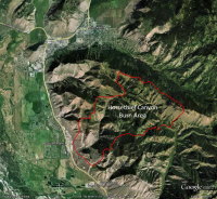
| Location of Horsethief Canyon Burn Scar |
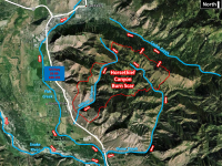
Overview of Horsethief Canyon Burn Scar General Location |
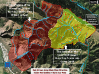
Horsethief Canyon Burn Scar Direction of Streamflow |
|
Greatest Risk Area
|

What should people who live near burn areas do to protect themselves from potential Flash Flooding and Debris Flows?
|