Western and Central Wyoming
Weather Forecast Office
***While this page highlights the burn scar associated with the Gilead Wildfire, these impacts can occur down slope and/or downstream of any burn area, big or small. Please contact local officials if you are unsure of your risk.***
|
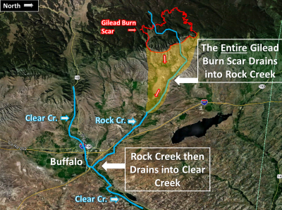
Greatest Risk Area
|

What should people who live near burn areas do to protect themselves from potential Flash Flooding and Debris Flows?
|
Forecasts
Severe Weather
Forecast Discussion
User Defined Forecast
Fire Weather
Activity Planner
Hourly Forecasts
Snow and Avalanche
Aviation Weather Decision Support
Hydrology
SnoTel Page
Rivers and Lakes
Weather Safety
NOAA Weather Radio
Preparedness
SkyWarn
StormReady
US Dept of Commerce
National Oceanic and Atmospheric Administration
National Weather Service
Western and Central Wyoming
12744 West U.S. Hwy 26
Riverton, WY 82501
307-857-3898
Comments? Questions? Please Contact Us.


