
Strong to severe thunderstorms may produce heavy to excessive rainfall over portions of the Central/Southern Plains and Mississippi Valley today. There is a Slight Risk (Level 2 of 4) for Excessive Rainfall and a Slight Risk (Level 2 of 5) for severe thunderstorms today. Elevated fire weather conditions are possible over parts of western Florida today. Read More >
Western and Central Wyoming
Weather Forecast Office
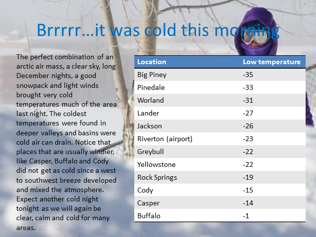
It was a chilly Tuesday night (Dec 30 - Dec 31) with extreme cold temperatures felt across western & central Wyoming. The cooperative site at Daniel in the Upper Green River Basin bottomed out at 48 below zero. Below is a quick summary of the lows that occurred Tuesday night.
 |
 |
| A complete listing of lows for December 31st. |
Forecasts
Severe Weather
Forecast Discussion
User Defined Forecast
Fire Weather
Activity Planner
Hourly Forecasts
Snow and Avalanche
Aviation Weather Decision Support
Hydrology
SnoTel Page
Rivers and Lakes
Weather Safety
StormReady
NOAA Weather Radio
Preparedness
SkyWarn
US Dept of Commerce
National Oceanic and Atmospheric Administration
National Weather Service
Western and Central Wyoming
12744 West U.S. Hwy 26
Riverton, WY 82501
307-857-3898
Comments? Questions? Please Contact Us.

