HOME
FORECAST
Local
Graphical
Aviation
Marine
Rivers and Lakes
Hurricanes
Severe Weather
Fire Weather
Sunrise/Sunset
Long Range Forecasts
Climate Prediction
Space Weather
PAST WEATHER
Past Weather
Heating/Cooling Days
Monthly Temperatures
Records
Astronomical Data
SAFETY
Floods
Tsunamis
Beach Hazards
Wildfire
Cold
Tornadoes
Air Quality
Fog
Heat
Hurricanes
Lightning
Rip Currents
Safe Boating
Thunderstorms
Space Weather
Sun (Ultraviolet Radiation)
Wind
Drought
Winter Weather
INFORMATION
Wireless Emergency Alerts
Weather-Ready Nation
Brochures
Cooperative Observers
Daily Briefing
Damage/Fatality/Injury Statistics
Forecast Models
GIS Data Portal
NOAA Weather Radio
Publications
SKYWARN Storm Spotters
StormReady
TsunamiReady
Service Change Notices
EDUCATION
Be A Force of Nature
NWS Education Home
NEWS
NWS News
Events
Pubs/Brochures/Booklets
NWS Media Contacts
SEARCH
Search For
NWS
All NOAA
ABOUT
About NWS
Organization
Strategic Plan
For NWS Employees
International
National Centers
Careers
Contact Us
Glossary
Social Media
Local forecast by
"City, St" or ZIP code
Sorry, the location you searched for was not found. Please try another search.
Multiple locations were found. Please select one of the following:
Location Help
News Headlines
Citizen Weather Observers needed across Wyoming - Join CoCoRaHS!
Customize Your
Weather.gov
Enter Your City, ST or ZIP Code
Remember Me
LOADING...
Western and Central Wyoming
Weather Forecast Office
Web Cams - Visibility Monitorings
Weather.gov
>
Western and Central Wyoming
> Web Cams - Visibility Monitorings
Current Hazards
Experimental Graphical Hazardous Weather Outlook
Storm and Precipitation Reports
Outlooks
Submit a Storm Report
Current Conditions
Satellite
Local Ice Accumulation Reports
Observations
Observed Precipitation
Snowfall Analysis
Local Storm Reports
Local Snowfall Reports
Radar
Local Standard Radar (low bandwidth)
Local Enhanced Radar
Regional Standard Radar (low bandwidth)
Forecasts
Hourly Forecasts
Experimental Heat Risk
Fire Weather
Winter Weather
Forecast Discussion
Experimental Probabilistic Quantitative Precipitation Forecast
Forecast Points
Avalanche Weather and Snow Recreation
DSS Forecast Images
Rivers and Lakes
National Water Prediction Service (NWPS)
Climate and Past Weather
Local
Event Summaries
NOAA Climate Service
Drought
Drought Information Statement
Local Climate Graphs
Local Programs
Publications
Blog
WFO Riverton Information
Our Office Staff
Text Products
Spring Frost & Freeze Information
Points of Interest - Bighorn National Forest
Points of Interest - Yellowstone and Grand Teton NPs
Wyoming Decision Support Page
Navigation Menu
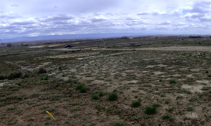
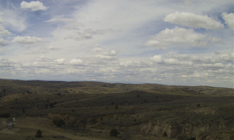
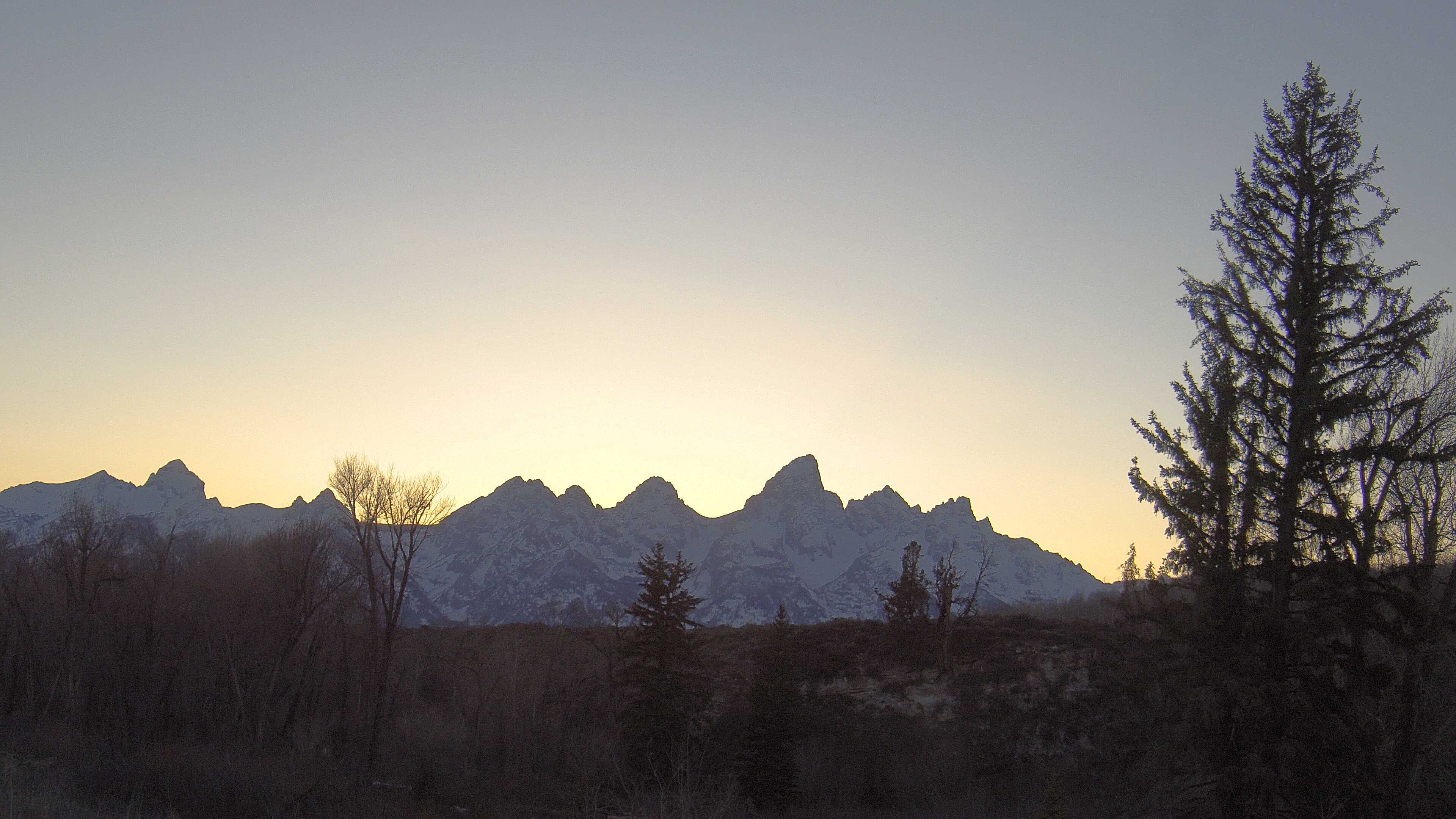
Click on Image to Enlarge
Basin | Northeast
West of Manderston
Fortification Creek | West
11 miles north of Exit 106 on I-90
Newcastle | East
Near U.S. Hwy 85 north of Newcastle
Carbon County | Northeast
10 miles southwest of Saratoga
Casper | Northeast
Highland Cemetery
Johnson County
13 miles northeast of Kaycee
Sheridan
Riverton | DEQ Mobile
Thunder Basin | Southwest
32 miles north of Gillette
Converse County | East
30 miles northwest of Douglas
Cheyenne NCore | East
Inside Cheyenne city limits
Laramie County
15 miles southeast of Cheyenne
Wamsutter | East
2 miles west of Wamsutter
Seedskadee NWR
East of Visitor Center
Moxa Arch | North
20 miles northwest of Green River
James Town | DEQ Mobile
South Pass | East
5 miles NE of South Pass City
Juel Spring | Northwest
20 miles northwest of Farson
Warbonnet | South
4 miles southwest of Boulder
Big Piney | North
4 miles south of Big Piney
Boulder | Northeast
4 miles southwest of Boulder
Pinedale | Northeast
Inside Pinedale city limits
Daniel | South
Grand Teton National Park | West
Teton Science School
Follow us on X
Follow us on Facebook
Follow us on YouTube
RIW RSS Feed