
A rare March heat wave is ongoing with much above-normal temperatures over the Southwest U.S. through this weekend. Periods of critical fire weather will persist from the central Rockies to the central and southern Plains through the weekend as gusty winds and low relative humidity continue. A Kona low will continue to bring several rounds of moderate to heavy rainfall to Hawaii through Sunday. Read More >
...Highlights of 2014...
| Element | Jan | Feb | Mar | Apr | May | Jun | Jul | Aug | Sep | Oct | Nov | Dec | Year |
| Average High | 33.7 | 36.1 | 47.0 | 57.0 | 68.4 | 77.2 | 88.6 | 84.2 | 76.6 | 66.8 | 41.3 | 38.2 | 59.2 |
| Mean High (1981-2010 Normals) | 35.2 | 37.8 | 47.9 | 56.8 | 67.1 | 78.8 | 88.1 | 86.4 | 74.3 | 59.4 | 44.7 | 34.2 | 59.3 |
| Average Low | 14.2 | 6.3 | 23.7 | 28.5 | 37.3 | 42.9 | 51.9 | 51.0 | 42.2 | 33.5 | 15.9 | 18.7 | 30.5 |
| Mean Low (1981-2010 Normals) | 14.3 | 15.7 | 22.4 | 28.6 | 37.2 | 45.7 | 53.0 | 51.5 | 41.4 | 31.0 | 21.6 | 13.5 | 31.4 |
| Average Temperature | 24.0 | 19.0 | 35.4 | 42.7 | 52.8 | 60.1 | 70.3 | 67.6 | 59.4 | 50.1 | 28.6 | 28.5 | 44.9 |
| Mean Average Temperature (1981-2010 Normals) | 24.7 | 26.7 | 35.2 | 42.7 | 52.2 | 62.2 | 70.5 | 69.0 | 57.9 | 45.2 | 33.2 | 23.8 | 45.4 |
| Departure from Normal | -0.7 | -7.7 | 0.2 | 0.0 | 0.6 | -2.1 | -0.2 | -1.4 | 1.5 | 4.9 | -4.6 | 4.7 | -0.5 |
| Rank - Coldest to Warmest 75 years of record (P.O.R 12/1939-2014) |
42 | 3 | 46 | 37 | 36 | 13 | 26 | 18 | 43 | 63 | 9 | 57 | 29 |
| Highest Daily Maximum | 43 | 56 | 64 | 74 | 92 | 92 | 100 | 95 | 92 | 77 | 72 | 60 | 100 |
| Date of Occurrence | 13,19 | 16 | 30 | 18 | 28 | 26 | 23 | 12 | 18 | 25 | 1 | 12 | 7/23 |
| Lowest Daily Minimum | -24 | -26 | -4 | 10 | 22 | 36 | 38 | 41 | 25 | 20 | -27 | -16 | -27 |
| Date of Occurrence | 5 | 6 | 1 | 14 | 1 | 5,9,15 | 2 | 24 | 12 | 30 | 12 | 30 | 11/12 |
| Number of Days with: | |||||||||||||
| Maximum >= 90° | 0 | 0 | 0 | 0 | 1 | 2 | 14 | 7 | 4 | 0 | 0 | 0 | 28 |
| Maximum <= 32° | 10 | 12 | 3 | 1 | 0 | 0 | 0 | 0 | 0 | 0 | 8 | 9 | 43 |
| Minimum <= 32° | 31 | 28 | 28 | 24 | 9 | 0 | 0 | 0 | 5 | 13 | 25 | 27 | 190 |
| Minimum <= 0° | 4 | 11 | 2 | 0 | 0 | 0 | 0 | 0 | 0 | 0 | 6 | 3 | 29 |
| Record Highs Set or Tied | 0 | 0 | 0 | 0 | 1 | 0 | 1 | 0 | 3 | 2 | 2 | 3 | 12 |
| Record Lows Set or Tied | 1 | 2 | 0 | 1 | 0 | 0 | 0 | 0 | 2 | 0 | 3 | 0 | 9 |
Temperature Ranks and Records:
Daily Records:
Max:May: 92 on the 28th.
July: 100 on the 23rd (tie).
September: 92 on the 18th, 90 on the 25th, 90 on the 26th (tie).
October: 77 on the 25th, 70 on the 31st (tie).
November: 72 on the 1st (also ties the all-time record high November), 58 on the 29th (tie).
December: 58 on the 11th (tie), 60 on the 12th, 57 on the 13th.
Record High So Early in the Season: 92 on May 28th:Min:
January: -24 on the 5th.
February: -26 on the 6th, -16 on the 25th.
Apil: 12 on the 13th
September: 26 on the 11th , 25 on the 12th.
November: -27 on the 12th (also an all-time record low for November), 25 on the 12th.
Record Lows So Early in the Season: 26 on September 11th, 25 on September 12th, -27 on November 12th.
| Coldest Months of February on Record | ||||
| Rank | Year | Average Temperature °F | ||
| 1 | 1989 | 11.9 | ||
| 2 | 1960 | 18.5 | ||
| 3 | 2014 | 19.0 | ||
| 4 | 1993 | 19.6 | ||
| 5 | 1942, 1985 | 19.7 | ||
| 7 | 1955 | 20.2 | ||
| 8 | 2011 | 20.6 | ||
| Top Ten Warmest Years on Record | |||||||
| Rank | Year | Average Temperature °F | |||||
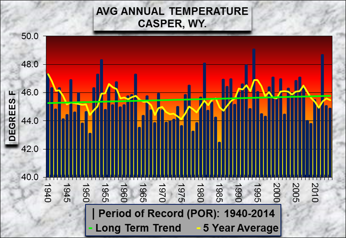
| 1 | 1994 | 49.1 | |||||
| 2 | 2012 | 48.7 | |||||
| 3 | 1954 | 48.3 | |||||
| 4 | 1981 | 48.1 | |||||
| 5 | 1992 | 48.0 | |||||
| 6 | 1940, 1953, 1963 | 47.3 | |||||
| 9 | 1999, 2006 | 47.1 | |||||
| 47 | 2014 | 44.9 | |||||
| Top Ten Coldest Years on Record | |||||||
| Rank | Year | Average Temperature °F | |||||
| 1 | 1985 | 42.5 | |||||
| 2 | 1951 | 43.1 | |||||
| 3 | 1978 | 43.2 | |||||
| 4 | 1964 | 43.5 | |||||
| 5 | 1975 | 43.6 | |||||
| 6 | 2009, 1979, 1968, 1949 | 43.8 | |||||
| 10 | 1971 | 43.9 | |||||
| 29 | 2014 | 44.9 | |||||
 |
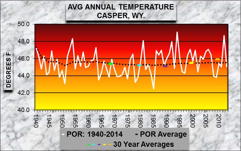 |
| Average Annual Temperature for Period of Record - Click on Graph to Enlarge | |

| Element | Jan | Feb | Mar | Apr | May | Jun | Jul | Aug | Sep | Oct | Nov | Dec | Year |
| Average Speed (MPH) | 15.5 | 12.4 | 13.7 | 11.5 | 10.6 | 10.1 | 8.4 | 8.5 | 10.0 | 10.8 | 12.9 | 13.0 | 11.4 |
| Maximum 3-sec Gust | 60 | 54 | 56 | 51 | 51 | 53 | 46 | 48 | 64 | 48 | 57 | 48 | 64 |
| Direction (tens of degrees) | 23 | 24 | 25 | 23 | 24 | 30 | 04 | 30 | 25 | 21 | 24 | 21 | 25 |
| Date of Occurrence | 11 | 19 | 17 | 18 | 31 | 4 | 15 | 30 | 8 | 15 | 29 | 24 | 9/8 |

| Element | Jan | Feb | Mar | Apr | May | Jun | Jul | Aug | Sep | Oct | Nov | Dec | Year |
| Total (inches) | 0.74 | 0.74 | 1.64 | 1.15 | 0.49 | 1.35 | 1.17 | 1.10 | 0.64 | 1.05 | 0.81 | 1.25 | 12.13 |
| Mean Precip (1981-2010 Normals) | 0.51 | 0.57 | 0.82 | 1.29 | 2.02 | 1.61 | 1.41 | 0.85 | 1.08 | 1.11 | 0.76 | 0.49 | 12.52 |
| Departure from Normal | 0.23 | 0.17 | 0.82 | -0.14 | -1.53 | -0.26 | -0.24 | 0.25 | -0.44 | -0.06 | 0.05 | 0.76 | -0.39 |
| Percent of Normal | 145 | 130 | 200 | 89 | 24 | 84 | 83 | 129 | 59 | 95 | 107 | 255 | 97 |
|
Rank - Driest to Wettest |
60 | 58 | 71 | 32 | 4 | 46 | 44 | 62 | 34 | 45 | 51 | 73 | 46 |
| Greatest 24-HR Total | 0.26 | 0.17 | 0.32 | 0.29 | 0.21 | 0.52 | 1.01 | 0.46 | 0.43 | 0.47 | 0.37 | 0.73 | 1.01 |
| Dates of Occurrence | 14 | 25 | 7 | 26-27 | 15-16 | 27 | 15-16 | 4-5 | 28-29 | 12 | 10-11 | 14-15 | 7/15-16 |
| Number of Days with: | |||||||||||||
| Precipitation >= 0.01 | 10 | 11 | 12 | 10 | 8 | 7 | 6 | 12 | 5 | 4 | 8 | 9 | 102 |
| Precipitation >= 0.10 | 2 | 3 | 7 | 6 | 2 | 5 | 2 | 4 | 3 | 3 | 2 | 4 | 43 |
| Precipitation >= 1.00 | 0 | 0 | 0 | 0 | 0 | 0 | 0 | 0 | 0 | 0 | 0 | 0 | 0 |
| Days with Thunderstorms | 0 | 0 | 0 | 0 | 2 | 9 | 3 | 5 | 4 | 0 | 0 | 0 | 23 |
| Daily Precipitaton Records Set or Tied | 1 | 0 | 1 | 0 | 0 | 1 | 0 | 0 | 0 | 1 | 1 | 1 | 6 |
Precipitation Ranks and Records:
One Day Precipitation Records:
January: 0.26 on the 14th (tie).
March: 0.32 on the 7th.
June: 0.52 on the 27th.
October: 0.47 on the 12th.
November: 0.35 on the 10th.
December: 0.49 on the 14th.
| Wettest Months of March on Record | ||||
| Rank | Year | Precipitation (inches) | ||
| 1 | 1954 | 2.43 | ||
| 2 | 1983 | 2.29 | ||
| 3 | 1958 | 2.27 | ||
| 4 | 1975 | 2.01 | ||
| 5 | 2014 | 1.64 | ||
| 6 | 1984 | 1.59 | ||
| Driest Montths of May on Record | ||||
| Rank | Year | Precpitation (inches) | ||
| 1 | 1966 | 0.30 | ||
| 2 | 1994 | 0.37 | ||
| 3 | 2009 | 0.43 | ||
| 4 | 2014 | 0.49 | ||
| 5 | 2003 | 0.51 | ||
| 6 | 1960 | 0.56 | ||
| Wettest Months of December on Record | ||||
| Rank | Year | Precipitation (inches) | ||
| 1 | 1982 | 3.71 | ||
| 2 | 2010 | 1.36 | ||
| 3 | 2014 | 1.25 | ||
| 4 | 2013, 1978 | 1.20 | ||
| 6 | 1985 | 1.05 | ||
| 7 | 1955 | 1.04 | ||
| Top Ten Driest Years on Record | |||||||
| Rank | Year | Precpitation (inches) | |||||
| 1 | 1988 | 6.56 | |||||
| 2 | 2001 | 6.76 | |||||
| 3 | 2002 | 7.05 | |||||
| 4 | 1960 | 7.34 | |||||
| 5 | 1954 | 7.70 | |||||
| 6 | 2012 | 7.88 | |||||
| 7 | 1963 | 7.90 | |||||
| 8 | 1966 | 8.14 | |||||
| 9 | 1943 | 8.91 | |||||
| 10 | 1999, 1956 | 8.93 | |||||
| 46 | 2014 | 12.13 | |||||
| Top Ten Wettest Years on Record | |||||||
| Rank | Year | Precipitation (inches) | |||||
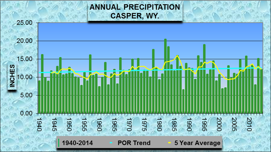
| 1 | 1982 | 20.48 | |||||
| 2 | 1995 | 18.94 | |||||
| 3 | 1983 | 18.41 | |||||
| 4 | 1978 | 17.64 | |||||
| 5 | 1941 | 16.24 | |||||
| 6 | 1957 | 16.12 | |||||
| 7 | 1986 | 15.92 | |||||
| 8 | 1993 | 15.91 | |||||
| 9 | 2009 | 15.77 | |||||
| 10 | 1947 | 15.40 | |||||
| 30 | 2014 | 12.13 | |||||
 |
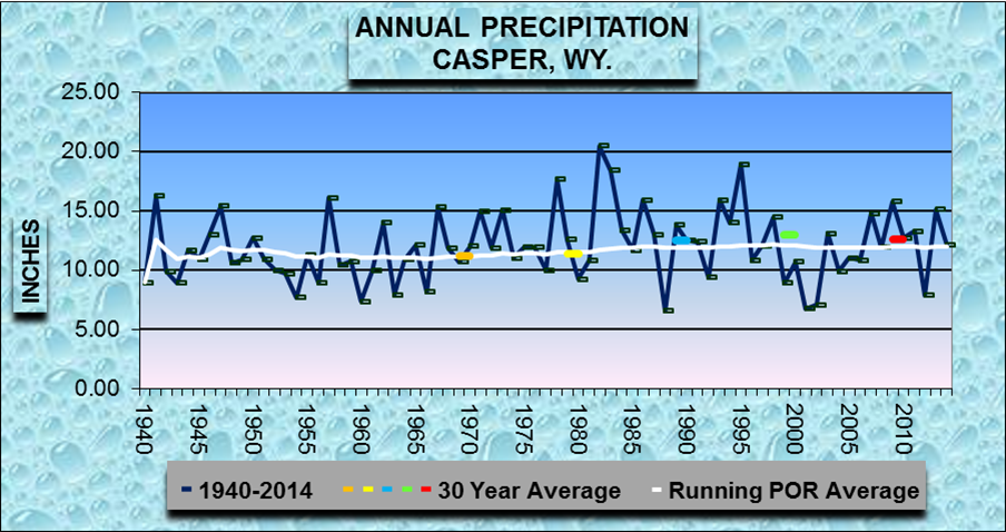 |
| Annual Precipitation for Period of Record - Click on Graph to Enlarge | |

| Element | Jan | Feb | Mar | Apr | May | Jun | Jul | Aug | Sep | Oct | Nov | Dec | Year |
| Total (inches) | 14.2 | 11.5 | 18.7 | 5.8 | 0.9 | 0.0 | 0.0 | 0.0 | 1.0 | 3.2 | 10.6 | 17.8 | 83.7 |
| Mean Snowfall (1981-2010 Normals) | 9.1 | 9.8 | 10.9 | 11.6 | 2.9 | 0.1 | 0.0 | 0.0 | 1.8 | 7.4 | 10.3 | 11.0 | 74.9 |
| Departure from Normal | 5.1 | 1.7 | 7.8 | -5.8 | -2.0 | -0.1 | 0.0 | 0.0 | -0.8 | -4.2 | 0.3 | 6.8 | 8.8 |
| Percent of Normal | 156 | 117 | 172 | 50 | 31 | 0 | 0 | 0 | 56 | 43 | 103 | 162 | 112 |
| Rank - Least Snowiest to Snowiest 75 Years (P.O.R 12/1939-2014) |
64 | 51 | 65 | 24 | 33 | NA | NA | NA | 58 | 26 | 48 | 72 | 54 |
| Greatest 24-HR Total | 4.0 | 3.6 | 3.0 | 3.1 | 0.9 | 0.0 | 0.0 | 0.0 | 1.0 | 2.1 | 4.3 | 5.0 | 5.0 |
| Dates of Occurrence | 14 | 25 | 1 | 13 | 11 | NA | NA | NA | 11 | 2 | 10 | 14 | 12/14 |
| Number of Days with: | |||||||||||||
| Snowfall >= 1.0 inch | 6 | 4 | 8 | 2 | 0 | 0 | 0 | 0 | 1 | 2 | 3 | 5 | 31 |
| Daily Snowfall Records Set or Tied | 0 | 0 | 0 | 0 | 0 | 0 | 0 | 0 | 0 | 0 | 0 | 1 | 1 |
Snowfall Ranks and Records:
One Day Snowfall Records (inches):
December: 5.0 on the 14th.
| Snowiest Months of December on Record | |||||||
| Rank | Year | Snowfall (inches) | |||||
| 1 | 1982 | 62.8 | |||||
| 2 | 1978 | 25.7 | |||||
| 3 | 1997 | 23.8 | |||||
| 4 | 2009 | 19.5 | |||||
| 5 | 2014, 1967 | 17.8 | |||||
| 7 | 1977 | 16.8 | |||||
| 8 | 1968 | 16.4 | |||||
| 9 | 2007, 1975 | 16.1 | |||||
| Top Ten Snowiest Years on Record | |||||||
| Rank | Year | Snowfall (inches) | |||||
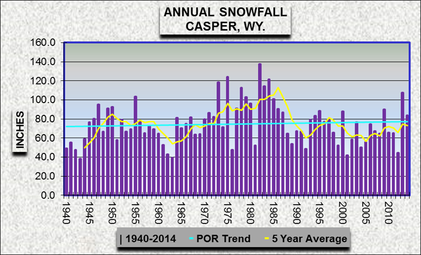
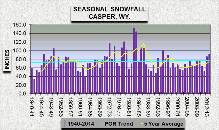
| 1 | 1982 | 137.6 | |||||
| 2 | 1975 | 124.0 | |||||
| 3 | 1984 | 121.2 | |||||
| 4 | 1973 | 118.3 | |||||
| 5 | 1983 | 114.2 | |||||
| 6 | 1978 | 112.7 | |||||
| 7 | 2013 | 107.5 | |||||
| 8 | 1955 | 103.3 | |||||
| 9 | 1979 | 103.0 | |||||
| 10 | 1985 | 101.0 | |||||
| 22 | 2014 | 83.7 | |||||
 |
 |
 |
|
| Annual and Seasonal Snowfall for Period of Record - Click on Graph to Enlarge | |
 |
Learn more about the National Weather Service's efforts to build a Weather-Ready Nation! |