Isolated heavy rainfall will continue through tonight across portions of central Texas, though some relief from the heavy rain is expected on Tuesday. Heat and humidity will remain in place across the Eastern U.S. and interior Northwest U.S. over the next few days with widespread moderate to major Heat Risk. Dangerous heat will build into the Desert Southwest Tuesday through Thursday. Read More >
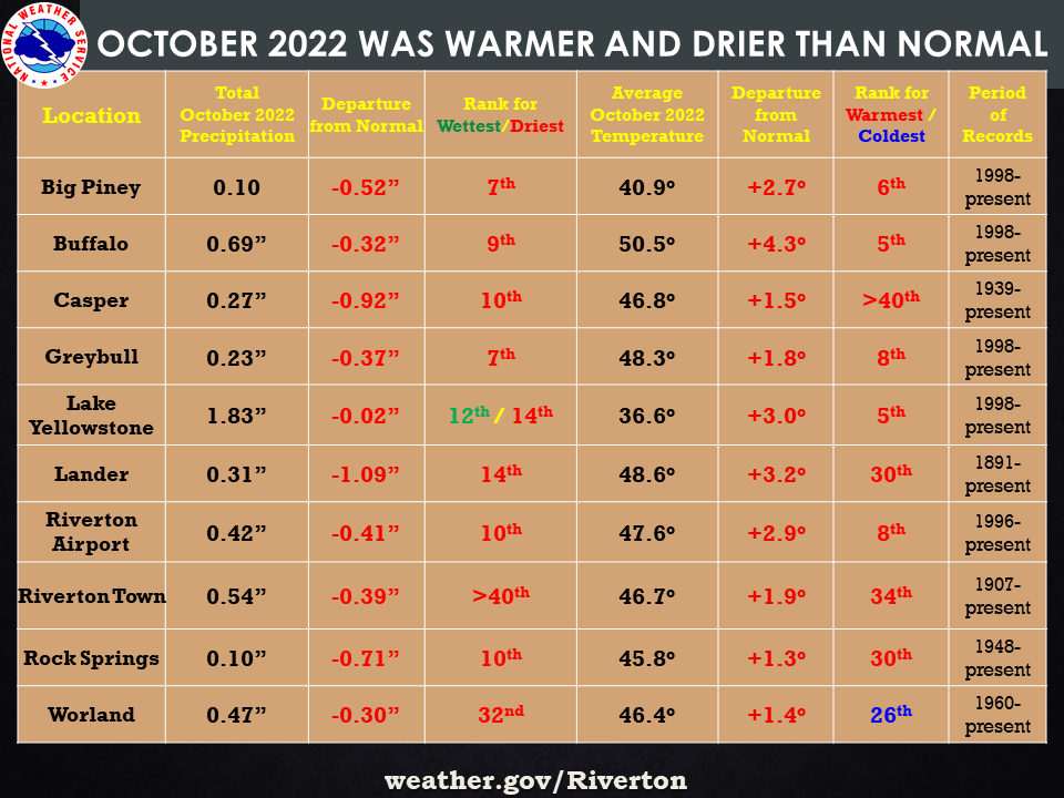
| The October 2022 climate summaries for Big Piney, Buffalo, Casper, Greybull, Lake Yellowstone, Lander, Riverton, Rock Springs, and Worland are now available online. |
 |
|
The month of October started off with a wet day on the 1st, but then turned dry for a bit. A major cold front passed through the state on the 22nd-23rd and dropped quite a bit of rain and areas of snow. There were a few daily rainfall records broken, namely Buffalo, Greybull, Riverton Airport, and Worland. Some of this liquid was actually melted snowfall. The front was also accompanied by quite a bit of wind as it passed through the region. Lander reported the highest gust of 70 mph on the 22nd, with 50 mph or more reported at Casper, Buffalo and Rock Springs. All of the climate sites received below normal precipitation for the month, with the exception of Lake Yellowstone which had 99% of normal. Temperatures for the month stayed near normal to above normal, with new daily record highs set at Riverton Airport and Buffalo on the 19th and 20th. Temperatures did drop with the cold front that moved through mid month, however they stayed fairly decent after this. Overnight lows did start to drop around the 25th and through the end of the month. The coldest days were the mainly the 27th and 28th. Check the CLMs for more specifics on daily records set at the various locations. See the links above for details for individual sites or click here for Water Year Precipitation summaries for more locations. If you would like additional, or more in-depth climate information, please refer to our Climate Page. From the Riverton Home Page, hover over the "Climate and Past Weather" tab, and select the "Local" option. Under the "Observed Weather" tab you can then find the Daily Climate Report (CLI), the Preliminary Monthly Climate Data (CF6), the Monthly Weather Summary (CLM), and the Regional Summary (RTP). The Daily Climate Report will have the weather data for the day (from midnight to 1159 pm). The Monthly Climate Data (CF6) will have this data for each day of the month, compiling all the daily data into one form. The Regional Summary will have temperature and precipitation data for various locations across the state, updated 3 times a day. |
|