
High winds and very dry conditions will bring extremely critical fire weather over a large part of New Mexico today. Red Flag and High Wind Warnings have been issued. Isolated to scattered severe thunderstorms may produce large to very large hail and localized damaging winds late this afternoon into evening from the eastern Central Plains to the Upper Midwest. Read More >
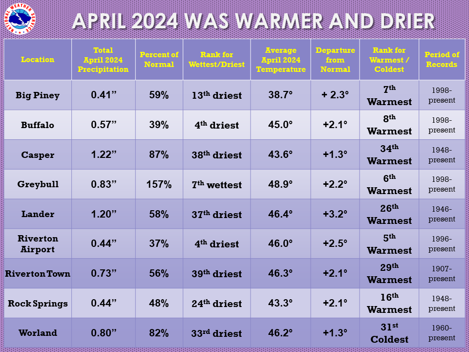
| The April 2024 climate summaries for Big Piney, Buffalo, Casper, Greybull, Lake Yellowstone, Lander, Riverton, Rock Springs, and Worland are now available online. |
 |
|
The month of April was warmer and drier than normal. April Fool’s Day started off with snow showers and colder temperatures. But then the first week of the month warmed up quite nicely. Easter weekend had a front move through the state with snow in the mountains and rain and snow in the valleys. This cooled the temperatures by almost 30 degrees from the first week. High pressure finally built back in after the 10th for another warmup and drier weather. The 16th and 17th saw another cold front push through the state and dropped the temperatures again. There was snow and rain/snow mix across the area. The heaviest snow fell in the Big Horn area. There were gusty winds across the state with Big Piney and Buffalo seeing 40 to 50 mph. The coldest days of the month were the 18th-20th with Lake Yellowstone dropping to -6 on the 18th. Another system on the 21st-22nd brought in strong winds along with very dry air and elevated fire weather concerns, mainly across Sweetwater County. There was a very wet system that moved through the 26th to 29th with some areas getting decent rainfall amounts. Snow fell in the mountains with 12 to 14 inches in the Wind River Range. There were a few daily temperature and precipitation records broken during the month. Check the CLMs for more specifics on daily records set at the various locations. See the links above for details for individual sites or click here for Water Year Precipitation summaries for more locations. If you would like additional, or more in-depth climate information, please refer to our Climate Page. From the Riverton Home Page, hover over the "Climate and Past Weather" tab, and select the "Local" option. Under the "Observed Weather" tab you can then find the Daily Climate Report (CLI), the Preliminary Monthly Climate Data (CF6), the Monthly Weather Summary (CLM), and the Regional Summary (RTP). The Daily Climate Report will have the weather data for the day (from midnight to 1159 pm). The Monthly Climate Data (CF6) will have this data for each day of the month, compiling all the daily data into one form. The Regional Summary will have temperature and precipitation data for various locations across the state, updated 3 times a day. |
|

