A powerful spring storm continues across the country with multiple high impacts in the forecast. Life-threatening, catastrophic, and potentially historic flash flood event continues across the Lower Ohio Valley and Mid-South. A couple rounds of significant severe weather expected from the Mid-South through the Ozarks and ArkLaTex with very large hail and strong tornadoes possible. Read More >
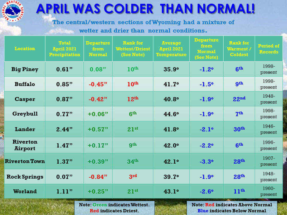
| The April 2021 climate summaries for Big Piney, Buffalo, Casper, Greybull, Lake Yellowstone, Lander, Riverton, Rock Springs, and Worland are now available online. |
 |
|
April started off with a few record high temperatures the first few days. It then turned out to be a fairly breezy month, with winds staying quite strong much of the time. There was quite a wind storm on the 8th, with max speeds 55 to 70 mph across the state. The 10th also saw some pretty strong winds. Weather was active as well in April. A front on the 5th and 6th brought a decent rainfall for most locations. A snow storm on the 14-16th covered the entire state with at least an inch of snow. However, Lander, Riverton and Thermopolis receiving quite a bit of snow (8 – 14 inches) due to upslope flow. Luckily this storm had lots of liquid in it, even if it was in the form of snow. The snow melted fairly quickly. Another snowstorm hit on the 18-19th bringing more snow, but only a trace to around 5 inches. Johnson County took the brunt of that storm. The storm brought the seasonal total snowfall for Casper to 100.3 inches. This storm also brought a few record low temperatures. There was a good snow for western Wyoming on the 25-26th, with 2 to 3 inches falling in the valleys to 8 -13 inches at the mountain tops. This storm also brought some strong winds with it. One thing of note for the month is that Rock Springs was left out of the good moisture, with its 3rd driest April on record. Even Casper was on the drier side in April. The month did end with a few hot days, with record breaking temperatures at nearly all of the climate sites on the 30th. Casper even had a tie for the all-time warmest day of the month, hitting 84 degrees, last seen in 1992. Check the CLMs for more specifics on daily records set at the various locations. See the links above for details for individual sites or click here for Water Year Precipitation summaries for more locations. If you would like additional, or more in-depth climate information, please refer to our Climate Page. From the Riverton Home Page, hover over the "Climate and Past Weather" tab, and select the "Local" option. You can then find the Daily Climate Report (CLI), the Preliminary Monthly Climate Data (CF6), the Monthly Weather Summary (CLM), and the Regional Summary (RTP). The Daily Climate Report will have the weather data for the day (from midnight to 1159 pm). The Monthly Climate Data (CF6) will have this data for each day of the month, compiling all the daily data into one form. The Regional Summary will have temperature and precipitation data for various locations across the state, updated 3 times a day. |
|