National Weather Service United States Department of Commerce

Severe Thunderstorms and Heavy Rain in the Southern Plains; Fire Weather Threat in the Southwest U.S.

Thunderstorms, some severe, may produce heavy to excessive rainfall and isolated flooding over portions of the Southern Plains today and Saturday. Dry conditions, combined with gusty winds and low relative humidities will continue to support an elevated to critical fire weather threat in the Desert Southwest into to early next week. Read More >

Yellowstone National Park Destination Banner
Watch/Warnings/Advisories Riverton Radar Loop Pocatello, ID Radar Loop
Western & Central Wyoming Hazard Map Radar out of Riverton, WY Radar out of Pocatello, ID
Severe Weather Outlook Weather Story Northern Rockies Radar
Weather Story Northern Rockies Radar Loop

Lightning Potential Forecasts (Updated Hourly)
Hour 1-3
Hour 4-6
Hour 7-9
 
Hour 9-11
Hour 11-13
Hour 15-17
 
Hour 17-19
Hour 19-21
Hour 21-23
 

Return to Top

Text Banner

Frequently Requested Text Products
Area Forecast
Discussion
Hazardous
Weather Outlook
Public Info
Statement
Situation Report
(issued for high-impact events)
Winter Wx
Statement
Lake Yellowstone
Daily Climate
Local Hourly
Weather
WY Hourly
Weather
Regional 24-hr
Temp & Precip Summary
Local Storm
Reports


Return to Top

Forecast Graphic Banner

24 Hour Snow Accumulation
48 Hour Snow Accumulation
72 Hour Snow Accumulation
24-hour Snow Accumulation
48-hour Snow Accumulation
72-hour Snow Accumulation
24 Hour Liquid Precipitation
48 Hour Liquid Accumulation
72 Hour Liquid Accumulation
24-hour Liquid Precipitation
48-hour Liquid Precipitation
72-hour Liquid Precipitation
Today's High
Tomorrow's High
Day 3 High Temperature
Today's High
Tomorrow's High
Day 3 High
Today's Low
Tomorrow Night's Low
Day 3 Low Temperature
Today's Low
Tomorrow's night low
Day 3 night's low


Return to Top

River Stages Banner

River Gauge Stages (Hydrographs) - Click on Graphs to Enlarge
Yellowstone River at Fishing Bridge
(Current Stage)
Gibbon River at Madison Junction
(Current Stage)
Yellowstone River at Fishing Bridge
Gibbon River at Madison Junction
Madison River near West Yellowstone
(Current Stage)
Gardner River near Mammoth
(Current Stage)
Madison River near West Yellowstone
Gardner River near Mammoth
Lamar River near Tower Falls
(Current Stage)
Soda Butte Creek near Silver Gate
(Current Stage)
Lamar River near Tower Falls
Soda Butte Creek near Silver Gate
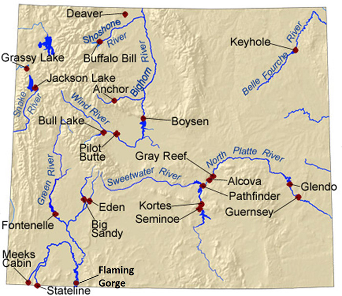
Wyoming Reservoir Levels (click on the red dots)

More Information on River Stages across Wyoming


Return to Top

SnoTel Banner

SnoTel Data - Click to Enlarge
Snow Water Equivalent % of Normal
Snow Water Equivalent % of Median (~normal)
 
Yellowstone National Park SnoTels impacting basins - Click on them for more data
 
SnoTels impacting the Yellowstone water drainages
SnoTels and River Gauges by River Basin across Western & Central Wyoming found here

Return to Top

Fire Weather Banner

Day 1 Fire Weather Outlook Day 2 Fire Weather Outlook Day 3 Fire Weather Outlook
Fire Weather Day 1 Outlook
Fire Weather Day 2 Outlook
Fire Weather Day 3 to 8 Outlook
Day 1 Max Temp
Minimum RH Day 1
Wind Gusts over the next few hours
Wind Gusts over the next 12 hours
Day 2 High Temperature
Day 2 Min RH
Peak Wind 24-36 hours Peak Wind 36-48 hours
More Fire Weather Information Here

Return to Top

Drought Information Statement


Wyoming Drought Monitor Seasonal Drought Outlook
Wyoming Drought Monitor U.S. Seasonal Drought Outlook

 Category 

 Description 

Possible Impacts

D0

Abnormally
Dry

Going into drought: short-term dryness slowing planting, growth of crops or  pastures. Coming out of drought: some lingering water deficits;  pastures or crops not fully recovered

D1

Moderate
Drought

Some damage to crops, pastures; streams, reservoirs, or wells low, some water shortages developing or imminent; voluntary water-use restrictions requested

D2

Severe
Drought

Crop or pasture losses likely;  water shortages common; water restrictions imposed

D3

Extreme
Drought

Major crop/pasture losses;  widespread water shortages or restrictions

D4

Exceptional
Drought

Exceptional and widespread crop/pasture losses; shortages of water in reservoirs, streams, and wells creating water emergencies

6 to 10 Day
Temperature Outlook
6 to 10 Day
Precipitation Outlook
One and Three Month
Temp & Precip Outlook
6 to 10 day temperature outlook 6 to 10 day precipitation outlook 1 to 3 month precipitation and temperature outlook


Return to Top

Yellowstone National Park Logo
WYDOT logo
CODOT logo IDDOT logo
MTDOT logo NEDOT logo
SDDOT logo UTDOT logo


Return to Top

Banner - Destination Forcasts

Click on selected popular destinations below to get a detailed forecast
Map of Yellowstone National ParkN. Entrance YNPMammoth West Entrance Madison Norris Tower-Roosevelt NE Entrance Mount Washburn Canyon Fishing Bridge East Entrance of Yellowstone Lake Village Bridge Bay West Thumb Grant Village Lewis Lake South Entrance of Yellowstone Old Faithful

Return to Top