
Anomalously warm, dry and breezy conditions will bring elevated to critical fire weather conditions across portions of the Intermountain West into the Plains though early this week. Another elevated risk is possible across the central Appalachians. A rapid warm-up is in the forecast beginning Monday across the central and eastern U.S.. Read More >
 |
Building a Weather-Ready Nation |
Summary | Forecast | Monitoring & Reporting | Safety
The incident management team involved in the Bighorn/Washakie County floods has been working nonstop to prep towns along the Nowood and Bighorn rivers for additional ice jam and runoff flooding. Their efforts have paid off as ice jams clear, waters recede, and sand bags are stockpiled for spring runoff.
The snow and cold temperatures should slow the movement of existing ice jams and prevent any runoff from entering the picture today. Overall, the flooding materialized mainly due to river break up causing ice jams, at least in the Bighorn basin. Ice jams on the Big Horn River and Upper Nowood are beginning to release and channels are being opened up, decreasing if not ending the ice jam flood threat. Most of the flooded areas are in clean up mode. Snow melt runoff at Medicine Lodge State Archaeological Site near Hyattville has temporarily closed that site until further notice.
The Bighorn Basin
Thanks to the efforts of the incident management team, there was no major flooding in the town of Greybull. The levee system was tested north of town Sunday afternoon as a jam raised the water levels to within about 3 feet of the top of the levee. Now that the waters have receded, it is clear that the levee passed with flying colors. There was some water that went into areas north of town around dry creek this weekend, this area was outside of the levee system. There were 7 homes outside of the levee system that were evacuated and experienced some minor flooding. The town of Greybull and the Red Cross are working with these residents to asses the damage and get them back into their homes.
There was high water approaching the lagoon early in the event, this water has since receded and the infrastructure is well protected, but not after some damage was done to the lift system. This system is now being manned 24/7 and manually operated until the electrical systems can be reparied. The infrastructure around the town is now well prepared for the spring runoff, which is expected to be well above normal.
So far, the town of Worland was hit the hardest with significant flooding of neighborhoods and businesses experienced Friday around the Highway 789 bridge along the railroad tracks. Preliminary estimates suggest that there were 4 homes heavily damaged, 9 residences sustained minor damage, and no homes were "destroyed." The Red Cross has a response vehicle in Worland supplying food and cleanup kits. The ice jam moved on from Worland on Sunday and the waters receded shortly thereafter, but some large chunks of ice remained. The Red Cross is still working on securing donations for long term recovery needs around Worland.
 |
|
Click Image To Enlarge The Wyoming National Guard has four Rapid Action Teams (RAT) around northern Wyoming assisting with the flood preparation efforts. Photo: Wyoming National Guard |
This ice jam was on the move down the Bighorn River on Monday and it joined with the existing ice jam overnight above Manderson. There was a brief water rise after the jams joined but the water is flowing freely beneath the ice jam. There was no additional flooding and it is believed that the threat has passed! A business was flooded Saturday night and there were three residences surrounded by water. The Wyoming National Guard is assisting those residents and the bean mill with sandbagging efforts. Water was flowing down main street Saturday night, this water has been redirected into the storm drain system and is no longer at nuisance levels. A Rapid Action Team was at the Manderson Elementary School on Monday to reenforce the protection surrounding the school in anticipation of the additional ice and water coming with the jam. A semi-truck load of sandbags was placed in the town on Monday to provide further reenforcements to flood protection around the town in anticipaton of an above normal spring runoff.
The Nowood was flowing freely and was sending water downstream as of Sunday, however there was a landslide into the Nowood on Monday, which again raised concern that the river may again back up and flood the surrounding area. The slide occurred just upstream of an existing ice jam and it is only covering part of the old river channel, the river was able to cut a new path around the slide with no further issues.
 |
|
Click Image To Enlarge Ice jam near TenSleep. Photo courtesy of Bob Montgomery |
There was a jam near Ten Sleep Saturday afternoon, which led to evacuation of 2 ranches. As of Sunday morning, there was still a 3 mile long ice jam along the Lower Nowood near TenSleep; impact assessments have determined that there is little in the way of critical infrastructure or any population centers at risk from this particular jam, all ranches along this section of the Upper Nowood have been contacted. The Washakie/Bighorn County Public Health Response Coordinator was in Ten Sleep over the weekend helping with the well testing as there is a boil water order for residents affected by the flood water. Public Health is also providing tips on safe flood cleanup (see the bottom of this page for more tips from the Health Department).
As of Tuesday morning, it looks like the main channels are free of ice and the ice jam threat has waned, but a significant amount of snow remains in the Bighorn Mountains - very little of this water has run off and the snow pack is still well above normal. These same areas could see high water in the coming weeks if there is a sudden extreme warm up, so stay alert this spring in these areas, even if the ice jam threat has passed.
For those areas that do still have ice covered rivers: we had a cold winter that led to the production of some thick ice. When this ice eventually breaks up, it increases the chance of more ice jams this spring. Remain aware and be sure to report ice breakup to our office and to your local sherriff's office so that we can try to get ahead of the flooding.
Across the West
Mild temperatures last week caused snow to melt across the western valleys as temperatures warmed each afternoon. This led to ponding in localized low spots. Eventually the melt water goes on the move and tries to find a place to settle since it cannot absorb into the frozen ground, often this spot is a basement, driveway, road, or crawlspace. This activity has slowed over the past couple of days.
Areas impacted include: Auburn, Afton, Thayne, and Jackson. (Click Here For Teton County Situation Report)
 |
 |
|
Click Image To Enlarge Observed snow melt Sunday-Monday |
Click Image To Enlarge Ripe (ready to melt) Snow Pack as of Monday Morning |
MEDIA COVERAGE:
|
|
|
|
|
|
|
|
|
 |
 |
 |
 |
|
|
|
|
|
 |
 |
 |
 |
| Photo Credit: Brandon Yule |
|
|
|
 |
 |
 |
 |
| N Greybull - Katie Warriner |
|
|
|
 |
 |
 |
 |
| S Greybull - K. Warriner |
|
|
|
 |
 |
 |
 |
| Worland After - J. McCartney |
|
|
|
 |
 |
 |
 |
| Greybull - Paul Hesco |
|
|
|
 |
 |
 |
 |
|
|
|
|
|
|
|
|
|
Worland Hourly WX Graph |
|
|
|
Temperatures will be lower today behind the cold front with periods of light to moderate snow through the morning. There will be rapid clearing from north to south this afternoon with some sun poking out before sunset. It will be warmer for the rest of the week, but not as warm as the weekend. Hopefully, the ice jams have been cleared and we can focus on spring runoff. In order to get the snow in the mountains to melt, you need several days of highs in the 70s in the basins and you need temperatures to remain above freezing overnight. A significant high elevation rain event would also get the runoff to come off suddenly. Otherwise, we need to hope for a nice, mild warm period with freezing temperatures at night to help the water come down at a pace that can be handled by the rivers. The snow pack is very healthy this year and we haven't even had our big spring snow season yet. Some of the basin snow pack levels exceed what we had back in 2011.
If you live in a flood prone area, near a bridge crossing the river, or near a sharp bend in a river you should prepare for possible flooding this spring.
 |
 |
|
Click Image To Enlarge Today's High Temperature Forecast |
Click Image To Enlarge |
 |
 |
|
Click Image To Enlarge Wednesday High Temperature Forecast |
Click Image To Enlarge Thursday High Temperature Forecast |
 |
 |
|
Click Image To Enlarge Friday High Temperature Forecast |
Click Image To Enlarge Saturday High Temperature Forecast |
Please continue to call/send us your photos, and don't forget to monitor our Facebook page and Twitter feed for the latest on the flooding.
 |
 |
|
Click Image To Enlarge The Bighorn Basin Snow Water Equivalent (SWE) or the Amount of Water Still Contained in the Snow Pack that has yet to enter the river. Observed (red line) with forecast (multi-colored lines) The median SWE amount is represented by the black line going through the gray shaded area. |
Click Image To Enlarge The Snake River Basin (Relevant to Jackson and Star Valleys) Snow Water Equivalent (SWE) or the Amount of Water Still Contained in the Snow Pack that has yet to enter the river. Observed (red line) with forecast (multi-colored lines) The median SWE amount is represented by the black line going through the gray shaded area. |
 |
 |
|
Click Image To Enlarge The Upper Bear River (Relevant to Southern Lincoln County) Snow Water Equivalent (SWE) or the Amount of Water Still Contained in the Snow Pack that has yet to enter the river. Observed (red line) with forecast (multi-colored lines) The median SWE amount is represented by the black line going through the gray shaded area. |
Click Image To Enlarge The Upper Green River Basin Snow Water Equivalent (SWE) or the Amount of Water Still Contained in the Snow Pack that has yet to enter the river. Observed (red line) with forecast (multi-colored lines) The median SWE amount is represented by the black line going through the gray shaded area. |
 |
 |
|
Click Image To Enlarge
Snow Water Equivalent (SWE) Percent of Median
|
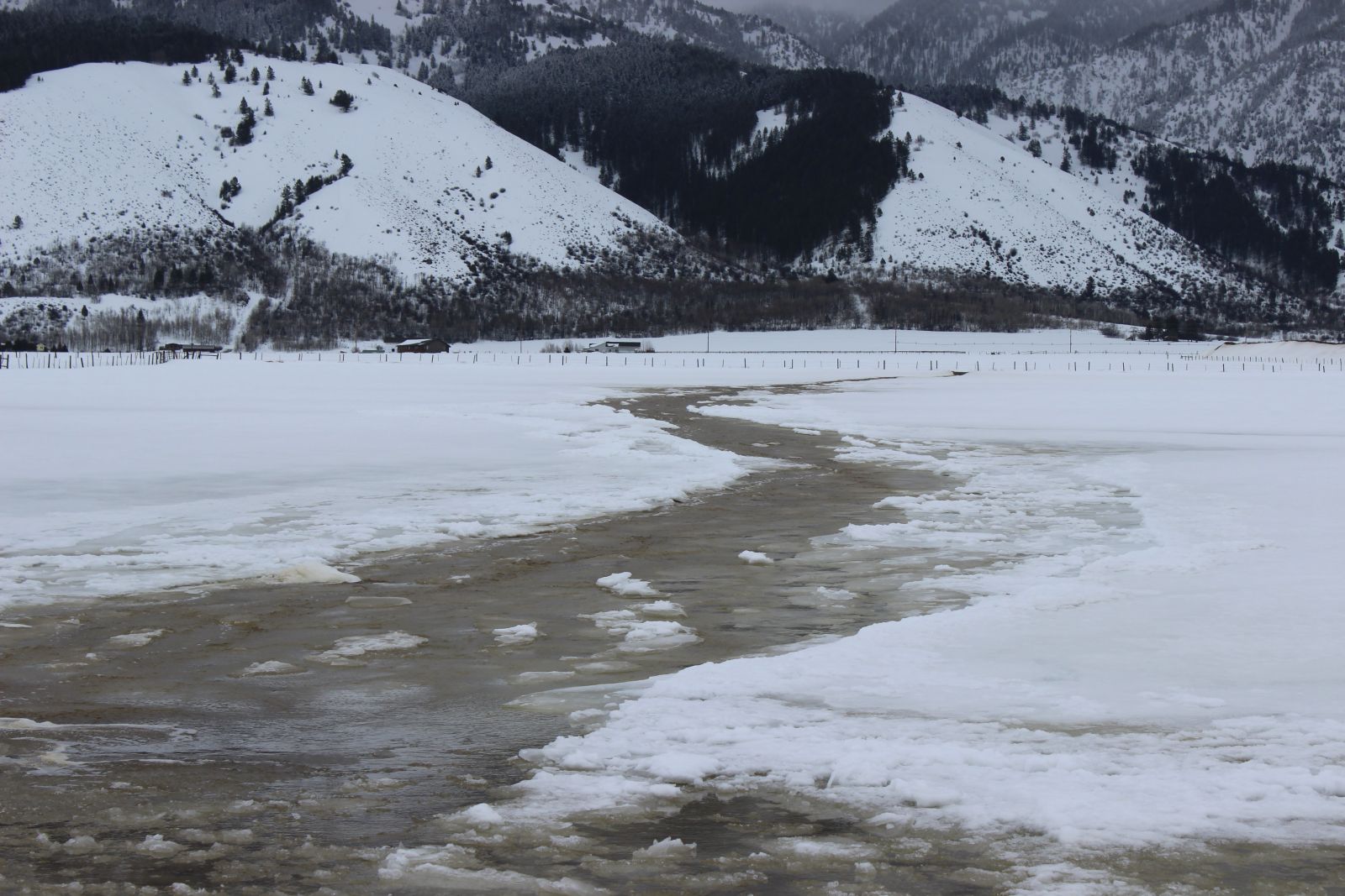
Click Image To Enlarge Nowood River Near Manderson |
 |
Monitor our Severe Weather Summary Page for current Warnings, Watches, and Advisories. What's the difference? |
 |
Check the latest Weather Story graphic for an overview of the area forecast. |
 |
Check out what's on the radar. Riverton | Pocatello | Cheyenne | Billings | Salt Lake City | Rapid City | Mosaic |
| Submit storm reports/images and keep up to date with us on Facebook! | |
 |
Submit storm reports/images and keep up to date with us on Twitter! |
 |
Other reporting methods include eSpotter, email (cr.wxriw@noaa.gov), or by phone at 1-800-211-1448. |
 |
Check the latest Public Information Statement for the latest storm reports. |
| Monitor current road conditions by visiting the Wyoming Dept. of Transportation (WYDOT) or by calling 5-1-1. |
| Here's some informative tips from the Washakie County Sheriff's Office and Worland Police Department about reentering a home that has been flooded. Saturday March 8th, 2014 1:00 p.m. Emergency Personnel have been working closely with Public Health Response Coordinator Kami Neighbors, who has provided us information in regards to post flood and contamination concerns. I will attach that information to this post. It is very important that if anyone is currently using a well for consumption use (in the flood areas), they must first have their water tested. Please contact Kami Neighbors for testing at (307)431-2446 or at Public Health Office at (307)347-3278. Reentering Your Flooded Home When returning to a home that’s been flooded, be aware that your house may be contaminated with mold or sewage, which can cause health risks for your family. When You First Reenter Your Home • If you have standing water in your home and can turn off the main power from a dry location, then go ahead and turn off the power, even if it delays cleaning. If you must enter standing water to access the main power switch, then call an electrician to turn it off. NEVER turn power on or off yourself or use an electric tool or appliance while standing in water. • Have an electrician check the house’s electrical system before turning the power on again. Dry Out Your House If flood or storm water has entered your home, dry it out as soon as possible. Follow these steps: • If you have electricity and an electrician has determined that it’s safe to turn it on, use a “wet-dry” shop vacuum (or the vacuum function of a carpet steam cleaner), an electric-powered water transfer pump, or sump pump to remove standing water. If you are operating equipment in wet areas, be sure to wear rubber boots. • If you do not have electricity, or it is not safe to turn it on, you can use a portable generator to power equipment to remove standing water. Note: If you must use a gasoline-powered pump, generator, pressure washer, or any other gasoline-powered tools to clean your home, never operate the gasoline engine inside a home, basement, garage, carport, porch, or other enclosed or partially enclosed structures, even if the windows and doors are open. Such improper use can create dangerously high levels of carbon monoxide and cause carbon monoxide poisoning. • If weather permits, open windows and doors of the house to aid in the drying-out process. • Use fans and dehumidifiers to remove excess moisture. Fans should be placed at a window or door to blow the air outwards rather than inwards, so not to spread the mold. • Have your home heating, ventilating, and air-conditioning (HVAC) system checked and cleaned by a maintenance or service professional who is experienced in mold clean-up before you turn it on. If the HVAC system was flooded with water, turning on the mold-contaminated HVAC will spread mold throughout the house. Professional cleaning will kill the mold and prevent later mold growth. When the service determines that your system is clean and if it is safe to do so, you can turn it on and use it to help remove excess moisture from your home. • Ensure that crawl spaces in basements have proper drainage to limit water seepage. Ventilate to allow the area to dry out. Inside the Home • Keep children and pets out of the affected area until cleanup has been completed. • Wear rubber boots, rubber gloves, and goggles during cleanup of affected area. • Remove and discard items that cannot be washed and disinfected (such as, mattresses, carpeting, carpet padding, rugs, upholstered furniture, cosmetics, stuffed animals, baby toys, pillows, foam-rubber items, books, wall coverings, and most paper products). • Remove and discard drywall and insulation that has been contaminated with sewage or flood waters. • Thoroughly clean all hard surfaces (such as flooring, concrete, molding, wood and metal furniture, countertops, appliances, sinks, and other plumbing fixtures) with hot water and laundry or dish detergent. • Help the drying process by using fans, air conditioning units, and dehumidifiers. • After completing the cleanup, wash your hands with soap and warm water. Use water that has been boiled for 3 minutes (allow the water to cool before washing your hands). o Or you may use water that has been disinfected for personal hygiene use (solution of â�� teaspoon [~0.75 milliliters] of household bleach per 1 gallon of water). Let it stand for 30 minutes. If the water is cloudy, use a solution of ¼ teaspoon (~1.5 milliliters) of household bleach per 1 gallon of water. • Wash all clothes worn during the cleanup in hot water and detergent. These clothes should be washed separately from uncontaminated clothes and linens. • Seek immediate medical attention if you become injured or ill. Gabe R. Elliott Worland Police Department |
|
Learn more about the National Weather Service's efforts to build a Weather-Ready Nation! |


