National Weather Service United States Department of Commerce

Snow Across the Great Lakes, Central Appalachians, and Northeast; Unsettled Weather in the West

Light to moderate snow will continue into Saturday over the Great Lakes, Central Appalachians, and Northeast. This weekend into next week, a series of atmospheric rivers will bring gusty winds, periods of heavy rain, and mountain snow to northern California and the Pacific Northwest. Colder temperatures are in store for the weekend from the Great Lakes to East Coast. Read More >

Upper Yellowstone Basin
SnoTel Graphs (Click on Images to Enlarge)
Thumb Divide 2019 Compared to Highest Years
Canyon 2019 Compared to Highest Years
Sylvan Lake 2019 Compared to Highest Years
Sylvan Road 2019 Compared to Highest Years
Parker Peak 2019 Compared to Highest Years
▼▼▼▼▼▼                                                                                                  ▼▼▼▼▼▼▼
Upper Yellowstone / Madison RIver Basin  River Basin Hydrographs
(Click on Images to Enlarge)
Yellowstone River at Fishing Bridge
Record Crest 8.90 ft. on 6/18/1997
Crest of 8.74 ft on 7/11/2011
Lamar River near Tower Falls
Record Crest 12.15 ft on 6/10/1996
Crest of 11.50 ft on 6/5/2010
Gardner River near Mammoth
Record Crest of 5.09 ft. on 6/5/2010
Soda Butte Creek near Silver Gate
Record Crest of 3.85 ft on 6/30/2011
Gibbon River at Madison Junction
Record Crest of 6.43 ft. on 6/8/2011


Shoshone and Clarks Fork River Basins
Shoshone
 Clarks Fork
Shoshone River Basin
SnoTel Graphs (Click on Images to Enlarge)
Younts Peak 2019 Compared to Highest Years
Marquette 2019 Compared to Highest Years
Blackwater 2019 Compared to Highest Years
Sylvan Lake 2019 Compared to Highest Years
Sylvan Road 2019 Compared to Highest Years
Evening Star 2019 Compared to Highest Years
▼▼▼▼▼▼                                                                                                  ▼▼▼▼▼▼▼
Shoshone River Hydrographs (Click on Images to Enlarge)
South Fork of Shoshone River near Valley
Record Crest 9.24 ft. on 6/9/1981
Crest of 8.80 ft. on 6/9/2016
South Fork of Shoshone River above Buffalo Bill Reservoir
Record Crest 9.41 ft on 6/9/1981
Crest of 9.28 ft on 6/30/2011
North Fork of Shoshone River at Wapiti
Record Crest of 12.00 ft. on 6/9/1981
Shoshone River near Lovell
Record Crest of 11.27 ft on 6/13/2001
Shoshone and Clarks Fork River Basins
Shoshone
Clarks Fork
Clarks Fork of the Yellowstone River Basin
SnoTel Graphs  (Click on Images to Enlarge)
Parker Peak 2019 Compared to Highest Years
Evening Star 2019 Compared to Highest Years
Wolverine 2019 Compared to Highest Years
Beartooth Lake 2019 Compared to Highest Years
▼▼▼▼▼▼                                                                                                  ▼▼▼▼▼▼▼
Clarks Fork of the Yellowstone River Hydrograph (Click on Images to Enlarge)
Clark's Fork of the Yellowstone River near Belfry, MT
Record Crest 9.97 ft on 6/9/1981


Snake and Salt River Basins
Snake River Basin
Salt River Basin
SnoTel Graphs (Click on Images to Enlarge)
Lewis Lake Divide 2019 Compared to Highest Years
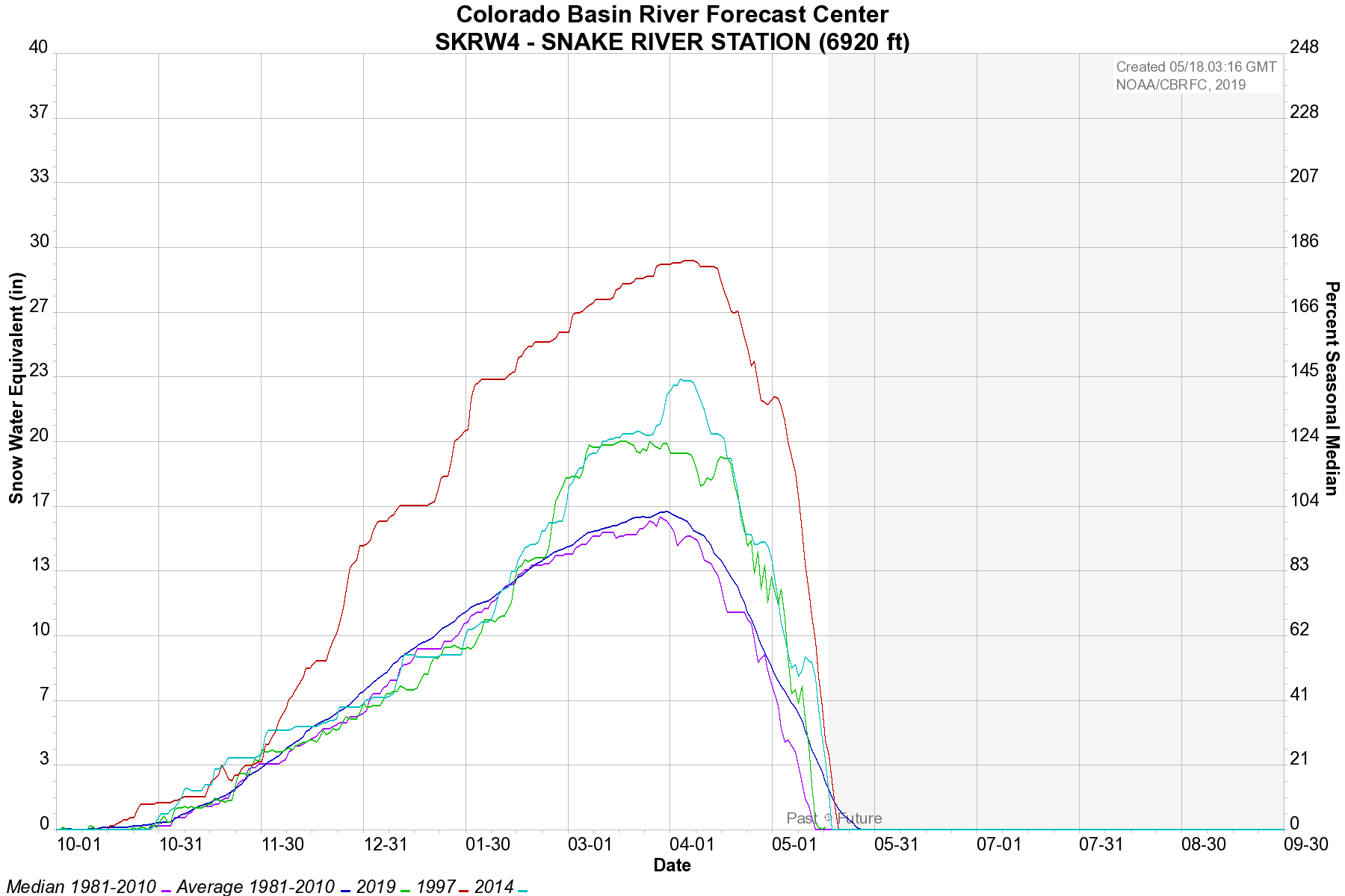
Snake River Station 2019 Compared to Highest Years
Grassy Lake 2019 Compared to Highest Years
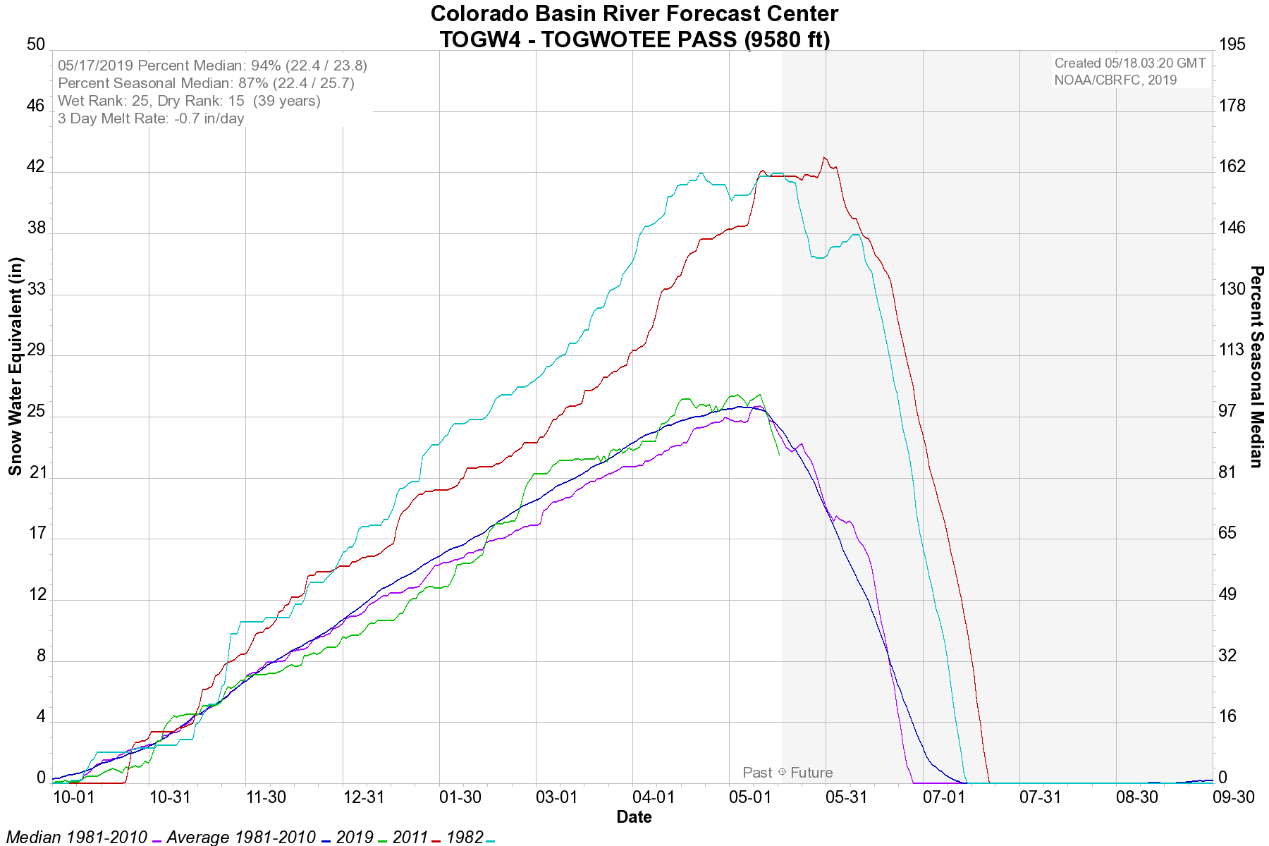
Togwotee Pass 2019 Compared to Highest Years
Grand Targhee 2011
Phillips Bench 2019 Compared to Highest Years
Gros Ventre Summit 2019 Compared to Highest Years
Granite Creek 2019 Compared to Highest Years
▼▼▼▼▼▼                                                                                                  ▼▼▼▼▼▼▼
Snake River Basin Hydrographs
(Click on Images to Enlarge)
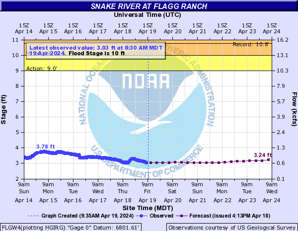
Snake River at Flagg Ranch
Record Crest 10.75 ft. on 6/5/1996
Crest of 9.25 ft. on 6/24/2011
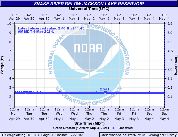
Snake River below Jackson Dam
Record Crest 11.63 ft on 6/19/1943
Crest of 10.67 ft on 6/12/2010
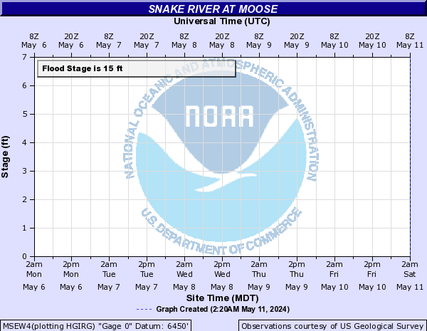
Snake River at Moose
Record Crest of 15.25 ft. on 6/11/1997
Crest of 14.61 ft. on 6/8/2010
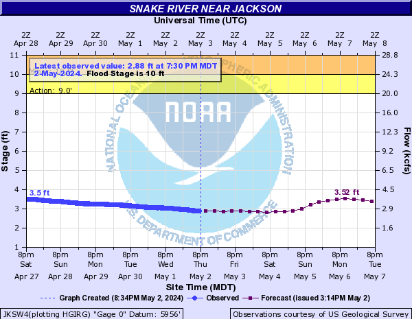
Snake River near Jackson
Record Crest of 11.66 ft. on 6/11/1997
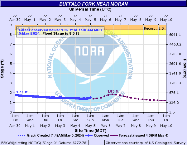
Buffalo Fork near Moran
Record Crest of 8.50 ft.on 6/9/1981
Crest of 8.18 ft. on 7/1/2011
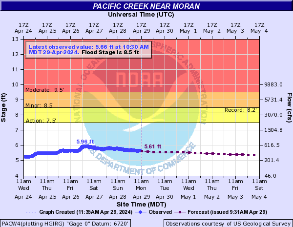
Pacific Creek near Moran
Record Crest of 7.99 ft on 5/29/2014 and 5/21/2008
Snake and Salt River Basins
Snake River Basin
Salt River Basin
SnoTel Graphs (Click on Images to Enlarge)
Salt River Summit 2019 Compared to Highest Years
Cottonwood Creek / Lake 2019 Compared to Highest Years
Willow Creek 2019 Compared to Highest Years
Blind Bull Summit 2019 Compared to Highest Years
▼▼▼▼▼▼                                                                                                  ▼▼▼▼▼▼▼
Salt River Basin Hydrographs
(Click on Images to Enlarge)
Salt River near Etna
Record Crest 5.99 ft. on 5/25/2011
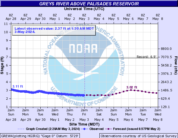
Greys River near Alpine
Record Crest 6.88 ft on 6/13/1965
Crest of 5.29 ft on 6/5/2010
Snake River near Alpine
Record Crest of 14.04 ft. on 6/11/1997
Crest of 11.30 ft. on 7/1/2011


Upper Bear River Basin
SnoTel Graphs (Click on Images to Enlarge)
Kelly Ranger Station 2019 Compared to Highest Years
Salt River Summit 2019 Compared to Highest Years
▼▼▼▼▼▼                                                                                                  ▼▼▼▼▼▼▼
Upper Bear River Basin Hydrographs
(Click on Images to Enlarge)
Bear River below Pixley Dam
Record Crest 10.90 ft. on 6/5/1983
Crest of 9.72 ft. on 6/19/2011
Bear River near Cokeville
Record Crest 8,75 ft. on 6/7/1983
Crest of 7.90 ft on 6/27/2011
Bear River at Border, ID
Record Crest of 9.67 ft. on 6/7/1983
Crest of 9.38 ft. on 6/27/2011
Smiths Fork near Border, WY
Record Crest of 5.66 ft. on 6/4/1986
Crest of 3.66 ft. on 6/25/2011


Green River Basin
SnoTel Graphs - West Slopes of the Wind River Mountains
(click on images to enlarge)
Kendall R.S. 2019 Compared to Highest Years
New Fork Lake 2019 Compared to Highest Year
Elkhart Park G.S. 2019 Compared to Highest Years
Gunsight Pass 2019 Compared to 2011
Big Sandy Opening 2019 Compared to 2011 and Highest Year
SnoTel Graphs - Gros Ventre and Wyoming Ranges
(click on images to enlarge)
Loomis Park 2019 Compared to Highest Years
East Rim Divide 2019 Compared to Highest Year
Blind Bull Summit 2019 Compared to Highest Years
Triple Peaks 2019 Compared to Highest Years
Spring Creek Divide 2019 Compared to Highest Years
Snider Basin 2019 Compared to Highest Years
▼▼▼▼▼▼                                                                                                  ▼▼▼▼▼▼▼
Green River Hydrographs
Green River at Warren Bridge
Record Crest 6.04 ft on 6/11/1997
Green River Near La Barge
Record Crest 10.5 ft on 6/9/1986
Green River below Fontenelle Dam
Record Crest 18.74 ft on 9/5/1965
Green River at Green River
Record Crest 8.53 ft on 9/7/1965
Blacks Fork and other Green River Basin Hydrographs
Blacks Fork near Little America
Record Crest (not due to ice jam): 10.9 ft. on 6/13/1965
Crest of 10.38 ft on 5/31/2011
Hams Fork above Viva Naughton Reservoir
Record Crest 8.10 ft on 5/28/1971
Fontenelle Creek near Herschler Ranch
Record Crest 9.51 ft on 4/23/1986
Henrys Fork at Manila
Record Crest 9.65 ft on 6/8/1957


Bighorn River Basin
SnoTel Graphs - West Slopes of the Bighorn Mountains
(click on images to enlarge)
Middle Powder 2019 Compared to Highest Years
Powder River Pass 2019 Compared to Highest Years
Shell Creek 2019 Compared to Highest Years
Bone Springs Divide 2019 Compared to Highest Years
Bald Mountain 2019 Compared to Highest Years
SnoTel Graphs - Absaroka Range
(click on images to enlarge)
Kirwin 2019 Compared to Highest Years
Owl Creek 2019 Compared to Highest Years
Timber Creek 2019 Compared to Highest Years
▼▼▼▼▼▼                                                                                                  ▼▼▼▼▼▼▼
Bighorn River Basin Hydrographs
Tensleep Creek near Tensleep
Record Crest 7.05 ft on 6/15/1924
Medicine Lodge Creek near Hyattville
Record Crest 4.20 ft on 6/6/2012
Nowood River near Manderson
Record Crest 10.37 ft. on 6/30/2011
Shell Creek near Shell
Record Crest 7.49 ft on 6/24/1945
Crest of 7.33 ft. on 6/30/2011
Owl Creek near Arapahoe Ranch
Record Crest 5.26 ft on 5/25/2014
Greybull River near Meeteetse
Record Crest 9.2 ft on 6/15/1963
Bighorn and Shoshone RIver Hydrographs
Bighorn River at Worland Bighorn River at Basin
Record Crest 10.80 ft on 6/11/2011
Bighorn River near Kane
Record Crest 11.10 ft on 6/16/1935
Shoshone River near Lovell
Record Crest 11.27 ft on 6/13/2001


Wind River Basin
Wind River
 Little Wind River Popo Agie River
SnoTel Graphs - Click on Images to Enlarge
Togwotee Pass 2019 Compared to Highest Years
Little Warm 2019 Compared to Highest Years
Cold Springs 2019 Compared to Highest Years
Burroughs Creek 2019 Compared to Highest Years
▼▼▼▼▼▼                                                                                                  ▼▼▼▼▼▼▼
Wind River Hydrographs
Wind River Near Dubois:
Record Crest 5.65 ft. on 7/01/2011
Wind River Above Red Creek:
Crest of 9.13 ft on 6/30/2011
Wind River Near Crowheart:
Crest of 10.87 ft. on 7/01/2011
Wind River Below Diversion Dam at Highway 26 Bridge:
Record Crest of 6.00 ft on 7/1/2011
Wind River Near Kinnear:
Record Crest 9.92 ft. on 7/01/2011
Wind River At Riverton:
Record Crest of 11.80 ft on 7/2/2011
Wind River Basin
Wind River
Little Wind River Popo Agie River
SnoTel Graphs - Click on Images to Enlarge
St. Lawrence Alt. 2019 Compared to Highest Years
Hobbs Park 2019 Compared to Highest Years
▼▼▼▼▼▼                                                                                                  ▼▼▼▼▼▼▼
Little Wind River Hydrographs
North Fork Little Wind River Near Fort Washakie:
Record Crest 7.19 ft on 5/17/1999
Little WInd River At Fort Washakie
 
Little Wind River Near Riverton
Record Crest of 11.91 ft. on 6/9/2010
Popo Agie River Basin
Wind River
Little Wind River Popo Agie River
SnoTel Graphs - Click on Images to Enlarge
Hobbs Park 2019 Compared to Highest Years
Townsend Creek 2019 Compared to Highest Years
Deer Park 2019 Compared to Highest Years
South Pass 2019 Compared to Highest Years
▼▼▼▼▼▼                                                                                                  ▼▼▼▼▼▼▼
Popo Agie River Hydrographs
North Fork Popo Agie River Near Gallinger Ranch Little Popo Agie River Above Hudson at the Hwy 28 Bridge
Crest of 5.76 ft on 6/8/2010
Record Crest of 6.64 feet on 6/11/1963
Middle Fork of Popo Agie River in Sinks Canyon
Crest of 7.50 feet on 6/7/2010
Record Crest of 7.69 feet on 6/16/1963
Middle Fork of Popo Agie River near Mortimore Lane Bridge


Powder River Basin
SnoTel Graphs - East Slopes of the Bighorn Mountains
(click on images to enlarge)
Cloud Peak Reservoir 2019 Compared to Highest Years
2019 Soldier Park 2011
Powder River Pass 2019 Compared to Highest Year
Hansen Sawmill 2019 Compared to Highest Year
Bear Trap Meadow 2019 Compared to Highest Years
MIddle Powder 2019 Compared to Highest Years
2019 Grave Springs 2011
▼▼▼▼▼▼                                                                                                  ▼▼▼▼▼▼▼
Powder River Basin Hydrographs
Middle Fork Powder River near Barnum
Record Crest 12.60 ft on 6/6/1963
Middle Fork Powder River at Bar C Ranch
Record Crest 2.77 ft on 5/22/2011
Middle Fork Powder River near Kaycee
Record Crest 9.51 ft on 5/24/2015
Powder River at Sussex
Record Crest 15.67 ft on 5/25/2015
Clear Creek at Mosier Gulch
Record Crest 6.98 ft on 6/8/2010
Clear Creek Near Buffalo
Record Crest 5.5 ft on 6/6/1949
Crest of 4.77 ft. on 5/11/2015
Clear Creek at Buffalo
Record Crest: 7.10 ft. on 6/8/1997
Rock Creek near Buffalo
Record Crest 8.80 ft on 6/8/1997
Piney Creek at Kearney
Record Crest 6.05 ft on 6/15/1963,  Crest of 5.45 ft. on 6/7/2007


Tongue River Basin
SnoTel Graphs - Northeast Bighorn Mountains
(click on images to enlarge)
Bone Springs Divide 2019 Compared to Highest Years
Sucker Creek 2019 Compared to Highest Year
Burgess Junction 2019 Compared to Highest Years
2019 Tie Creek 2014
Dome Lake 2019 Compared to Highest Years
2019 Little Goose 2011
2019 Big Goose 2011
▼▼▼▼▼▼                                                                                             ▼▼▼▼▼▼▼
Tongue River Basin Hydrographs
Little Goose Creek at Canyon
Record Crest 6.78 ft on 6/15/1963
Little Goose Creek Below Colorado Colony Ditch
Record Crest 4.63 fet on 6/7/2007
Little Goose Creek at Big Horn
Record Crest 3.52 ft on 5/25/2011
Big Goose Creek at Canyon
Record Crest 5.83 ft on 6/15/1963
Tongue River near Dayton
Record Crest 6.45 ft on 6/3/1944
Goose Creek at Sheridan
Record Crest 11.26 ft on 6/4/1944


Sweetwater and Upper North Platte River Basins
SnoTel Graphs - South End of the Wind River Mountains
(click on images to enlarge)
South Pass 2019 Compared to Highest Years
Deer Park 2019 Compared to Highest Year
▼▼▼▼▼▼                                                                                               ▼▼▼▼▼▼▼
Sweetwater River Hydrographs
Sweetwater River Near Sweetwater Station
Record Crest 12.40 ft on 4/24/1980
Sweetwater River Near Alcova
Record Crest 9.90 ft. on 4/27/1983
North Platte River at Casper
Record Crest 8.34 ft on 6/9/1984
Crest 7.90 ft on 6/20/2011