Strong to severe thunderstorms may produce heavy to excessive rainfall over portions of the Central/Southern Plains and Mississippi Valley today. There is a Slight Risk (Level 2 of 4) for Excessive Rainfall and a Slight Risk (Level 2 of 5) for severe thunderstorms today. Elevated fire weather conditions are possible over parts of western Florida today. Read More >

Snowfall Totals |Travel Center| Reporting Snowfall | Safety
A powerful upper low pressure system was responsible for the bulk of the snowfall Monday, March 28th through Wednesday morning, March 30th. This storm system deposited 1 to 2 feet of snow across much of Fremont and Natrona counties with 30 inches or more across parts of the eastern Wind River Range and Casper Mountain. A Canadian cold front that dropped south across the area Wednesday night added a few more inches to some of the storm totals. Downtown Riverton recorded it's ninth biggest snowstorm on record (since 1907) with a storm total of 15.4 inches.
PUBLIC INFORMATION STATEMENT NATIONAL WEATHER SERVICE RIVERTON WY 714 PM MDT THU MAR 31 2016 ...FINAL STORM SNOWFALL TOTALS FOR MARCH 28-31 2016... THE FOLLOWING ARE CUMULATIVE SNOW REPORTS RECEIVED FROM MONDAY MARCH28TH THROUGH 9 AM THURSDAY MORNING...MARCH 31ST. A POWERFUL UPPER LOW PRESSURE SYSTEM WAS RESPONSIBLE FOR THE BULK OF THE SNOWFALL MONDAY THROUGH WEDNESDAY MORNING WITH 1 TO 2 FEET OF SNOW DEPOSITED ACROSS MUCH OF FREMONT AND NATRONA COUNTIES. A CANADIAN COLD FRONT THAT DROPPED SOUTH ACROSS THE AREA WEDNESDAY NIGHT ADDED A FEW MORE INCHES TO SOME OF THE TOTALS. NOTE...SNOTELS (SNOW TELEMETRY) ARE REMOTE SENSING SITES IN HIGH MOUNTAIN WATERSHEDS. SNOWFALL DATA FROM SNOTELS ARE ESTIMATED BASED ON SNOW WATER EQUIVALENT. ALSO...THE END TIME FOR SNOWFALL REPORTS IN THE FOLLOWING TABLE CAN VARY CONSIDERABLY. ***** FINAL STORM SNOWFALL TOTALS FOR MARCH 28-31 2016 ***** LOCATION SNOWFALL BIG HORN COUNTY... BALD MOUNTAIN SNOTEL... 10 INCHES. BONE SPRINGS DIVIDE SNOTEL... 5 INCHES. SHELL CREEK SNOTEL... 5 INCHES. BASIN... 1 INCH. DEAVER... 0.5 INCHES. GREYBULL... 0.3 INCHES. FREMONT COUNTY... 6 SW LANDER... 32.6 INCHES. HOBBS PARK SNOTEL... 32 INCHES. TOWNSEND CREEK SNOTEL... 28 INCHES. 1 SE LANDER... 24 INCHES. DEER PARK SNOTEL... 23 INCHES. 9 S LANDER... 23 INCHES. LANDER AIRPORT... 22.8 INCHES. 9.5 SW LANDER... 22.5 INCHES. 9 SSE LANDER... 22.1 INCHES. 6.6 SW LANDER... 22 INCHES. ST. LAWRENCE ALT SNOTEL... 22 INCHES. COLD SPRINGS SNOTEL... 21 INCHES. 9 SSE LANDER... 20 INCHES. LANDER... 19.4 INCHES. SOUTH PASS SNOTEL... 19 INCHES. 2 W RIVERTON... 18 INCHES. 7 WNW LANDER... 17.3 INCHES. ATLANTIC CITY... 16 INCHES. RIVERTON AIRPORT... 16 INCHES. RIVERTON... 15.4 INCHES. BURRIS... 14 INCHES. HUDSON... 14 INCHES. 2 W RIVERTON... 13.8 INCHES. 6 N RIVERTON... 12 INCHES. 9 E PAVILLION... 11.5 INCHES. LITTLE WARM SNOTEL... 11 INCHES. BROOKS LAKE... 10 INCHES. JEFFREY CITY... 10 INCHES. DUBOIS... 9.5 INCHES. KINNEAR... 9 INCHES. 2 SSW ARAPAHOE... 6 INCHES. BURROUGHS CREEK SNOTEL... 4 INCHES. 5 SE DUBOIS... 4 INCHES. 10 WNW DUBOIS... 4 INCHES. BOYSEN DAM... 3 INCHES. 2 W RIVERTON... 3 INCHES. SHOSHONI... 2.4 INCHES. CASTLE CREEK SNOTEL... 1 INCH. HOT SPRINGS COUNTY... OWL CREEK SNOTEL... 9 INCHES. 17 ESE THERMOPOLIS... 8 INCHES. 8 W THERMOPOLIS... 6 INCHES. 9 NE THERMOPOLIS... 5.3 INCHES. THERMOPOLIS... 2.5 INCHES. JOHNSON COUNTY... CLOUD PEAK RESERVOIR SNOTEL... 14 INCHES. LITTLE GOOSE SNOTEL... 13 INCHES. HANSEN SAWMILL SNOTEL... 13 INCHES. SOLDIER PARK SNOTEL... 12 INCHES. BEAR TRAP MEADOW SNOTEL... 10 INCHES. 17 NNW KAYCEE... 4 INCHES. BUFFALO... 1.7 INCHES. LINCOLN COUNTY... INDIAN CREEK SNOTEL... 22 INCHES. KELLEY RANGER STATION SNOTEL... 12 INCHES. SPRING CREEK DIVIDE SNOTEL... 10 INCHES. LA BARGE... 9.5 INCHES. 2 SE THAYNE... 9.5 INCHES. 5 NNE THAYNE... 9 INCHES. AFTON... 8.3 INCHES. WILLOW CREEK SNOTEL... 7 INCHES. COTTONWOOD CREEK SNOTEL... 7 INCHES. 3 SE BEDFORD... 6 INCHES. STAR VALLEY RANCH... 6 INCHES. BLIND BULL SUMMIT SNOTEL... 6 INCHES. FOSSIL BUTTE... 6 INCHES. 5 SSE SMOOT... 4 INCHES. BOX Y RANCH... 4 INCHES. BLIND BULL SUMMIT... 4 INCHES. SALT RIVER SUMMIT SNOTEL... 4 INCHES. COMMISSARY RIDGE... 4 INCHES. NATRONA COUNTY... CASPER MOUNTAIN... 30 INCHES. CASPER MOUNTAIN SNOTEL... 28 INCHES. RENO HILL SNOTEL... 27 INCHES. 2 S CASPER... 18 INCHES. 10 WSW CASPER... 17.5 INCHES. 5 SSW CASPER... 17 INCHES. 4 WSW CASPER... 13.7 INCHES. POWDER RIVER... 13 INCHES. 1 SW CASPER... 13 INCHES. GRAVE SPRING SNOTEL... 13 INCHES. 1 S CASPER... 11.9 INCHES. 4 SW CASPER... 11.8 INCHES. CASPER... 11.5 INCHES. CASPER AIRPORT... 10.6 INCHES. MIDWEST... 2 TO 6 INCHES. PARK COUNTY... MARQUETTE SNOTEL... 19 INCHES. KIRWIN SNOTEL... 19 INCHES. 3 NE SUNSHINE... 16.2 INCHES. TIMBER CREEK SNOTEL... 15 INCHES. 2 WSW CODY... 7 INCHES. EVENING STAR SNOTEL... 6 INCHES. BLACKWATER SNOTEL... 6 INCHES. 5 WSW MEETEETSE... 5.5 INCHES. WOLVERINE SNOTEL... 5 INCHES. YOUNTS PEAK SNOTEL... 4 INCHES. 8 WSW MEETEETSE... 4 INCHES. MEETEETSE... 4 INCHES. 26 SW CODY... 3.6 INCHES. 3 NE CLARK... 3 INCHES. 5 ESE CODY... 3 INCHES. BEARTOOTH LAKE SNOTEL... 2 INCHES. 4 SE CODY... 1.8 INCHES. 5 ESE CODY... 1.5 INCHES. CODY... 1 INCH. PAHASKA... 1 INCH. WAPITI... 0.2 INCHES. SUBLETTE COUNTY... SNIDER BASIN SNOTEL... 20 INCHES. TRIPLE PEAK SNOTEL... 15 INCHES. GUNSITE PASS SNOTEL... 6 INCHES. BOULDER REARING STATION... 5 INCHES. POCKET CREEK SNOTEL... 5 INCHES. ELKHART PARK G.S. SNOTEL... 5 INCHES. 14 NW PINEDALE... 4.8 INCHES. NEW FORK LAKE SNOTEL... 4 INCHES. BIG SANDY OPENING SNOTEL... 4 INCHES. PINEDALE... 3.2 INCHES. KENDALL RANGER STATION SNOTEL... 3 INCHES. LARSEN CREEK SNOTEL... 3 INCHES. EAST RIM DIVIDE SNOTEL... 3 INCHES. BONDURANT... 3 INCHES. LOOMIS PARK SNOTEL... 2 INCHES. DANIEL FISH HATCHERY... 1 INCH. SWEETWATER COUNTY... GREEN RIVER... 8.5 INCHES. ROCK SPRINGS... 4 TO 7 INCHES. 5 N FARSON... 5 INCHES. ROCK SPRINGS AIRPORT... 4 INCHES. BUCKBOARD MARINA... 3 INCHES. 7 SE ROCK SPRINGS... 2.8 INCHES. 4 NNW ROCK SPRINGS... 2.3 INCHES. WAMSUTTER... 2 INCHES. TETON COUNTY... TOGWOTEE MOUNTAIN LODGE... 9 INCHES. JACKSON HOLE - RAYMER... 8.5 INCHES. JACKSON HOLE - RENDEZVOUS BOWL... 8 INCHES. TOGWOTEE PASS SNOTEL... 7 INCHES. GRAND TARGHEE - CHIEF JOSEPH... 7 INCHES. JACKSON... 6 INCHES. SNOW KING... 6 INCHES. DARWIN RANCH... 5.9 INCHES. JACKSON DAM... 5.7 INCHES. PHILLIPS BENCH SNOTEL... 5 INCHES. 12 NE JACKSON... 5 INCHES. JACKSON HOLE - MID MOUNTAIN... 4.5 INCHES. BASE CAMP SNOTEL... 4 INCHES. 1 NNW ALTA... 4 INCHES. MOOSE... 2.9 INCHES. 4 SW JACKSON... 2.3 INCHES. GRAND TARGHEE SNOTEL... 2 INCHES. 3 SSW WILSON... 2 INCHES. GRASSY LAKE SNOTEL... 2 INCHES. 2 NE TETON VILLAGE... 1.8 INCHES. JACKSON HOLE - BASE... 1.5 INCHES. SNAKE RIVER STN SNOTEL... 1 INCH. GRANITE CREEK SNOTEL... 1 INCH. WASHAKIE COUNTY... MIDDLE POWDER SNOTEL... 8 INCHES. POWDER RIVER PASS SNOTEL... 6 INCHES. 4 N TEN SLEEP... 2.2 INCHES. 16 SSE TEN SLEEP... 2 INCHES. 5 NNW TEN SLEEP... 2 INCHES. TEN SLEEP... 1.5 INCHES. WINCHESTER... 0.8 INCHES. 8 SW WORLAND... 0.5 INCHES. 27 S TEN SLEEP... 0.3 INCHES. YELLOWSTONE NATIONAL PARK... TOWER FALLS RANGER STATION... 5.2 INCHES. SYLVAN LAKE SNOTEL... 4 INCHES. TWO OCEAN PLATEAU SNOTEL... 3 INCHES. SNAKE RIVER RANGER STATION... 2.7 INCHES. YELLOWSTONE MAMMOTH... 2.2 INCHES. CANYON SNOTEL... 2 INCHES. SYLVAN ROAD SNOTEL... 1 INCH. THUMB DIVIDE SNOTEL... 1 INCH. $$ |
Summary | Forecast | Travel Center | Monitoring & Reporting | Safety
|
|
|
|
|
|
|
|
 |
 |
|
 |
|
|
|
|
|
 |
 |
 |
 |
|
|
|
|
|
 |
 |
 |
 |
If you plan to travel, we recommend checking road conditions along your route and staying on top of road closures here, or see the map below.
If you are on Twitter, follow the hashtag: #WyoRoad (or look below) for the latest weather affecting roads and road conditions in and around Wyoming. Find us on Facebook here.
| Tweets by @NWSRiverton | #WyoRoad Tweets |
|
Get the play-by-play on this storm and contribute your own snow reports to #wywx |
On the road? Tweet road conditions to #WyoRoad!
|

Summary | Forecast | Travel Center | Monitoring & Reporting | Safety
PLEASE SEND US YOUR SNOW REPORTS (CLICK HERE)
 |
Monitor current road conditions by visiting the Wyoming Dept. of Transportation (WYDOT) or by calling 5-1-1. |
.png) |
Wyoming 511 is the official road condition and traffic infomation reporting app of the Wyoming Department of Transportation. You can find more information and download the app here or by clicking on the blue icon. |
 |
Monitor our Severe Weather Summary Page for current Warnings, Watches, and Advisories. What's the difference? |
 |
Check the latest Weather Story graphic for an overview of the area forecast. |
 |
Submit storm reports/images and keep up to date with us on Facebook! |
 |
Submit storm reports/images and keep up to date with us on Twitter! |
 |
Other reporting methods include submitting an online report, email (cr.wxriw@noaa.gov), or by phone at 1-800-211-1448. |
 |
Check the latest Public Information Statement for the latest storm reports. |
 |
Check out what's on the radar. Riverton | Pocatello | Cheyenne | Billings | Salt Lake City | Rapid City | Mosaic |
Summary | Forecast | Travel Center | Monitoring & Reporting | Safety

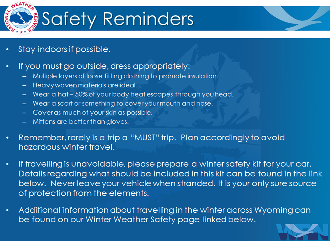
Winter Safety Kit | Winter Weather Safety
 |
Learn more about the National Weather Service's efforts to build a Weather-Ready Nation! |