
Scattered strong to severe thunderstorms will persist over the central to southern High Plains this weekend with a severe weather and flash flooding threat. A late season storm will bring low elevation rain and high elevation snow to portions of California, Nevada and Oregon through the weekend. Winter Weather Advisories are in place for the Sierra for snow totals of 3-6", locally higher. Read More >
Links | Map | Warnings, Radar, & Satellite | Fire & Thunder Forecasts
Outlooks and Climate| Fuels and Fire Danger Maps
Current Warnings, Radar, and Satellite
(Click thumbnails to expand Images)
 |
 |
|
|
Click Image to Enlarge Dubois Webcam - WYDOT |
|
|
|
|
|
 |
 |
 |
|
|
|
|
|
|
Storm Prediction Center Critical Fire Areas and Thunderstorm Forecasts
(Click thumbnails to expand Images)
|
|
|
|
 |
 |
 |
|
|
|
|
 |
 |
 |
|
|
|
|
 |
 |
 |
|
|
|
|
|
|
 |
 |
 |
 |
 |
|
|
|
|
|
|
 |

|
 |
 |
 |
|
|
|
|
|
|
 |

|
 |
 |
 |
Weather Outlook and Climate Information
(Click thumbnails to expand Images)
| Local Precipitation, Wind, and Humidity Information (NWS) |
|
|
|
|
|
 |
 |
 |
 |
|
|
|
|
|
 |
 |
 |
 |
|
|
|
|
|
|
|
 |
 |
 |
 |
|
|
|
|
|
 |
 |
 |
 |
USFS Fire Danger Graphics and Fuels
(Click thumbnails to expand Images)
|
|
|
|
 |
 |
 |
|
|
|
|
|
 |
 |
 |
 |
|
|
|
|
|
 |
 |
 |
 |
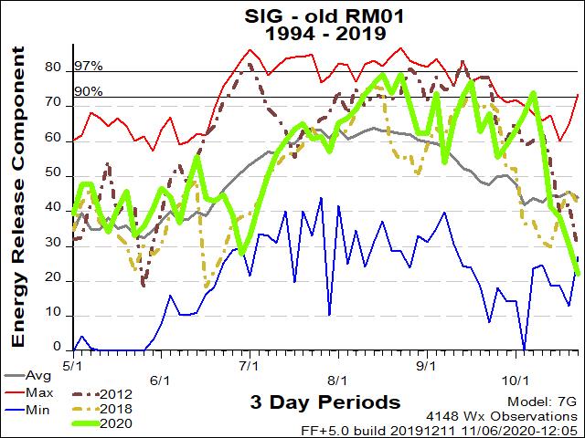
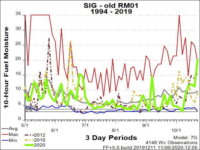
| RM01 ERC Fuels Graph |
|
|
 |
 |
 |
Return to NWS Riverton Homepage
 |
Building a Weather-Ready Nation |


